

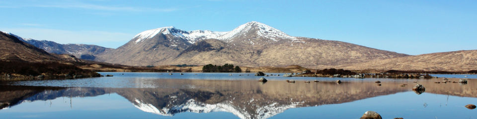
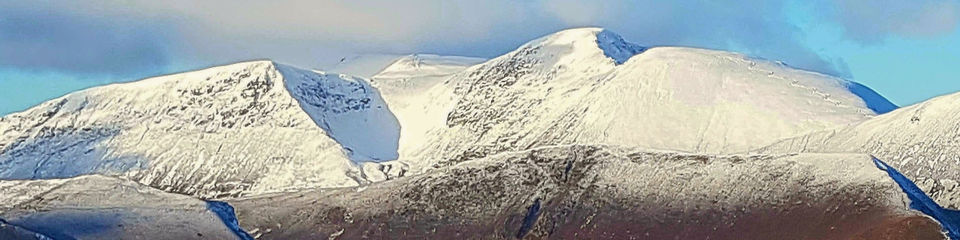
The Scottish winter season typically lasts from January to March but this varies from year to year, that said there are reasonable conditions in December and the highest areas, particularly Ben Nevis.
Hiking in the winter in particularly dangerous and you will need some additional gear that the we feel is necessary. Above all, you must make sure you carry and use a helmet all times while hiking in the winter, particularly the gully climbs on account of the potential for rock or ice fall. I would also take a single axe, a second axe may be appreciated on some of the longer gully lines.
Lean Conditions
Gullies can be several grades harder in lean conditions and are best left alone if they appear incomplete. Ridges will be normally be easier, more akin to their summer grading although icy conditions, particularly where running water has frozen can be very exacting.
Full-on Conditions
In deep fresh snow, ridge routes are safer than gullies from an avalanche hazard perspective. However, approaches must still be evaluated for avalanche danger and ploughing through deep snow is extremely hard work and could easily double your timings.
Cornices
Large cornices are often present at the top of large gullies which can make exiting gully routes very difficult - this can be a real sting-in-the-tail of an otherwise straightforward route. Large cornices are most likely to be found following a period of strong winds coming from the opposite aspect. For example, a NE facing gully could be expected to be heavily corniced after a period of strong south-westerly winds, particularly if accompanied by snow.
If you do, encounter a large cornice, it may be possible to outflank it. If you need to climb a suspect cornice, belay beneath it, preferably with the belayer out of the line of fire! If you are lucky, someone will have already cut a slot to clamber through but, if not, you may need to do this.
And don't rule out the possibility of backing-off. All the gullies on this site can be safely down-climbed with care, belaying and facing-in if necessary.
Avalanche Hazard
The general rules of avalanche avoidance are to be wary after heavy snow or during a rapid thaw; however, the subtle variations caused by earlier events and weather conditions are myriad. The Sports Scotland Avalanche Information Service (SAIS) provides daily avalanche forecasts for 5 key winter climbing areas in Scotland. The forecast can be obtained from www.sais.gov.uk and contains details of hazards, including the category (scale of 1 to 5, in increasing severity) and effect of terrain, particularly the slope aspect on the avalanche risk.
The route information indicates which forecast is most applicable to each route and you should try to tally up the forecast with the terrain (e.g. aspect of slope) encountered on the intended route. If the route seems threatened, consider changing plans before you start. If the category is 3, one of the ridge routes is likely to be a better bet.
Definitely avoid gullies or steep exposed slopes if a category 4 is forecast. However, even the ridge routes may have dangerous approaches and I have highlighted any specific risks that I am aware of. Be prepared to change your plans en route if you see evidence of recent activity or notice ‘slabs’ sliding as you cross steep ground. A winter skills course should help you identify some of the threats. Below are ten routes that you must walk this winter.
Castlegates Gully
This route takes you way from the crowds in the Northern Corries, 'over the back' to Loch A'an and the impressive cliffs of Shelter Stone Crag and Carn Etchachan.
Area: Northern Cairngorms
Grade: Winter grade I what does that mean?
Total Distance: 13 km
Total Ascent: 1050 m
Time: 7 hours
Maps: Ordnance Survey Landranger 1:50,000 Sheet 36
Avalanche Hazard: Both the approach to and return from Loch A'an cross a good deal of avalanche-prone terrain. It is best to avoid this route altogether after heavy snow or during thaw conditions. In such circumstances, consider other options such as the Fiacaill Ridge (of Coire an t-Sneachda), possibly continuing to Ben MacDui.
Avalanche Forecast Area: Northern Cairngorms more
Gear: A 50-metre rope, a small set of nuts and a couple of slings. Wear a helmet in the gully. Eminently solo-able.
Tips: Best left to later in the season when there is more daylight.
Alternatives: There are numerous other excellent climbs in the area. Refer to the SMC or Cicerone guidebooks for route decriptions.
Start - Park as for the Fiacaill ridges route.
Approach - Walk up the ski road alongside the funicular railway, passing under the railway and continuing up into Coire Cas. Break off the trail about 600 m beyond the railway and head for the ridge on your right, the Fiacaill a' Choire Cas. Climb the ridge to reach a large cairn at its top (point 1141).
From the cairn, descend SSE into Coire Rairbert towards the Loch A'an basin. The descent is gentle at first but soon steepens and care must be taken both to avoid a slip and to assess any avalanche risk. As the ground opens up above Loch A'an, start bearing right towards the western end of the loch. There is a small path alongside the loch but this may well be obliterated by snow.
At the end of the loch, you need to cross the Feidh Buidhe. If this is in spate, it may help to head upstream a little. Once across the Feidh Buidhe, walk across the boulder field beyond Shelter Stone crag to the far side of the cliffs. Start heading up the slopes towards the large cleft of Castlegates Gully.
Castlegates Gully - Although the surroundings are impressive, the gully is not steep, although it can be corniced, and you soon reach the plateau.
Carn Etchachan - You may as well take in the summit of Carn Etchachan, which is just 300 m (SSE) beyond the exit of Castlegates gully.
Descent - The descent requires careful navigation. First head east into the bowl of Garbh Uisge Beag. Traverse the bowl and make towards the head of Coire Domhain (NH992028). This is the start of the Goat Track, a steep descent from the plateau to Coire an t-Sneachda.
Escape Route - In avalanche prone conditions, it may be better to avoid the Goat Track. Head over to point 1178 then to point 1141 and descend via the Fiacaill a' Choire Cas as per the approach.
Return - From the floor of Coire an t-Sneachda, make your way through the boulder field (lochans!) and pick up tracks heading back to the ski centre.
The Couloir Map
A nice, reliable gully route with quick access from the Cairngorn ski centre, the Couloir is often one of the first routes to come into condition. Although the gully is not steep, the approach involves an airy traverse above the 'Great Slab'.
Area: Northern Cairngorms
Grade: Winter grade I what does that mean?
Total Distance: 9 km
Total Ascent: 630 m
Time: 5 hours
Maps: Ordnance Survey Landranger 1:50,000 Sheet 36
Avalanche hazard: Avalanches may occur on the approach slopes or in the Couloir itself so avoid in new snow or thaw conditions. In avalanche prone conditions, an excellent traverse of Carn Lochan can be made by ascending the Fiacaill Ridge (grade II) and descending by the descent route described here.
Avalanche Forecast area: Northern Cairngorms more
Gear: A 50-metre rope, a small set of nuts and a couple of slings. Put your helmet on when you arrive in the corrie as this is a popular venue and there are likely to be other climbers in the Couloir or on other climbs overlooking it!
Alternatives: There are numerous other excellent climbs in Coire an Lochain. Refer to the SMC or Cicerone guidebooks for route decriptions.
Start - Park as for the Fiacaill ridges route.
Approach - Walk in a westerly direction below the ski lifts along a well used path. When the path forks after about 500 m, take the lower path heading towards Coire an Lochain.
Follow this lower path for a further 500 m until it forks again, shortly after a stream crossing (allt Coire an t-Sneachda). Take the left branch towards Coire an Lochain. After a further 1¾ km, you will reach a large boulder field. Weave your way through the boulder field to arrive at the lochan at the foot of the corrie.
The Couloir - Bear left (E) of the lochan and head up steep slopes on the right hand edge of the 'Great Slab'. The Great Slab is a large area of smooth glaciated slabs at the centre of Coire an Lochain. It is renown for large full-depth avalanches!
Traverse beneath the crags above, passing under one large bay (the entrance to Y-Gully) before reaching the entrance to the Couloir. This can be awkward, especially under icy conditions. The exposure is considerable and some people may want a rope here. If so, you may be pleased to know that this section is arguably harder than the Couloir itself.
Climb the Couloir (2 or 3 pitches, about 100 m ascent), which slants right and brings you out on a small ridge, abutting the corrie rim. Thanks to this feature, cornices are rarely a problem. Follow the ridge over a short step to the plateau.
Cairn Lochan - Head left (E) for about 100 m to reach the summit of Cairn Lochan (only a small cairn). Reverse this last leg and then continue along the rim, watching out for in-cut gullies, until it is safe to head towards the north ridge of Cairn Lochan . In poor visibility, it may be better to make a 'dog-leg' to avoid the rim altogether.
Return - Follow the north ridge until the drops on the right (E) peter out and you can head back in a NE direction to pick up the path you followed on the approach
Ben Lui - Central Gully Map
The classic winter climb of the Southern Highlands, Central Gully is an absolute must for winter mountaineers. It was one of the earliest scottish winter routes climbed, conquered in 1892 by members of the embryonic Scottish Mountaineering Club.
Area: Southern Highlands, near Tyndrum
Grade: Winter grade I what does that mean? but more difficult in lean conditions
Total Distance: 17 km
Total Ascent: 1080 m
Time: 7½ hours
Maps: Ordnance Survey Landranger 1:50,000 Sheet 50
Avalanche hazard: Avoid Central Gully in new snow or thaw conditions as the steep approach slopes can slide. Avalanches have also occured in the gully itself. In avalanche prone conditions, the two ridges bounding Coire Gaothaich (ENE and NNE ridges) can be combined to make a nice circuit. The ENE ridge is an good route in its own right, probably Winter grade I.
Avalanche Forecast area: SAIS do not currently issue a forecast covering this area. Glencoe is the nearest but that's 30 km North of Ben Lui more
Gear: Take a 50-metre rope, some slings and a few nuts. Wear a helmet in Central Gully.
Tips: The approach involves a pleasant but long walk due west from Dalrigh on a good dirt road. If the road's not snowed up (and it's rare for it to be snowed up these days), a bike can be used and is recommended. It is possible to cycle some distance beyond Cononish and this will save around 1½ hours.
Start - Park in the car park at Dalrigh, about 3 miles north of Crianlarich on the A82. (Grid Reference NN344292)
Approach - From the car park, walk towards a small cluster of buildings. Follow the dirt road to the right of the buildings and take the right fork just beyond. Cross the river via a footbridge and ignore signs for the West Highland Way. Take the right fork just after the railway line and walk along the riverbank to the farm at Cononish (about 4 km from Dalrigh). Walk through the farm and continue along the track which heads WSW above the glen and eventually drops down to a river. As you approach, the sweeping arc of Ben Lui towers in front of you.
Ben Lui (1130 m) - Cross the river and ascend on the right (N) bank of the tributary stream descending from Coire Gaothaich. There is a reasonable path here. Stick to the bank of the stream until the gradient starts to ease as you enter Coire Gaothaich. Make for the centre of the corrie and the steep approach slopes leading to Central Gully.
The entrance to Central Gully can be identified by a triangular rock outcrop on its right hand side (ignore another feasible gully further left). Climb into the gully which narrows and trends left before opening up just below the summit ridge. Trend slightly right, where the cornice is usually not too large, and exit onto the ridge. Turn left (SSE) and walk to the summit, which is reached after only 75 m (distance). The gully involves about 150m of ascent.
Escape Route - From the summit, retrace your steps to where you exited Central Gully and continue to the subsidiary summit a short distance beyond. From here, follow the NNE ridge and descend right (E) into Coire Gaothaich from an obvious col (NN266267).
Descent - Warning The most interesting descent is made via the ENE ridge. However, this is grade I terrain and route-finding is difficult. If in doubt, it is probably best to descend the NNE ridge (see Escape Route).
If you decide to descend the ENE ridge, take care to locate it correctly - it starts just below the summit and can be easily overshot. Descend a narrow section, then stay right (S) of some large gullies that block the way. When the ridge levels off (NN270264), turn sharply left (NE) into Coire Gaothaich and rejoin the path you climbed on the ascent.
Return - Follow the track via Cononish to Dalrigh.
North ridge of Ben Cruachan
Although Ben Cruachan is normally climbed from the south, the remote north side is a much more impressive winter venue consisting of snowy corries and narrow ridges. This route takes you over one of those ridges - the north ridge of Ben Cruachan - and completes the day with a traverse of the the main Cruachan ridge.
Area: Southern Highlands
Grade: Winter I what does that mean?
Total Distance: 18 km
Total Ascent: 1650 m
Time: 10 hours
Maps: Ordnance Survey Landranger 1:50,000 Sheet 50
Avalanche hazard: Relatively safe.
Avalanche Forecast area: SAIS do not currently issue a forecast covering this area. The nearest forecast area is Glencoe. more
Tips: If there is a lot of snow low-down, it may be more realistic to tackle Ben Cruachan from the south on account of the length of the approach from the north. This variant is a good option if the A82 is closed at Tyndrum for snow.
Alternatives - The day could be extended by taking in Stob Dearg. The ridge known as the Drochaid Ghlas goes at similar grade to the north ridge of Ben Cruachan.
Start - Follow the A85 from Tyndrum towards Oban. About 2 miles west of Dalmally, take a minor road on your right signposted for Stronmilchan (ignore the first signpost to Stronmilchan). Park in a layby about 1/3 mile further on, just before a bridge. Grid Reference NN135287.
Lairg Noe - On the other side of the bridge, walk through a gate and follow an estate track north towards the obvious road cut into the hillside beneath Beinn Eunaich. Follow this road until you get to the tunnel workings close to the Lairg Noe. Follow the posts to the high point of the pass.
North ridge of Ben Cruachan - From the Lairg Noe, you can just make out the start of the north ridge, sandwiched between the mighty Drochaid Glas and Stob Dearg beyond. Descend WSW towards the very foot of the ridge (around NN083320).
After about 150 m ascent, the ridge becomes more clearly defined and climbs steeply to a point where it meets a subsidiary ridge joining from the left (E). From here, continue over narrow but flatter ground before the final pull up to the main Cruachan ridge. Turn right (W) and reach the summit of Ben Cruachan after a few minutes of scrambling.
Drochaid Ghlas - Turn round and head back along the ridge towards Drochaid Ghlas. Slightly beyound the point where you meet your ascent route, there is a tricky slab which is most easily overcome on the south (right hand) side. Continue on to Drochaid Ghlas.
Stob Diamh - From the summit of Drochaid Ghlas, double-back about 100 m (distance) until you can safely continue east along the ridge to Stob Diamh.
Stob Garbh - Follow the ridge south. A short descent and re-ascent takes you to the summit of Stob Garbh.
Descent - Walk SSE over the broad summit ridge of Stob Garbh for about 300 m (distance) and then bear left to pick up the ridge descending ESE
Return - The ridge brings you out at another large estate track which takes back to the road. Turn left and walk about 500m back to the car.
Armachan Ridge
The traverse of the knobbly Tarmachan ridge is a classic introductory route in the Southern Highlands but it is not without a few 'problems' of its own.
Area: Southern Highlands
Grade: Ungraded (hard) what does that mean?
Total Distance: 11 km
Total Ascent: 800 m
Time: 5 hours
Maps: - Ordnance Survey Landranger 1:50,000 Sheet 51
Avalanche hazard: Relatively safe.
Avalanche Forecast area: SAIS do not currently issue a forecast covering this area. Distant Glencoe is the nearest. more
Gear: It might be worth taking a short rope (25 m) and a crab/sling in case the 'bad step' is icy.
Tips: The minor road to the visitor centre and beyond is not kept open in winter and is best avoided if there is fresh snow about. If the road is impassable, park at the bottom and walk up. In this event, your best bet is probably the alternative route described.
The Tarmachan ridge, though narrow in places, is broad and meandering elsewhere. If the path is obilterated by snow and visibility is poor, navigation will be difficult.
Alternatives: The more usual approach is to park close to the Ben Lawers visitor centre, ascend the south ridge of Meall nan Tarmachan and descend via Creag na Caillich. However, this does not give as good a circular route as the route described here.
Start - From the A86 along Loch Tay, take the small road to the Ben Lawers Visitor Centre. Continue past the visitor centre, beyond the dam and past the north end of the reservoir (Lochan na Lairige). Park in a small lay-by marked by a cairn, about 500 m beyond the end of the reservoir.
Meall nan Tarmachan - Cross the road and head up the long, undulating north ridge of Creag an Lochain. It is probably best to cross the electric fence using the first stile and stay on its left until just beyond the summit of Creag an Lochain. Then cross the fence via another stile and proceed across an area of flat ground to a lochan (Lochan an Tairbh Uisge).
Head up broken ground at the southwest end of the lochan in the direction of the northeast ridge of Meall nan Tarmachan. Avoid a rock band by climbing an obvious gully on its right hand side; this gully normally holds a good amount of snow. Traverse right under crags for a short distance and then climb steepish slopes to gain the ridge. The ridge becomes more defined after this point and, after a series of bumps, levels off to bring you out on the summit of Meall nan Tarmachan (1044 m, cairn).
Escape Route - If you wish to descend at this point, you can obviously go back the way you came. Alternatively, you can descend the SE ridge of Meall nan Tarmachan, via point 923. This is the normal route and leads quickly back to the road just north of the visitor centre. However, this variation does entail about an hour's walk along the road to get back to the car.
Meall Garbh - From Meall nan Tarmachan, follow the broad ridge southwest, past a lochan, before a gradual ascent leads to the fine rocky peak of Meall Garbh. The ridge narrows considerably for a short distance here – this is the highlight of the day. After a short descent you reach the 'bad step' which is a tricky down-climb over an eroded rock band. It may be necessary to set up a belay or alternatively it is possible to bypass the step by descending steep slopes on the north side.
Beinn nan Eachan - Continue over a series of dips and rises to the summit of Beinn nan Eachan (1000 m).
Descent - Retrace your steps for about 300 m (distance) and start descending the north ridge of Beinn nan Eachan. The ridge is confusing at first but soon becomes better becomes defined. Follow the ridge over a series of humps until, about 1.5 km beyond the point at which you left the main ridge, the slopes on your right (E) become gentle enough to descend into Coire Riadhailt.
Return - Head ENE towards the other side of Coire Riadhailt, crossing a couple of burns, and pick up a vehicle track which heads back to the road. Turn right (E) and walk along the road for about 1 km to reach the car.
Stob Ghabhar
The ascent of Stob Ghabhar gives a nice circuit above a surprisingly spectacular corrie. Extra interest is provided by the ascent of the narrow Aonach Eagach ridge. This is not to be confused with the classic ridge in Glencoe but provides a short and interesting scramble nonetheless.
Area: Central Highlands
Grade: Ungraded what does that mean?
Total Distance: 16 km
Total Ascent: 1100 m
Time: 7 hours
Maps: - Ordnance Survey Landranger 1:50,000 Sheet 50
Avalanche hazard: Relatively safe.
Avalanche Forecast area: Glencoe is the nearest more
Alternatives: If you have two cars, you can leave one at the White Corries ski centre before setting out from Victoria Bridge. This would enable you to make a superb (and long) traverse from Stob Ghabar, over Clach Leathad and on to Meall a Bhuiridh.
Start - Leave the A82 at Bridge of Orchy and take the single lane road that heads west out of the village across the River Orchy. Follow the road for about 3 miles and park just before the road crosses river (Abhainn Shira) at Victoria Bridge. The road ends at the bridge. Grid Reference NN270418.
Approach - Cross Victoria Bridge to reach some buildings, turn left and walk along a wide track, signposted for Glen Etive, on the north bank of the Abhainn Shira. When you reach a green hut (about 1.5 km), turn right and follow the path on the left (E) bank of the Allt Toaig up the glen until you reach the lowest point of the ridge running between Stob Ghabhar and Stob a Choire Odhair.
Stob Ghabhar (1090 m) - Turn left and follow the ridge first west, then southwest to reach steeper slopes. Climb the steep ground, heading up the fall line (SSW), avoiding small rockbands as necessary to reach the the Aonach Eagach ridge. Follow the ridge right (W), negotiating a narrow section and climb the final steep slope to the summit of Stob Ghabhar.
Escape Route - From the summit, retrace the ascent route for around 500m (distance) and locate the ridge heading south over Stob Maol. If you get back to the narrow section, you've gone too far!
Descent - Follow the corrie rim as it arcs northwest, then north then eastwards. Navigation round the rim can be difficult in bad conditions and you should NOT follow the fence posts which continue to the north. All being well, you will reach the well defined ridge of Sron nan Giubhas after about 2 km.
Descend Sron nan Giubhas until you reach a small break in the crags on your right (S) at around 650 m altitude, which enables you to make a slanting descent rightwards down to the stream - Allt Coirein Dhearbhadh
Return - After crossing the stream, a little reascent brings you to back the col at the head of Coire Toaig. Head southeast and pick up the path back to Victoria Bridge.
Ballachulish Horseshoe
Beinn A Bheithir stands impressively above Ballachulish on Loch Leven and its sharp ridges hang down with alpine menace. The highlight of this route is the NE Ridge of Sgorr Bhan which turns out to be eminently 'do-able' and, when combined with the 3 summits of Beinn A Bheithir, makes for a terrific outing.
Area: Central Highlands, Glencoe
Grade: Winter I what does that mean?
Total Distance: 17 km
Total Ascent: 1300 m
Time: 7½ hours
Maps: Ordnance Survey Landranger 1:50,000 Sheet 41
Avalanche hazard: Relatively safe.
Avalanche Forecast area: Glencoe more
Gear: 25-metre rope.
Tips: 2 cars, if available, would save a walk along the road at the end of the day. Alternatively, there is a taxi driver in Glencoe!
Alternatives: If the rock is icy or there is a lot of new snow, the NE ridge of Sgorr Bhan can be trying. The easier alternative is to ascend the NNE ridge.
Start - Take the first signpost for Ballachulish shortly after you pass Glencoe, traveling West on the A82. Turn left before the pub (Laroch Arms) and continue, crossing over a bridge after about 200 m. Park in a small car park on the left a little beyond the bridge. Grid Reference NN104589.
Approach - Walk back to the bridge and follow signs to Glen Creran. Walk through gates at the side of a farmhouse to reach a good path which heads in a southerly direction towards Glen Creran. Follow the track through a gate and around the foot of the NE Ridge of Sgorr Bhan until you reach the far (Eastern) side of the ridge - about 600 m in distance
Sgorr Bhan - Break off the path and head right (W) across bracken and heather, ascending the moderately angled slope to gain the crest of the ridge. Follow the ridge, which is straightforward to begin with but you soon come to a number of rock steps which can give problems if the rock is icy or plastered with soft snow - a rope may well be required here.
Above these steps, the ridge eases off and joins with the NNE ridge (from the right) shortly before the summit is reached.
Escape Route - If it's been enough already, retrace your steps to locate the NNE ridge which gives a straightforward descent
Sgorr Dhearg - Follow the 'banana-shaped' ridge towards Sgorr Dhearg, giving ample clearance to any cornice on your right (N) side. You are now 1/2 way
Sgorr Dhonuill - From the summit of Sgorr Dhearg, the ridge drops down significantly to a bealach at around 760 m. It then reascends, steeply at first, before narrowing as you approach the nice rocky summit of Sgorr Dhonuill
Descent - Continue along the ridge, WSW at first, gradually veering north. About 1.4 km beyond Sgorr Dhonuill you come to a broad, inviting gully. Descend the gully, which will probably be snow-filled, to reach the forested glen below. Make your way through the dense wood and pick up the forestry road that finally takes you back to South Ballachulish
Return - Walk back to Ballachulish along the A82 to collect your car. At least there is the Laroch Arms to look forward to
Climber's Col
Although there are more sought-after ridges in Glencoe and the Mamores, and rightly so, the back corries of Aonoch Mor provide some of the most reliable winter conditions on the west coast. This little ridge can provide a good winter outing even when the aforementioned mountains are bare.
Area: Central Highlands, just north of Fort William
Grade: Ungraded (hard) what does that mean? Mainly straightforward but there is a cornice to overcome.
Total Distance: 7.5 km
Total Ascent: 450 m
Time: 4 hours
Maps: Ordnance Survey Landranger 1:50,000 Sheet 41
Avalanche hazard: Serious avalanches have occurred on the approach slopes despite the seemingly benign nature of the terrain. The ridge itself is safe apart from the cornice. In avalanche-prone conditions, it is safer to ascend the Nid ridge, sticking close to the rock where possible.
Avalanche Forecast area: Lochaber. more
Gear: Take a 50-metre rope and some slings in case you need to belay below the cornice. Wear a helmet on the approach as there are often training parties on the slopes above, practicing belays etc.
Tips: In winter there is a walker/climber's gondola at 8:00 am, whereas the main service commences at 9:30 am. The last gondola down is usually around 4 pm but check opening/closing times with the resort to ensure normal operation. Currently, the gondola costs £8.50 for walkers/climbers. www.nevisrange.co.uk. Bear in mind you are entering a ski area and the approach is actually a patrolled run.
Alternatives: Easy gully is a large grade I gully further round on the east face of Aonach Mor. It is often used in descent for access to the climbing areas.
Other routes in the area: There are many good winter climbs on the east face of Aonach Mor. Refer to the SMC or Cicerone guidebooks for route descriptions.
Start
Park at the Nevis Range Ski Resort. This is located on the A82, about 7 km north of Fort William, and the turn-off is clearly sign-posted.
Buy a walker/climber's ticket which enables you to take the gondola to the top station at 650 m on Aonach Mor. Grid Reference NN171773.
Approach - When you alight from the gondola, follow ski fences ESE towards the foot of the Nid ridge. Traverse below the foot of the Nid ridge and keep going until you reach the Braveheart chairlift. The route follows the ridge just beyond.
Climbers Col - The best place to gain the crest is probably 2 pylons down from the top of the lift. Climb the steep slopes to the crest, which is pleasantly narrow in places, without being too vertiginous. High up on the ridge, there is a slight flattening. This is the Climber's Col and is used for access to the main climbing area.
This route continues up to join the main Nid ridge but the way is often blocked by a large cornice. At least you get a good opportunity to stop and assess it! It can either be climbed direct or bypassed by traversing right to gain the Nid ridge further along.
Aonach Mor (1221m) - Follow the Nid ridge left (S), watching out for crags on your left (E), until you reach the hut at the top of 'Summit run'.
Escape Route -You can descend via Summit run but stay off the pistes. From the bottom of Summit run, descend into the Snow goose area and back to the gondola top station.
To continue to the summit of Aonach Mor, continue in a generally southerly direction, taking care not to walk onto a cornice. In poor visibility, very precise navigation is required.
Descent - From the summit cairn, reverse your tracks to the top of the ridge above the Climber's col. Continue to descend the Nid ridge which is easily followed until its end, where the ground is steeper and you need to pick your way around rock outcrops.
Return - Follow the fence back to the gondola top station.
CMD Arete Map Photos
The traverse of the CMD (Carn Mor Dearg) Arete, combined with an ascent of Ben Nevis, makes for a classic mountaineering day. Once established on the ridge, there are no good escape routes. The views of the north face of the Ben are breath-taking.
Area: Central Highlands
Grade: Winter I what does that mean?
Total Distance: 15 km
Total Ascent: 1650 m
Time: 8 hours
Maps: Ordnance Survey Landranger 1:50,000 Sheet 41
Avalanche hazard: Relatively safe.
Avalanche Forecast area: Lochaber more
Tips: Over recent years, the Ben has been the place to be later in the season when the extra altitude results in good snow cover. The longer days don't hurt either, given the length of the route.
Alternatives: The CMD arete can be reached from the Aonach Mor gondola via the Carn Dearg Meadhonach route.
Start - Park at the North Face car park, which is inconspicuously signposted from the A82 at Torlundy. Grid Reference NN144764.
Approach - Follow the continuation of the road for about 100 m until you reach a path on your right, signposted 'Allt A Mhuilinn path'. Follow this path for another 100 m at which point a cross-roads is reached. Take the path on the left, which climbs uphill through the trees. A fork is reached after about twenty minutes; follow the left branch until another fork is reached soon afterwards. This time take the right branch and follow it to a forest road. Walk up the road to a higher car park where a stile leads to the Allt A Mhuilinn path.
Carn Dearg Meadhonach - About 750 m (distance) beyond the higher car park, leave the Allt A Mhuilinn path and pick up an indistinct path on your left, which slants southtwest up the mountainside and skirts the minor top of Carn Beag Dearg to gain the ridge below the summit of Carn Dearg Meadhonach. Watch out for large cornices that form on the left (north) side of the ridge. Continue up to reach the large summit cairn.
CMD Arête - Press on to the the next summit - Carn Mor Mor Dearg. Beyond is the start of the CMD (Carn Mor Dearg) Arête. The ridge is normally wide enough to walk comfortably, although there are a few steps where hands may be required. The ridge sweeps round, flattening briefly at the col at the head of Coire Leis (there is a metal abseil marker here) before starting its relentless rise to the Ben.
Ben Nevis - From the col, follow the ridge upwards towards the summit of the Ben, giving wide berth to the edge on your right. When the ridge widens, head NW towards the summit. The summit is unmistakable because it is topped by a large shelter.
Descent - Warning Navigation on Ben Nevis is notoriously difficult. In bad visibility, it is vital that you follow the detailed directions given below. A detailed summit map can be found here.
Summit Map - Follow the standard descent procedure, Follow a bearing of 231° for 140 m (distance) from the summit shelter. Then follow a bearing of 282° for 2 km to clear all difficulties.Head north towards the 'half-way lochan' (Lochan Meall an t-Suidhe).
Return - Shortly before you reach the half-way lochan, pick up the path which heads north initially and then traverses the foot of Carn Dearg. Leave this path when it starts to turn northeast and continue in a northerly direction to meet the Allt a Mhuilinn.
Follow the bank of the Allt a Mhuilinn to a bridge a couple of hundred metres beyond the higher car park (i.e. downstream of it). Cross the bridge and pick follow the route you took on the ascent back to the North Face car park.
Alternative Descent - In good visibility and snow conditions, it is possible to descend from the summit of Ben Nevis via No. 4 Gully. To do this, follow a grid bearing of 231° for 140 m (distance) from the summit shelter, as per the normal descent descibed above. Continue along the rim, giving extra-wide berth to the incut gullies until you reach the top of No.4 gully, which is marked by a metal post with the number 4 in it. If the cornice is impassable or the snow conditions are not as good as you thought, head back along the rim and follow the the normal descent route via the half-way lochan.
The descent of No. 4 is steep at first and it's best to face in to down-climb. However, it soon eases off and leads to a wide bay. Descend to the CIC hut and walk back along the Allt A Mhuilinn.
Dorsal arete & Bidean Nan Bian
A neat little route taking you to the summit of one of the most beautiful Scottish mountains in the heart of the Bidean Nan Bian massif in Glencoe.
Area: Central Highlands, Glencoe
Grade: Winter II what does that mean?
Total Distance: 9 km
Total Ascent: 1290 m
Time: 7 hours
Maps: Ordnance Survey Landranger 1:50,000 Sheet 41
Avalanche hazard: Once established on Dorsal Arête, the route is relatively safe. However, be wary on the steep approach slopes leading from the corrie floor to the start of the arête, as these are set at a good angle to avalanche!
Avalanche Forecast area: Glencoe more
Gear: A 50-metre rope, a small set of nuts and a couple of slings. Helmets should be worn.
Alternatives: You can ascend Stob Coire nan Lochan via the 'Zig-Zags' route of Gearr Aonach (winter grade I, althrough rarely in condition nowadays) and continuing up the west ridge of Stob Coire nan Lochan. There are numerous other climbing routes in Coire nan Lochan. Broad Gully, immediatley left (SE) of Dorsal Arête, is a straightforward route at winter grade I. Another popular route climbs the broken ground left (E) of the main summit buttress.
Start
Park at one of the large car parks on the South side of the A82, 6-7 km South of Glencoe village.
Grid Reference NN171569.
Approach
Make a short descent from the car park to pick up the 'old' road. Follow this west for 350 m and pick up a path heading south which crosses the River Coe via a footbridge at GR NN167556. Ascend the path which follows the left (E) bank of the stream running down from Coire nan Lochan. This path climbs relentlessly to a height of about 700m where steep crags appear to bar the way. The best way from here is normally to bypass the crags on their right (W) via a scree (or snow) filled gully. Climb the gully to reach Corrie nan Lochan above.
Dorsal Arête to Stob Coire nan Lochan
Dorsal Arête is the broad-ish ridge immediately right of a prominent gully called Broad Gully, which is located towards the left hand (E) side of the corrie, just right of the summit block. Reach the foot of the ridge by ascending steep snow slopes. Gain the ridge on relatively easy ground on its left hand side, about 20 m (height) above its lowest point. Climb through easy rock steps until a small pinnacle is reached as the ridge narrows to a knife-edge.
Make a short, exposed traverse above Broad Gully to avoid the knife-edge (there are usually good options for belays) and then regain the crest to reach a platform below a short, shallow chimney. There is a good block for the belay. Climb the chimney, above which the ground flattens out to reach the summit ridge. A short ascent will take you to the summit of Stob Coire nan Lochan.
Bidean Nan Bian
Descend the south ridge of Stob Coire nan Lochan until a col is reached and begin the steepish ascent to Bidean nan Bian. Retrace your steps to Stob Coire nan Lochan. The round-trip takes about an hour and can obvioulsy be ommitted in bad weather.
Descent
From the summit of Stob Coire nan Lochan, descend the north west ridge in the direction of Aonach Dubh, past Broad Gully and Dorsal Arete, taking care to avoid crags on the left (E). When the ground levels off (about 600m distance), drop back into Coire nan Lochan on your right (E). Return by your ascent path to the car.
East Ridge of Beinn a Chaorainn
This is a pleasingly long and enjoyable ridge and is less well travelled than the nearby crags of Creag Meagaidh.
Area: Central Highlands
Grade: Winter I what does that mean?
Total Distance: 13 km
Total Ascent: 835 m
Time: 5½ hours
Maps: Ordnance Survey Landranger 1:50,000 Sheet 34
Avalanche Forecast area: Creag Meagaidh more
Gear: Take a 25-metre rope, a selection of nuts and some slings.
Alternatives: You could combine this route with an ascent of Creag Meagaidh. Continue upwards from the Bealach a Bharnish to Creag Meagaidh and descend its south ridge (follow the stone wall).
Start - The route lies along the A86 between Spean Bridge and Laggan. Park in a small layby about 30 m east of where the A86 crossed the Allt na h-Uamha. There is a waterfall clearly visible by the roadside at this point. Grid Reference NN400818.
Approach - Follow a small path on the right (west) bank of the Allt na h-Uamha that takes you through a plantation. The path does its best to weave through the trees but the first few hundred metres (distance) are pretty desperate and you have to force your way through the trees. After this initial section, head back to the burn as the land alongside the bank is largely free of forestation.
Follow a the burn (small path) until you reach the end of the plantation (NN402828). Turn left and follow the plantation edge (fence) until you reach a forestry road after 200 m.
Follow the road through another plantation until you clear the trees (NN399850). Turn left and follow the plantation edge to the end and continue east across rising moorland to the foot of the East Ridge of Beinn a Chaorainn.
East Ridge of Beinn a Chaorainn - Ascend the foot of the ridge to reach a flatter section which then leads to a steep section. Work your way up the steep section via a series of small gullies finishing up with a short but delicate rock step (crux). Above this, stick as close to the crest of the ridge as you can, finally reaching the slopes directly below the summit of Beinn a Chaorainn.
Escape Route - Once on the ridge, there are no easy escape routes. A quick escape can be made from the summit by descending the northeast ridge, which descends from the south summit (Point 1049). However, caution is required on account of the incut gully south of the main summit which is not terribly obvious on the map and is a known accident blackspot.
Beinn a Chaorainn - From the summit, head right (north) to the subsidiary summit Point 1044, taking care to avoid the in-cut gully. From Point 1044, continue north and follow the ridge that descends to the Bealach a Bharnish. From here gentle slopes lead into Coire na h-Uamha.
Return - Stay on the right (west) bank of the burn and return to the point where you exited the second plantation. There are landrover tracks that will lead you pack to this point, if they are not covered by snow. Return via the approach route to the car.