
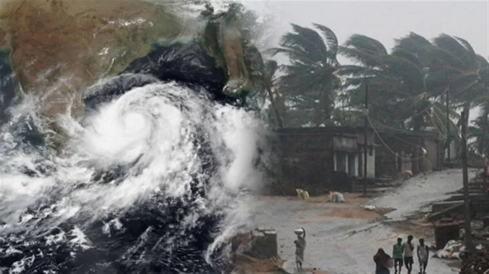
The western Indian states had barely started picking debris left behind by the cyclonic storm Tauk'tae when the grim news of another cyclone named 'Yaas' started brewing up. Infamously being touted as a close cousin to 'Amphan' (a cyclone which wrecked havoc in Odisha and West Bengal precisely a year back),
Yaas: What's in a name?
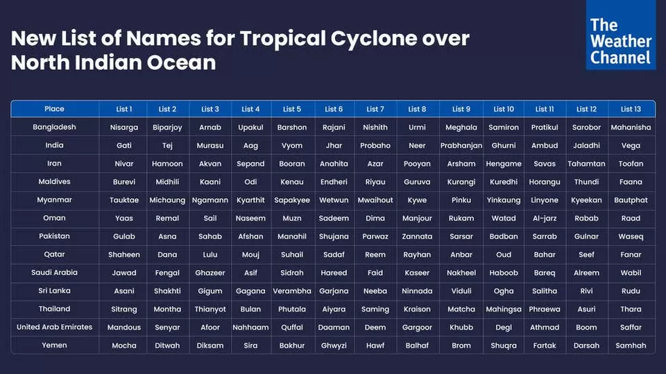
In the year 2000, a group of 13 nations known as WMO/ESCAP (World Meteorological Organisation/United Nations Economic and Social Commission for Asia and the Pacific) came up with a process of naming cyclones emerging from the north Indian Ocean, including the Bay of Bengal and Arabian Sea. These 13 nations, of which India is a part, suggested 13 names each - thus forming a list of 169 names which were to be given to upcoming cyclones in the region. As per the list, the cyclone coming up next to Tauk'tae is named as 'Yaas'. The name 'Yaas' was suggested by Oman.
Origin, movement and landfall of the Cyclone
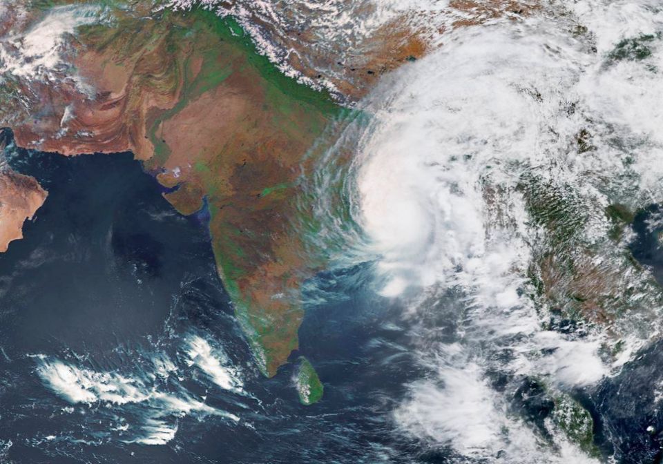
As is widely known, tropical cyclones occur over tropical oceans/seas because of warm and moist air that is trying to escape into the atmosphere. This creates a low pressure system, where the water and air meet. Cyclones then develop in these low air pressure areas. The greater the temperature difference, greater the low pressure and stronger the cyclone.
Yaas is expected to start forming in Bay of Bengal around May 22, 2021 from where it is expected to move northwestwards to reach Odisha. It is expected to make a landfall in Balasor (Odisha) on May 26, 2021. The most affected states, as predicted, will be coastal Odisha, West Bengal and Andhra Pradesh along with Union Territory of Andaman and Nicobar Islands. You can check the precisely expected movement of the cyclone is in the video below:
Category and intensity
The Indian Meteorological Department categories cyclonic storms into five categories, based on the sustained wind speed caused by the cyclone. A detailed description of these categories is imminent from the picture below:
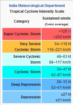
As per certain prediction models, the wind speeds caused by Yaas are expected to be in the range of 140 - 150 kmph, making it fall into the 'Very Severe Cyclonic Storm' category. To put things in perspective, the recent cyclone Tauk'tae was also in the same category of severity with sustained wind speeds in the range of 90 - 120 kmph at the time of landfall.
Evacuation and other measures by the state government
As per media reports, Odisha government has already issued guidelines to keep flood and cyclone shelters in readiness. Concerned departments have been asked to make preparations to ensure an unhindered drinking water supply as well as a detailed plan for clearing of roads, tree cutting and other anticipated restoration works. Animal and Fisheries department to create awareness in coastal belts to prevent entry of fishermen into the sea. Efforts will also be taken to ensure safe return of fishermen still in deep sea.
While the states of Odisha and West Bengal still shiver by the name of last year's cyclone Amphan, western coastal states of Kerala, Goa, Maharashtra and Gujarat are reeling by the wreck left behind by Tauk'tae. Amidst all this, may the entire community pray for well-being and protection against this brewing up giant.
Looking for latest in travel news and trends? Follow Tripoto on Facebook and Instagram for more!
You can also share your travel stories on Tripoto by creating a blog here.


' fill='%23359391'%3e %3cpath d='M46.1538462%2c43.5714286 L41.5%2c50 L36.8461538%2c43.5714286 L36.8670256%2c43.5714286 C36.3173077%2c42.7142857 36%2c41.6851429 36%2c40.5714286 C36%2c37.4854286 38.4535641%2c35 41.5%2c35 C44.5464359%2c35 47%2c37.4854286 47%2c40.5714286 C47%2c41.6851429 46.6826923%2c42.7142857 46.1329744%2c43.5714286 L46.1538462%2c43.5714286 Z M41.4294872%2c39 C40.6150641%2c39 39.9487179%2c39.675 39.9487179%2c40.5 C39.9487179%2c41.325 40.6150641%2c42 41.4294872%2c42 C42.2439103%2c42 42.9102564%2c41.325 42.9102564%2c40.5 C42.9102564%2c39.675 42.2439103%2c39 41.4294872%2c39 L41.4294872%2c39 Z' id='Location-white'%3e%3c/path%3e %3c/g%3e %3c/svg%3e)