Just a glimpse at the list of the valleys in India is like taking a quick and hard-hitting shot of wanderlust. Given the number of magical valleys in India, any attempt in trying to put down every single one of them would be over-ambitious. So, here are a few of the most beautiful, mysterious and overlooked valleys that are located in the northern and north-eastern parts of India.
Here's a list of the most beautiful valleys in India that you must visit
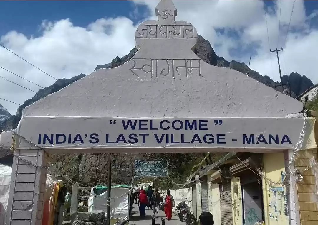
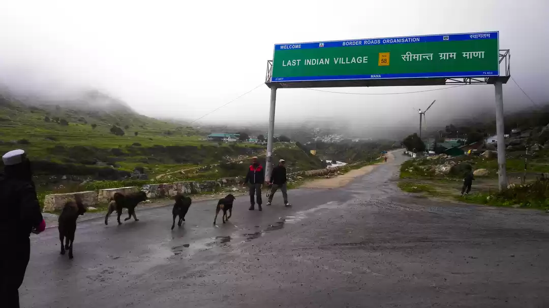
1. Mana Valley
Chamoli District, Uttarakhand
Mana Village, in the valley, holds great importance in Hindu mythology as being the place where Maharishi Vyas narrated the epic of Mahabharata to god Ganesha. The famous Badrinath Shrine is just 3km away from the Mana Village. The Mana Valley also holds the source to the longest tributary of Ganges, the Alaknanda River.

How to reach: The nearest airport is Jolly Grant in Dehradun and the nearest railhead is Rishikesh. After reaching these places, you will have to either take an early morning bus, shared taxi or drive down yourself till Badrinath via Joshimath.
While you are there: The Mana La on the border between India and Tibet is the highest accessible pass in the world at 18,192 ft. The Mana Village is famously called the last village of India. It is from Mana La that you start the ascent to Chaukhamba Peak. Also visit the two small caves in Mana – Vyas Gufa and Ganesha Gufa. Other natural attractions are the Vasundhara Falls, Satopanth Lake and Bhim Pul.
2. Pindar Valley
Bageshwar District, Uttarakhand
This is one of the lesser known valleys in India. Flourishing along the Pindari River, the Pindar Valley is situated in the Kumaon Region's picturesque district of Bageshwar. The river passes through a string of small hamlets such as Devaal, Tharali, Kulsari, Harmani, Meeng, Narain Bagar and Nalgaon. The Pindari River is a tributary of the Alaknanda, which it meets at Karanprayag.

How to reach: The nearest airport is in Pantnagar (136km from Bageshwar) and the nearest railhead is Kathgodam. After reaching these places, you will have to either take an early morning bus, shared taxi or drive down yourself till Bageshwar via Almora.
While you are there: The fascinating limestone cave temple of Patal Bhuvaneshwar falls on the way to Bageshwar. The Pindar Valley itself is famous for small isolated villages such as Dhurr and and you can spend time hiking to these places. To take it a step higher, trek to the Pindari Glacier, the source of the Pindari River.
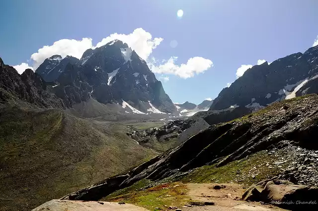
3. Darma Valley
Pithoragarh District, Uttarakhand
The valley by Darma Ganga is nestled between Kuth Yangti Valley in the east and Lassar Yangti Valley in the west. This high-altitude Himalayan Valley in Pithoragarh can only be accessed on foot and falls en route the famous trek to the Panchachulli Basecamp. Given the close proximity to the Indo-Tibetan border, you get a glimpse of the Kailash peak on way to the Sin La. Darma is one of the most beautiful valleys in India.

How to reach: The nearest airport is Naini Saini in Pithoragarh and the nearest railhead is in Tanakpur. After reaching these places, you will have to either take an early morning bus, shared taxi or drive down yourself till Dharchulla.
While you are there: Trekking in the Darma Valley is an enthralling experience that every mountain lover needs to experience once in a lifetime. The terrain to Panchachulli Basecamp changes from glaciers to coniferous forests. It is believed that the Pandavas cooked their last meal on the peaks of Panchachulli before ascending to heaven. You can take the route of Dhauliganga from Dugtu to Tidang and Bidang villages over Sin La into the Byans Valley.
4. Pin Valley
Lahaul and Spiti District, Himachal Pradesh
When you move towards the southeast of Kaza, you will find the meandering Spiti River joined by the Pin River. The Pin Valley is a fascinating landscape, which hosts some of the most unique flora and fauna in the world. Most of the valley falls within the Cold Desert Biosphere Reserve, and the Pin Valley National Park spreads from the south of Dhankar Monastery (near the Tibetan border) to the end of the Spiti Valley. Its highest point is at a Kinnaur Village, Ka Dogri, at 20,000 ft.

How to reach: The nearest airport is in Bhuntar (252km from Pin Valley) and the nearest railhead is in Jogindernagar. Local buses from both Manali and Shimla also operate till Kaza on a strict time schedule. After reaching these places, you will have to either take an early morning bus, shared taxi or drive down yourself till Pin Valley. The two available routes are from Manali via Rohtang Pass and Shimla via Reckong Peo.
While you are there: Do visit the 680-year-old Ugyen Sangnak Choling Gompa and its huge new monastery building. There are also three medieval shrines decorated with blackened murals, snow lions and festival masks. The trail from Sagnam Village to Mudh makes for a great one-day trek. From here you can take longer treks to Pin-Parvati Pass, Bhaba Pass and Kaphnu in Kinnaur.
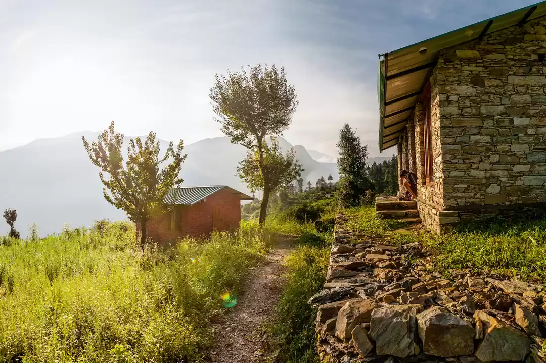
5. Tirthan Valley
Kullu District, Himachal Pradesh
Tirtan is one of the more frequented valleys in India. Located near the Tirthan River in the Himalayas, the Tirthan Valley is a cozy hidden hill-town situated on the periphery of the Great Himalayan National Park (GHNP). Only 3km from GHNP, the Tirthan Valley has an abundance of flora and fauna that are unique to the region. There are several quaint hamlets in the valley that are ideal for peaceful and exploratory hikes.

How to reach: The nearest airport is in Bhuntar (80km from Tirthan) and the nearest railhead is in Kiratpur. Every bus to Kullu or Manali passes through Aut, which is where you should get off. After reaching here, you will have to either take an early morning bus or shared taxi till Shojha or Jibhi.
While you are there: There are several camping sites in the two major towns of Tirthan, Shojha and Jibhi. These camps organise adventure sports, such as zip-lining and river crossing by rope. Do not miss out on a chance to trek inside The Great Himalayan National Park. Hikes to Jalori Pass, Serloskar Lake, Neuli, Gushaini and Bhagi Kashahri are some great trails within the national park.
6. Kangra Valley
Kangra District, Himachal Pradesh
The Kangra Valley has an abundance of Deodar forests that can refresh the spirit of a traveller. It is also home to a large community of Tibetan refugees who have found solace in the peaceful and benevolent mountains of Himachal. To explore the Kangra Valley, you will need a minimum of seven days (if you are starting from Delhi).

How to reach: The nearest airport is Gaggal Airport (14km from Dharamshala) and the nearest railhead is in Pathankot. You can get a direct bus from Delhi to either Dharamshala or Mandi. After reaching these places, you will have to either take an early morning bus or shared taxi to explore deeper into the valley.
While you are there: From Mandi you can take a bus or taxi to Baggi Village and trek to the beautiful Prashar Lake. You can even spend the night at a small guesthouse near the lake. In Bir, visit the iconic Choukling Monastery. It is situated in the Bir Tibetan Colony and is easily reached on foot. You can also take time to go paragliding in Billing, the paragliding capital of India. Don't miss out on the famous Kangra Fort, which was built by the Katoch Dynasty and is considered the largest fort in the Himalayas.
7. Warwan Valley
Kishtwar District, Kashmir
Warwan is north India's best kept secret. Bound by the lush green forests of Kashmir Valley on one side and cold desert of Ladakh on the other, Warwan is an isolated piece of heaven. The valley can only be accessed for a few summer months and remains closed for 7 months in a year.

How to reach: The nearest airport is in Srinagar and the nearest railhead is in Jammu. Warwan is three hours away from Kokernag in Anantag. After reaching these places, you will have to either take an early morning bus or shared taxi to explore deeper into the valley.
While you are there: The best and only way to explore the depths of Warwan Valley is to take an exploratory trek through the many terrains, ranging from massive Bracken glaciers and moraines to miles of undulating meadows. Check out this trek to know more.
8. Lidder Valley
Anantnag District, Kashmir
Originating from the Kolhoi Glacier, the Lidder River is a major tributary of Jhelum which feeds the entire Kashmir Valley. The entrance to Lidder Valley is just 7km from Anantnag town. Similar to Warwan, the Lidder Valley is surrounded by the green Pir Panjal Range in the South and by Sindh and Zanskar Range in the North. The Lidder River has been mentioned in Hindu Mythology for having religious significance, as the East Lidder originates from the holy Sheshnaag Lake. Some major towns in the valley are Mandlan, Laripora, Phraslun, Ashmuqam and Seer Hamdan.

How to reach: The nearest airport is in Srinagar and the nearest railhead is in Jammu. Lidder is just 7km away from Anantag. After reaching these places, you will have to either take an early morning bus or shared taxi to explore deeper into the valley.
While you are there: The moderately-challenging trek to Kolhoi Glacier is a must for those who want to experience the varied terrains of the valleys. If you don't wish to go as far as Kolhoi, then a hike to Aru Village is equally rewarding. On the way to Lidder, there are remains of an ancient Vishnu temple in Avantipora, which was built by the king Avantivarman who reigned from 855 – 883 CE. There is also a Guru Nanak Dev Gurudwara, which is believed to be the Sikh Guru's resting place on his tour of the Eastern Himalayas.
9. Nubra Valley
Leh District, Ladakh
The Nubra Valley of Ladakh was once called Ldumra, the valley of flowers. A name that seems highly unlikely for a cold desert, holds true for this valley by the Shyok River. The bright colours contrast with the dry brown and deep blue sky to create a surreal scenery. The Shyok River is a tributary of the mighty Indus River that flows through the Karakoram Ranges. Nubra Valley has an average altitude of 10,000ft and most villages are perched even higher than that, making it a difficult destination and place to live in. The famous Siachen Glacier also lies in the extreme north Nubra Valley.

How to reach: The nearest airport is in Leh (150km from Leh) and the nearest railhead is in Jammu. After reaching these places, you will have to either take an early morning bus or shared taxi to reach and explore the valley.
While you are there: The Nubra Valley is marked by the 32m high Maitreya Buddha statue in Diskit. The Diskit Monastery, built in 1420 BCE, is the largest monastery of Nubra Valley. Earlier, Nubra Kingdom spread to regions of Gilgit-Baltistan but despite the borders closing in, the Nubra Valley remains home to the Balti Tribe. The valley is most well-known for several kilometres of sand dunes, which are the natural habitat to bactrian camels who graze in the rare forests of seabuckthorn. Turtuk, a village deep in the Nubra Valley, was closed off for tourists until 2010, when the government started allowing Indian travellers to explore the place without a permit.
10. Dibang Valley
Upper and Lower Dibang Districts, Arunachal Pradesh
The remote Dibang Valley of Arunachal Pradesh is divided into two separate districts, Upper Dibang Valley and Lower Dibang Valley. Despite being the largest district in India with an area of 9,129 sq. km, Upper Dibang Valley is the least populated district in India. The history of Anini, the district headquarters of Upper Dibang is unknown. The place is inhabited by the native Idu Mishmis and few other tribes who migrated from ancient Tibet a thousand years ago. Anini is the only place in Upper Dibang which has proper access to the rest of India. The forest, which is now called the Dibang Wildlife Sanctuary is considered to be the richest biosphere in Eastern Himalayas. A never seen before flying squirrel spotted in the Mishmi jungles, is now named after the area, Mishmi Hills Giant Flying Squirrel (Petaurista mishmiensis).

How to reach: The nearest airport is Dibrugarh Airport and the nearest railhead is in Tinsukia. After reaching these places, you will have to take a taxi to reach and explore the valley. Note that roads for Upper Dibang Valley go only till Anini.
While you are there: If you are interested in exploring the Lower Dibang Valley, then several tour operators and local agencies offer exploratory treks. These treks begin at Roing, explore Mishmi Village and go till Nizam Ghat. As for Upper Dibang Valley, you can explore the dense Dibang Wildlife Sanctuary or hike around the remote town of Anini. Being a sensitive area, travel to certain areas in the Dibang Valley will require permits, so be prepared.
11. Dzukou Valley
Kohima District, Nagaland and Senapati District, Manipur
The beautiful valley of Dzukou is located right at the border of Nagaland and Manipur. Similar to the Valley of Flowers in Uttarakhand, the Dzukou Valley too can only be reached through trekking trails. The two known entries are from the foothills of Viswema Village and through Jakhama Village (also written as Zakhama). Both of these routes start in Nagaland and are easily accessible through Kohima. The Dzukou Valley is world renowned for a unique species of the lily flower, which is found nowhere else in the world, the Dzukou Lily. Other than the Dzukou Lily, the valley's undulating grasslands are decorated by several beautiful varieties of wildflowers every season.

How to reach: The nearest airport is Dimapur Airport and the nearest railhead is in Dimapur. After reaching these places, you will have to take a taxi to reach Jakhama or Viswkema and then trek from there.
While you are there: If you wish to enter Dzukou Valley through Manipur then take the five-hour long trail from Mount Isu in Senapati District. This route was recently opened by the Manipur Mountaineering and Trekking Association. The Pulie Badze Wildlife Sanctuary is a must visit for bird watchers, it situated right in between the crisscross of Japfy and Dzulekie mountain streams. The Dzukou Valley is situated at the foot of Japfu Peak. For trekkers who wish to challenge themselves, the second highest peak of Nagaland is the ideal challenge.
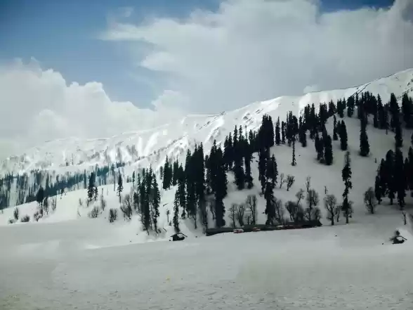
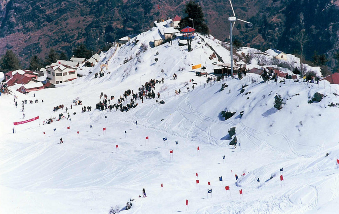
12. Yumthang Valley
North Sikkim District, Sikkim
Situated in the lap of Eastern Himalayas at an altitude of 11,693ft, the Yumthang Valley is the rhododendron heaven of India. Flourished by a tributary river of Teesta, Yumthang has over 24 species of rhododendron flowers. The valley is also renowned as a skiing destination and welcomes tourists year long, except during December to March. The nearest town to Yumthang is Lachung, which is only a short drive away from the valley.

How to reach: The nearest airport is in Bagdogra (218km from Yumthang) and the nearest railhead is in Darjeeling. After reaching these places, you will have either take an early morning bus or shared taxi to reach and explore the valley.
While you are there: Do not miss out on Shingba Rhododendron Sanctuary, where the rhododendrons bloom from March to May, which is also when the International Rhododendron Festival is held. A short trek before entering the Yumthang Valley will take you to the Yumthang Hot Spring, the water here has a high quantity of sulphur and is said to have medicinal properties. Just about 23km from Yumthang is the Zero Point (also known as Yume Samdong). This is where the last civilian road ends and within a few kilometres lies the China border. But the fascinating aspect of Zero Point is the meeting of three rivers, which can be seen clearly during summers. In the town of Lachung, you can visit the Lachung Monastery and the Carpet Weaving Centre to get a taste of the local culture.
Started updating your bucket-list yet? Also check out A Literal Encyclopedia To Exploring 11 National Parks Of India On Foot.