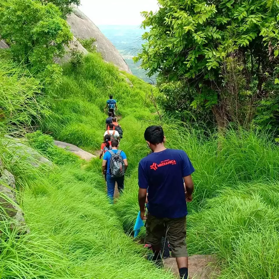

Bengaluru, the tech capital of India, is blessed with a unique geographical location. Bengaluru sits on the southern edge of the Deccan plateau. The altitude here ranges from 800 to 900 m above mean sea level. The high altitude and equidistant location from both west and east coasts makes the weather of the garden city pleasant throughout the year. The evening showers, which sometimes can get annoying, keep temperatures down even in the hottest summer months. The uniqueness of Bengaluru doesn’t stop here. While the city itself is based on a flat terrain, the surroundings are blessed with craggy, rocky hills. These hills are excellent trekking destinations and are perfect gateways from the humdrum of city life. The landscapes and flora and fauna are a visual treat for any nature lover. In this guide, we are going to take a tour of hills around Bengaluru. We are going to understand their geography and learn how we can plan to explore these hills on weekends.
The hills around Bengaluru can be divided into five clusters: Ramangara, Kanakpura, Tumkur, Chikballapur, and Kolar. Unlike Western Ghats, which form a contiguous range of more than thousand km, these hills are considerably isolated from each other. They pop out suddenly on a flat terrain and instead of forming a range, they stick around in clusters. The undulating landscape created by these clusters have become biodiversity hotspots. Some of these hills have religious significance, while others are protected wildlife areas. Nonetheless, these hills are natural and cultural treasure trove of Bengaluru.
Ramanagara cluster
Let’s begin with a cluster that is nearest to Bengaluru. Ramanagara is around 60 km from Bengaluru, on the Bengaluru-Mysore Road. The river Arkavathi cuts through this cluster. The average elevation of these hills is 1000-1200 m above mean sea level.
Ramadevara Betta
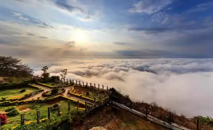
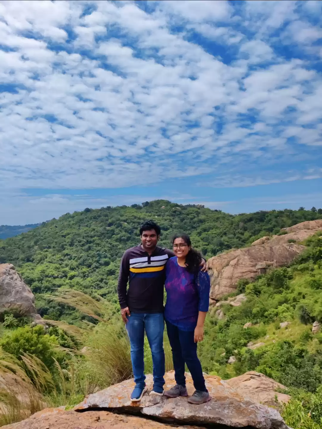
This is the most popular place in this cluster. The blockbuster Bollywood film Sholay was shot on this hill. There’s a small Rama temple on the hill. A paved path leads you to the temple. A trail from behind the temple goes further to the top of the hill. This is where adventure begins. The trail, which is mostly through grass, shrubs, and small rocks, suddenly takes you to a sheer cliff. Knee-high steps are carved on the cliff to help you get to the top. A railing is also provided to make the climb easier. Once you are on the top, you are blessed with mesmerizing views of the Arkavathi basin. On one side, you can spot the Bengaluru-Mysore highway cutting though fields and grassland. On the other is the vast expanse of scrub forest. These hills are marked as a vulture sanctuary. Keep binoculars handy in case you spot these winged beauties gliding around.
Distance from Bengaluru: 60 km
Difficulty level: Easy
Time for ascent: 45 min to 1 hour
Kungalu Betta
This unexplored hill lies on the east side of Arkavathi. A paved, winding road takes you almost to the top. Then an unpaved road leads you further. If you are on a bike, you can enjoy an off-road ride on this stretch. Finally, the climb begins. A mere ten-minute climb brings you to a small plateau where a giant Nandi overlooks the valley. You can enjoy the lush green landscape of Arkavathi valley from here. Further to this point, comes the most interesting part of this trek – a trail going through a cave! You crawl through a cave to reach the summit. The cave isn’t very dark or scary. In fact, tiny streams of light squeezing through crevices create a dramatic lighting effect inside the cave. Once out of the cave, you can reach a Hanuman temple and then further to the highest point of the hill. The climb is easy, and views are mesmerizing. Moreover, unlike Ramadevara betta, this place is hardly visited by any. Being deserted at most times, going here solo is not recommended.
Distance from Bengaluru: 54 km
Difficulty level: Easy
Time for ascent: 30-45 min
Thimappana Betta
This small hill with a temple is located near Kootagal, a small village around 10 km from Ramanagara. You can drive almost to the top of the hill. A small temple with a water tank sits on the top of this hill. From here, you can enjoy beautiful views of the surrounding villages and hills. The hilltop is a granite plateau with slight undulations. You can even ride a bike on this hilltop provided you have sufficient experience with off-roading. If you don’t wish to ride on the rocks, you can choose to walk around and explore the area. The most interesting thing about this hill is a pair of pillar-shaped rocks locally known at Jodi Bandegalu. These twin rock pillars stand isolated from the surrounding hills. Formed out of erosion, the granite pillars offer a beautiful frame for landscape photography. The place is particularly beautiful around sunrise or sunset.
Distance from Bengaluru: 59 km
Difficulty level: Easy
Time for ascent: 10-15 min
Kanakpura cluster
Kanakpura is a town between Bengaluru and Mysore, offering an alternative route to travel between the two cities. The Kanakpura cluster of hills is close to the Ramanagara cluster, and both these clusters can together be called as Arkavathi basin hills. However, this cluster is better accessible from Kanakpura than from Ramanagara, thus making it convenient to be considered a separate cluster. Apart from the destinations mentioned below, this cluster has Bheemankindi, Bilikal Rangaswamy Betta, and Achalu betta, which are also some good hiking destinations.
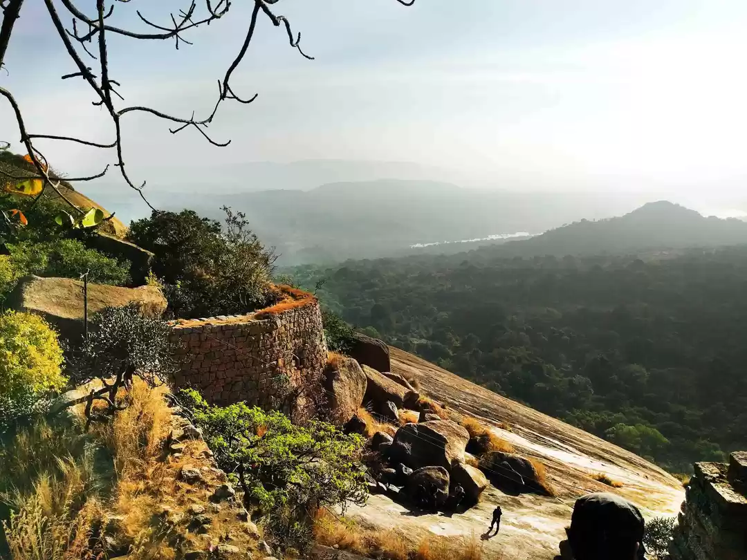
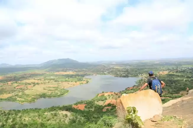
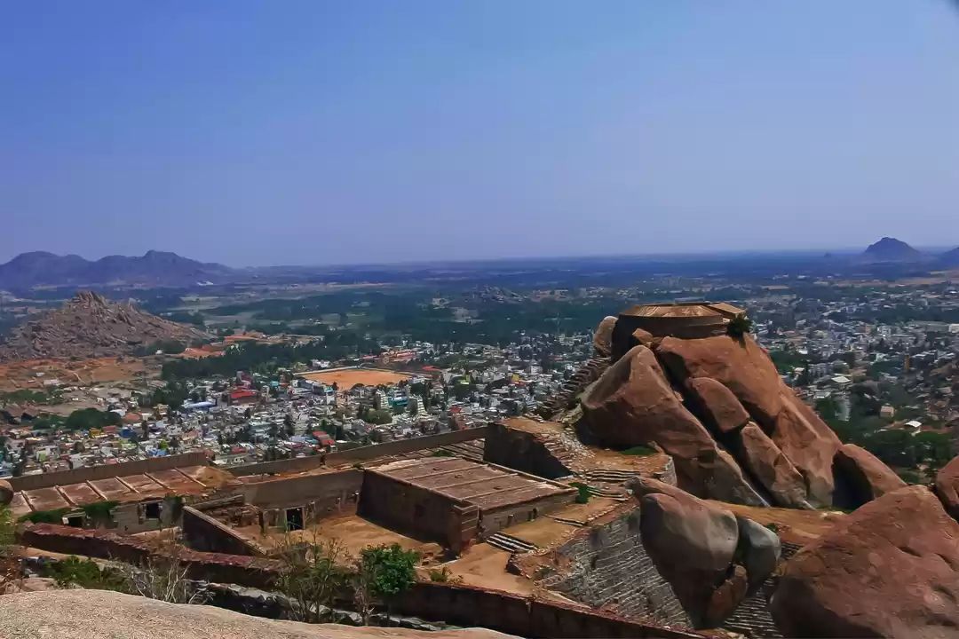
Kabbaladurga
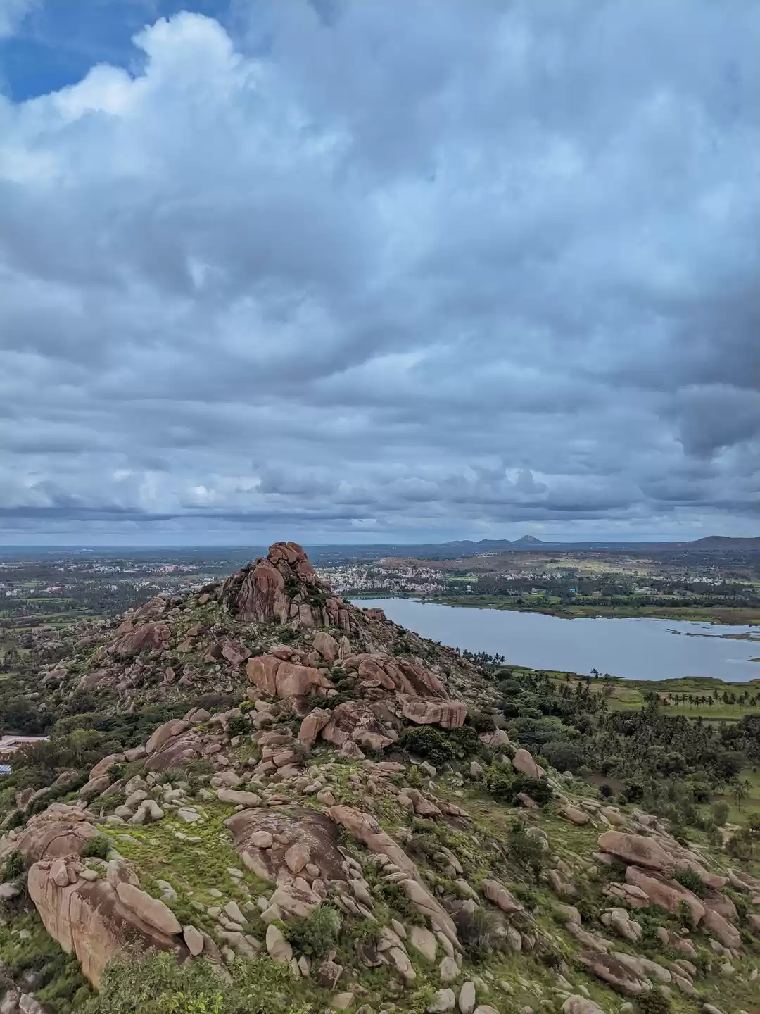
Situated around 20 km from Kanakpura, this pyramid-shaped hill offers spectacular views. Kabbaladurga is famous for the temple of Kabbalamma. Ruins of an old fort also lie scattered on the hilltop. The hike begins from a vast expanse of granite. After some patches of greenery, it suddenly takes you to a steep ascent. Steps have been carved on this ascent to help trekkers as well as pilgrims climb the hill easily. After crossing this steep ascent, you are greeted with a trail zigzagging through huge rocks and thorny bushes. Finally, you reach the hilltop where the temple stands tall. The hilltop is rather small. The southern side of the hilltop offers spectacular views of the valleys and hills of the Kanakpura cluster. Avoid summer months as there’s absolutely no shade on most of the hiking path.
Distance from Bengaluru: 80 km
Difficulty level: Moderate
Time for ascent: 2 hrs
Bananthimari betta
Most of the hills around Bengaluru have a temple on the top. Bananthimari betta, as the name suggests, is not an exception. However, the temple on this hill is not on the top but in the middle. Just a couple of kilometers after Kanakpura, a rightward diversion takes you to this hill. The road until the temple is motorable. Beyond the temple, you must make use of your legs. This hill is much larger than other hills in this cluster. The trail goes through a bamboo forest and then a grassland. As you near the summit, a sudden steep ascent on exposed granite takes you to the summit. Spectacular is an understatement when it comes to the landscape you see from the summit. The spot from where you see three ponds in one frame is like a cherry on the cake. Make sure you take your camera along to capture these beautiful frames. There’s an alternative route to this hill, which is accessible from Kanakpura-Ramanagara road. Ask locals for directions. Hiring a local guide is recommended as the forest is considerably dense and there are high chances of getting lost. There’s considerable wildlife presence in the region. Please be cautious while hiking.
Distance from Bengaluru: 80 km
Difficulty level: Moderate
Time for ascent: 2 hrs
Tumkur cluster
Tumkur has emerged as a satellite town of Bengaluru. Blessed with almost similar climate and geography and fast, efficient connectivity, Tumkur holds a bright future as a livable city. Along with these plus points, Tumkur has a massive cluster of hills and forests in its backyard, making it even more attractive destination. In fact, most of the easy hikes around Bengaluru are in this very cluster. Among the clusters mentioned in this blog post, Tumkur cluster is the largest and most contiguous.
Devarayanadurga
Popularly known as DD hills, this hill fort is quite famous among weekend travelers of Bengaluru. A rightward turn after Dabbaspete on Tumkur highway takes you this fort. A narrow, winding road takes you to the top of the hill. From there you can climb the steps to reach the temple. If not, you can reach a small rocky expanse to enjoy the views. The most enjoyable part of this hill is the scenic road that cuts through a dense forest. If you ride a bike, the journey is even more enjoyable.
Distance from Bengaluru: 72 km
Difficulty level: not applicable as there are steps to reach the top
Time for ascent: 15-20 min
Madhugiri
Located around 40 km north of Tumkur, Madhugiri is one of the most iconic hiking destinations around Bengaluru. This hill is considered as the second largest monolith in Asia, which means the entire hill is just one, contiguous rock! Unlike other hills, this hill has not just a temple but also a fort. The fort was built during the Vijaynagara times. The fortification is still intact, and you can appreciate the architecture even today. The most interesting part of the fort is an observation tower built on top of a dome-shaped rock. The surrounding terrain is dry and arid, which renders this place a rustic vibe. The trail is considerably steep and passes through multiple walls of the fort. On the hilltop, you can find a granary, a small temple, and observation towers. The views are scenic from the top. You should plan to start hiking as early as possible in the morning. As the sun goes up, the rocks heat up, and climbing gets difficult. Make sure you have sufficient water and food. Avoid hiking in the monsoon season as the rocky slopes can get slippery in the rains.
Distance from Bengaluru: 100 km
Difficulty level: Moderate
Time for ascent: 2 hrs
Apart from these forts, Channarayanadurga, Siddarabetta, Nijgal betta, Makalidurga, Mandaragiri are some other hiking destinations in this cluster.
Chikaballapur cluster
Chikaballapur is a district that lies north of Bengaluru. It houses a rather spread-out cluster of hills. This cluster almost reaches the Karnataka-Andhra Pradesh border. Nandi hills, the most famous weekend destination of Bangaloreans, lies in this cluster. Skandagiri, another popular sunrise trekking destination around Bengaluru, also lies in this cluster. Bhoga Nandishwara temple, a temple famous for its architecture and peaceful premises, is located right at the base of Nandi hills. This region is full of vineyards and eucalyptus plantations. The hills and valleys are teeming with wildlife. Overall, this region is a perfect long drive destination around Bengaluru.
Avalabetta
Located around 20 km from Chikaballapur, Avalabetta is a temple hill offering spectacular views of the surrounding terrain. The winding road goes through a dense forest and takes you to the hilltop. However, this is not exactly the summit. From here, you must climb the steps to reach the Hanuman temple. From this temple, if you take a rightward trail, you reach the most photographed spot around Bengaluru. A rocky cliff hanging midair! This spot has been closed by the local authorities for safety reasons. So, do not try to be adventurous. If you continue climbing up from the temple, you reach the summit, which has another temple. From here, the views are picturesque, and the wind is soothing. Overall, this is a perfect alternative to Nandi hills, if you are looking for an easily accessible hilltop without much crowd and chaos.
Distance from Bengaluru: 93 km
Difficulty level: Easy
Time for ascent: 30 min
Gudibande fort
Lying at the northern edge of the cluster, Gudibande fort is a small hill fort with intact fortification. The drive to the fort is scenic. You can park your vehicle at the base of the hill and start climbing. Start as early as possible in the morning, as the trail is steep and exposed. The trail goes up through several fort walls and takes you to the hilltop. As expected, there’s a temple on the top and mesmerizing views of the surrounding terrain. The fort was built by Byre Gowda, a general of the Vijayanagara empire. The fort is famous for its unique rainwater harvesting system. It is said that there are 19 rock ponds at different levels of the fort, which could hold up 3 lakh liters of rainwater. After you finish the hike, you can visit Sabbanahalli lake, a beautiful reservoir amidst small hills.
Distance from Bengaluru: 92 km
Difficulty level: Easy
Time for ascent: 1.5 hrs
Apart from these destinations, this cluster has Skandagiri, Chandragiri, Brahmagiri, are Kauravakunuda, which are interesting hiking destinations.
Kolar cluster
Kolar, a district made famous by a Kannada movie, lies to the east of Bengaluru, sandwiched between Andhra Pradesh and Tamilnadu. The terrain here is extremely dry and arid. Nonetheless, this district houses some beautiful trekking destinations and religious sites. The hills in this cluster are isolated from each other. Anthargange is one of the most famous trekking destinations here. Moreover, Kolaramma temple and Kotilingeshwar temple are most visited spots in this district. Overall, the hills in this cluster are not just of natural significance but of religious importance too.
Kailasagiri
Located around 40 km from Kolar, near a town called Chintamani, lies an isolated rocky hill called Kailasagiri. The hill is famous for a vertical rocky cliff and a cave temple of Shiva. A winding road takes you near the temple. A ten-minute walk from the parking area takes you to the cave temple. The place is serene and picturesque. The sheer granite cliff above the cave temple is breathtaking. However, the most interesting part is the dirt track that takes you to the top of an adjacent hill. If you are riding a bike, this dirt track can give you an amazing off-roading experience. Once at the top, you can see a vast plateau and unsurprisingly, a small temple. From here, you can climb to the summit. This half-an-hour hike offers spectacular views of the Chintamani town and surrounding hills. At the summit, there are ruins of an old fort and another small temple. The hike is easy but not advisable in rainy or windy weather.
Distance from Bengaluru: 88 km
Difficulty level: Easy
Time for ascent: 30 min
Avanibetta
Avani is a small village around 20 km from Kolar. It is famous for a historic temple and a small rocky hill. This small hill, known as Avani Betta, is an interesting hiking destination. It is believed to be the birthplace of Lav and Kush, the twin children of Rama. Upon reaching Avani, you are first greeted by a massive Gopuram of the Ramalingeshwara temple. This Shiva temple is believed to have been built by Rama himself. The temple complex is huge and offers spectacular frames for architecture photography. If you turn rightward from this temple, a paved trail takes you to the top of Avani Betta. Once you climb these rocky steps, you reach a plateau, which is believed to be the Ashram of the sage Valmiki. This is where the sage provided shelter to Sita during her exile. From here, you can go forward to the summit, which houses another temple and some beautiful views of the surrounding terrain.
Distance from Bengaluru: 98 km
Difficulty level: Easy
Time for ascent: 45 min
After going through this post, you must be wondering why famous places like Savanadurga, Makalidurga, and Huthridurga are not mentioned here? Geographically, these hills do not come under any of these clusters. Moreover, as they are well known, sufficient information is available on the internet. In this post, I have touched some lesser-known spots, which are equally beautiful and less crowded. The list is comprehensive but not exhaustive. If you know any more such destinations, please do mention in the comments below. Happy hiking!


' fill='%23359391'%3e %3cpath d='M46.1538462%2c43.5714286 L41.5%2c50 L36.8461538%2c43.5714286 L36.8670256%2c43.5714286 C36.3173077%2c42.7142857 36%2c41.6851429 36%2c40.5714286 C36%2c37.4854286 38.4535641%2c35 41.5%2c35 C44.5464359%2c35 47%2c37.4854286 47%2c40.5714286 C47%2c41.6851429 46.6826923%2c42.7142857 46.1329744%2c43.5714286 L46.1538462%2c43.5714286 Z M41.4294872%2c39 C40.6150641%2c39 39.9487179%2c39.675 39.9487179%2c40.5 C39.9487179%2c41.325 40.6150641%2c42 41.4294872%2c42 C42.2439103%2c42 42.9102564%2c41.325 42.9102564%2c40.5 C42.9102564%2c39.675 42.2439103%2c39 41.4294872%2c39 L41.4294872%2c39 Z' id='Location-white'%3e%3c/path%3e %3c/g%3e %3c/svg%3e)