


As I sat in a dhaba in Rangdum, a village in the middle of nowhere, drinking Cognac with a bunch of strangers, talking about nothing in particluar, happy and at peace with myself, I couldn’t help thank God for bringing me to Zanskar. Ever since our trip to Ladakh last year, we had every intention to return to the land of high passes. The beauty of the vast Changthang plateau haunted us, and we’d planned to visit it again this year. However, as this year’s trip came closer, a doubt crept into our minds - although there was no questioning our love for Changthang, visiting it again this year might make our trip too similar to the last one. Chanthang was not going anywhere, and we could always go back to it later. We decided that this year we would explore another part of Ladakh - the wild wild west. The plan was to restrict ourselves to everything west of Leh - explore under-construction roads, trekking routes with motorable/ jeepable tracks, and most importantly, the remote Zanskar. The travellers: Aarti & HarshThe machine: Our very own wild ass - Tata Safari 4x4 - affectionately called KiyangTotal distance covered: 3850 kms. A taste of things to come:
Day 1 (9th July): Delhi - Manali (580 kms, 12 hrs)Day 2 (10th July): Manali - Jam - 10m ahead - Jam - 10m ahead - Rohtang - Jispa (140 kms, 14 hrs)Day 3 (11th July): Jispa - Darcha - Detour - Darcha - Sarchu - Moreh Plains - Panginagu (260 kms, 13 hrs)Day 4 (12th July): Panginagu - Tso Kar basin - Debring - Leh (220 kms, 9 hrs)Day 5 (13th July): Leh, friends, dinners & permits. (20 kms)Day 6 (14th July): Leh, hospital, medicines, rest (50 kms)Day 7 (15th July): Leh - Nimmu - Chilling - Nimmu - Sham Valley - Part 1 of 2Day 8 (16th July): Lamayuru - Fotu La - Khangral - Chitkan - Dha - Batalik - Hamboting La - Kargil (150 kms, 6 hrs)Day 9 (17th July): Kargil - Rangdum Gompa - Juldo (150 kms, 10 hrs)Day 10 (18th July): Juldo - Padum - Karsha Gompa - Padum (140 kms, 8 hrs)Day 11 (19th July): Around Padum - End of Road-Zangla and Stongde (130 kms, 7 hours)Day 12 (20th July): Around Padum - Dzonkhul, End of road beyond Reru (135 kms)Day 13 (21st July): Padum - Kargil (230 kms, 11 hrs)Day 14 (22nd July): Kargil - Srinagar (230 kms, 10 hrs)Day 15: Around Srinagar - Wular lake & GulmargDay 16 (24th July): Srinagar - Jalandhar (475 kms)Day 17 (25th July): Jalandhar - Delhi (400 kms)
Day 1: Delhi - Manali (580 kms, 12 hrs)The night before the beginning of a trip is always a short one. It is almost impossible to put an over-active mind to rest and one twists and turns on the bed to fall asleep. So with limited sleep of just 3 hours, we finally left our flat in Vasant Kunj by 4 am. The high point of the drive till Bilaspur was the drive through Banur to avoid Chandigarh altogether. It must have shaved off at least an hour of our total drive till Manali. The road from Ropar till Kiratpur was also a pleasant surprise with the construction finally over and all flyovers complete. The lowest point, as is always, was the frustrating truck traffic between Kiratpur and Bilaspur. After driving non-stop for 6.5 hours from Delhi, we decided to stop for breakfast in Bilaspur. Breakfast at our usual stop, the Lake View hotel, was decent. Aarti then took over the wheel while I settled for some shuteye. Without any further incidents, we reached Manali by 4 pm. It was a record run for us till Manali, bettering our previous best run by at least half an hour. I wonder if Manali would be possible in 11.5 hours after the construction work on NH-1 is complete. As always, the next order of business was to reach Il Forno to have a late lunch. According to me, Il Forno serves not only the best pizzas in all of Himachal, but in all of India. Not to exaggerate, but the pizzas served even at La Piazza do not come close to the ones made by Roberta. You must give it a try when in Manali, if you love those thin crust non-oily pizzas like we do. The next course of action was to check in to “our” hotel, the Johnson’s Lodge at Manali. Since the HP govt. had decided to issue permits for non-HP registered vehicles to cross Rohtang, we had asked the hotel’s staff to arrange it for us. They had, thankfully, agreed to do so. That is when the owner dropped a bomb on us. She informed that Rohtang pass had been closed for a couple of days now, and that no vehicles had been crossing over. Our primary reason for doing a Zanskar centric trip via Manali, and not via Srinagar which would have made more sense, was to experience the Manali - Leh highway while going up, a thing that we had missed the last time around. Not ones to easily give up, we thought it would be best to speak to a couple of taxi owners on the Mall road before taking any further action. Meanwhile, as Aarti was busy checking in, I thought of making some good use of the light to capture the beautiful flowers in the garden near our room. A walk to the Mall road soothed our nerves a bit when we were informed that the pass is partially open with only jeeps able to make it through, and that too with much difficulty. What was reassuring was that it was at least POSSIBLE to cross Rohtang, although difficult. After arranging for breakfast and filling up the tank, we went back to the hotel to hit the sack as early as possible. We knew that we must push off from Manali early the next morning to beat the morning rush. What we did not know, however, was that we had a very long and frustrating day ahead of us.

Day 2 (10th July): Manali - Jam - Rohtang - Jispa (140 kms, 14 hrs)The day began on a wrong note altogether - no water in our room’s bathroom. And mind you the room was not cheap at 2500 bucks. I have my doubts if we’ll stay there again. Aarti, who has been in love with that hotel for many years now, of course disagrees. Anyway, after running about and finally managing somehow, we left for Rohtang at 4:30 am. Satisfied that despite the water fiasco we did not get too late, we began the familiar climb to Rohtang. Much to our surprise, our permit was duly checked at Kothi by a policeman, who was wide awake even at that early hour. We reached Marhi by 6 am, and the road till there was excellent. However, that was the end of our good luck for the day. I got out and walked a bit further, and then came back to tell Aarti that it was going to be a long day, with an initial estimate of 6 hours. In the next 8 hours, we moved about 4 kms. In between the intermittent crawling, we chatted with the trucks walas around us, napped and ate chips, cursing Rohtang all the while. An interesting conversation also happened with a fellow BCMTian, Sachin (airwolf9211) who was also stuck in the jam in his Scorpio. He told me about his escapades in the interiors of Changthang and driving on roads that we crave to explore one day. Some people are just lucky to have their work lead them to places like these. 7 hours later, we finally reached the spot which was the root cause of the massive jam. The slush at Rani Nallah and before it was the worst we’d ever seen, and no car crossing the ugliest 100 m stretch was able to make it in one go. A dozer was stationed nearby, which was helping, rather towing out all the vehicles from the slush. It was literally pushing the trucks out of the slush when they eventually got stuck after a futile momentum run. The poor taxis, however, were the worst hit. There was hardly any traction and pushing an Innova with a dozer would not have been the best of ideas. It was a royal mess, and although tired, we did not get frustrated and overall took the jam pretty well. Our destination for the day was Sarchu, but it soon dawned on us that there was no way we were going to make it there, lest we did some part of the drive post-sunset. This, however, was not an option as we wanted to take in the highway as much as we could in daylight. We re-evaluated our plan, and decided to stay the night at Jispa. The plan was to reach Leh in 3 days from Manali and somethings would have to go off our itinerary in order to make up for the lost 8 hours. Well, that’s the Manali-Leh highway for you, even the best laid plans have to be changed at the last moment. And I guess that’s the beauty of it all. We somehow made it to the top by 2:30 pm, after having crossed the final slushy stretch in one go, all thanks to the 4L mode that Safari offers. What was surprising though was that even with a 205 mm GC, some stones did hit the underbelly of our car. After a quick stop at the pass to check for leakages beneath the vehicle, we proceeded towards Jispa. Rohtang’s descent was much better than its ascent. The road was not good, and was ridden with potholes, but at least it was not slushy. A fabulous lunch of meat curry and rice happened at Koksar, the lovely, windy village after Gramphoo, known to be the coldest place in Lahaul. Thereafter, the road was like a runway, and even the fifth gear saw light of day! A few kilometers after Koksar, just before Sissu, we saw the mouth of the Rohtang tunnel on the other side of the Chandra river, the sight of which, after the 8 hour ordeal we’d been through earlier in the day, was very pleasing. Aarti promised God that she would distribute sweets and also come to Manali the very day the tunnel opens. For the first time, I agreed that Rohtang was not worth all that pain. After ogling at the tunnel for a bit, we went on. After a quick refuelling stop at Tandi, we moved on towards Keylong. We tried to log on to the net and also call a few people to update them about our freedom from the horrible jam, but the network was patchy, and we couldn’t. We finally reached Jispa around 6:30 pm, and headed straight for the Padma Lodge, where we’d stayed way back in 2008 when it was still under construction. After checking in, we went down till the river, and were totally floored by its beauty. The way the beautiful Bhaga spreads out at Jispa is stunning. The icing on the cake was the early moonrise, which captured the attention of our cameras for quite sometime. The Padma Lodge is a lovely place with nice and clean rooms, and a charming dining room on the first floor. And guess what, it does serve beer for those who are interested . The Lodge has two buildings, and both are almost equally priced. We got to know later that Rahul Gandhi had done the Manali - Leh highway last year, and stayed at the same lodge.

Day 2 (10th July): Manali - Jam - Rohtang - Jispa (140 kms, 14 hrs)We re-evaluated our plan, and decided to stay the night at Jispa. The plan was to reach Leh in 3 days from Manali and somethings would have to go off our itinerary in order to make up for the lost 8 hours. Well, that’s the Manali-Leh highway for you, even the best laid plans have to be changed at the last moment. And I guess that’s the beauty of it all. We somehow made it to the top by 2:30 pm, after having crossed the final slushy stretch in one go, all thanks to the 4L mode that Safari offers. What was surprising though was that even with a 205 mm GC, some stones did hit the underbelly of our car. After a quick stop at the pass to check for leakages beneath the vehicle, we proceeded towards Jispa. Rohtang’s descent was much better than its ascent. The road was not good, and was ridden with potholes, but at least it was not slushy. A fabulous lunch of meat curry and rice happened at Koksar, the lovely, windy village after Gramphoo, known to be the coldest place in Lahaul. Thereafter, the road was like a runway, and even the fifth gear saw light of day! A few kilometers after Koksar, just before Sissu, we saw the mouth of the Rohtang tunnel on the other side of the Chandra river, the sight of which, after the 8 hour ordeal we’d been through earlier in the day, was very pleasing. Aarti promised God that she would distribute sweets and also come to Manali the very day the tunnel opens. For the first time, I agreed that Rohtang was not worth all that pain. After ogling at the tunnel for a bit, we went on. After a quick refuelling stop at Tandi, we moved on towards Keylong. We tried to log on to the net and also call a few people to update them about our freedom from the horrible jam, but the network was patchy, and we couldn’t. We finally reached Jispa around 6:30 pm, and headed straight for the Padma Lodge, where we’d stayed way back in 2008 when it was still under construction. After checking in, we went down till the river, and were totally floored by its beauty. The way the beautiful Bhaga spreads out at Jispa is stunning. The icing on the cake was the early moonrise, which captured the attention of our cameras for quite sometime. The Padma Lodge is a lovely place with nice and clean rooms, and a charming dining room on the first floor. And guess what, it does serve beer for those who are interested . The Lodge has two buildings, and both are almost equally priced. We got to know later that Rahul Gandhi had done the Manali - Leh highway last year, and stayed at the same lodge.

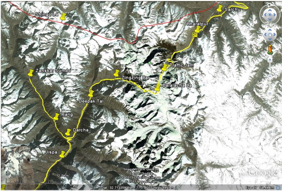
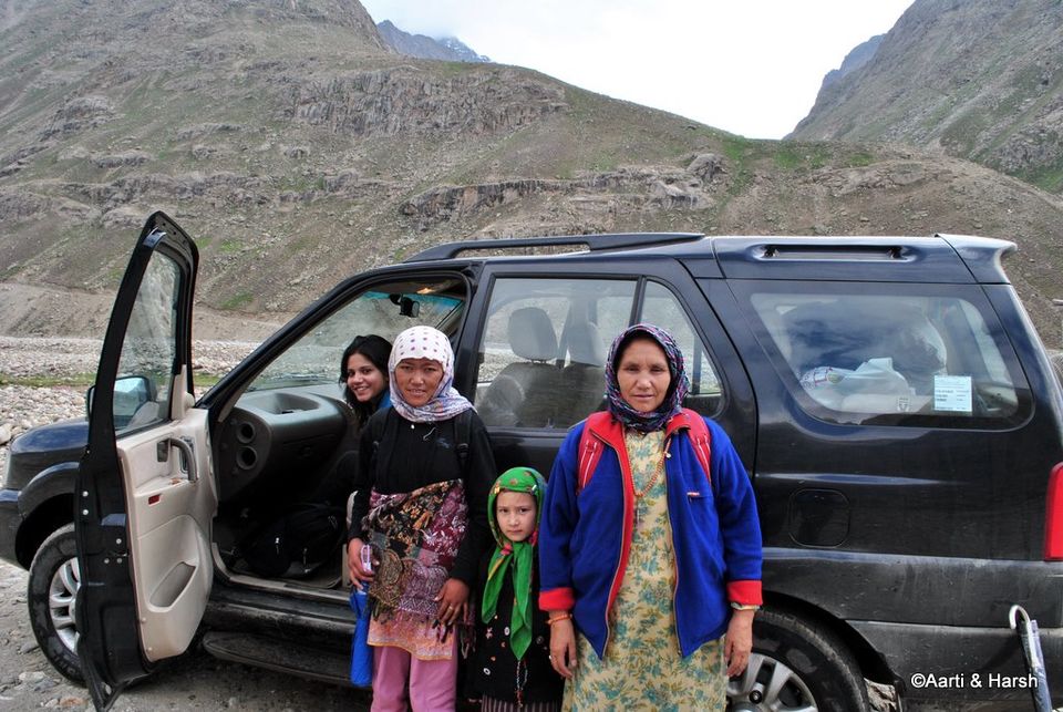
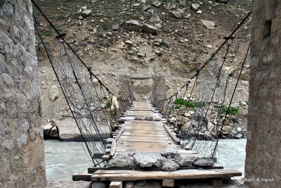
Day 3 (11th July): Jispa - Darcha - Detour - Darcha - Part 1Day 3 had to have an early start. We’d lost 8 hours the previous day, and were determined to make up on the lost time. Jispa looked ethereal in the early morning light, and we had to steel our hearts to leave it in a hurry. We wanted to reach Sarchu for an early lunch, and planned to camp that night either at Debring or at Tso Kar.As we crossed Darcha, we came to the cut which marks the beginning of the Darcha-Padum trek route. We stopped and mulled over our obvious curiosity to check out till where the road was complete. We’d anticipated this, and knew that if we took this detour, all our plans would again go awry. But as we all know, curiosity killed the cat, and in this case the cat was our plan. So we took the turn and rolled on. A few kilometers after the cut, we came upon the beautiful twin villages of Chikka and Rarig. Moving further, we came to a tiny hamlet with a couple houses by the name of Palmao, which was also a makeshift BRO camp where construction related work was on in full progress. A few meters ahead, an old lady, a young girl and a little girl waved to us for a lift. As we drove along with them towards the end of the road, they told us that they live in Kargiak, a village across the Shingo La. From Zanskar Sumdo, which marks the end of road for now, it would take them another 3 - 4 days to reach their village. They had come to Manali for some work, and were now going back. We asked them why they had not taken the Kargil - Leh - Manali route, because although longer, it is much more convenient as there is a road all along the route, and the trek from Kargyak to Padum would not be very difficult, being a relatively flat walk. But the old lady said that that makes the trip very expensive, and they prefer to trek and save that money. What we consider a ‘difficult’ trek is taken head on by these brave locals without even a tent! Respect!Zanskar Sumdo is about 20 kms from the Manali-Leh highway and takes about an hour. The literal end of the road was marked by a bridge over the Barai Nallah. The Nallah had accompanied us throughout, and drains itself into the Bhaga at Darcha. This bridge was only for people on foot, and was not meant for vehicles. However, on the other side of the river, we saw that a couple of switchbacks had been blasted, where a dozer and a blasting machine were parked. We wondered how those crossed the river, and then saw tyre marks on the bank of the river at a place where the embankment was not high. We then realized why no one was working on the road now - the only way for machines and material to cross the valley was through the river, and it was monsoon time now when the water was too much to allow crossing. It is indeed a marvel how BRO manages to construct excellent roads under such constraints and in such difficult terrain.We crossed the bridge, which has to be the ricketiest bridge we’ve ever crossed in our lives. It swayed like crazy while we were on it! The view from the other end was spectacular, and we just stood gazing at it for a few minutes. Oh what fun it is to see the end of roads!It was 9’o’clock already and our stomachs were beginning to rumble! We decided to have some breakfast at the tiny dhaba there where the family to whom we’d given a lift were also snacking. Over chai and Maggi, the owner of the little shack told us how difficult life was for him, and how desperately he was waiting for the Darcha - Padum road to get completed. It would bring more business, more tourism and overall prosperity to the region. Not to mention a much better level of medical facilities in case of emergencies. After a hearty breakfast and exchange of lots of stories, we said our goodbyes and moved on. It took us about an hour to reach the Manali - Leh highway. Once the road to Padum is complete via Shingo La, Zanskar would be a two day drive away from Delhi. The detour to Zanskar Sumdo had been completely worth the 3 hours spent on it. However, even now, a full day of stupendous scenes awaited us. The exquisite plains of Sarchu and Moreh never fail to awe and shock, even for returning visitors on this highway to heaven.

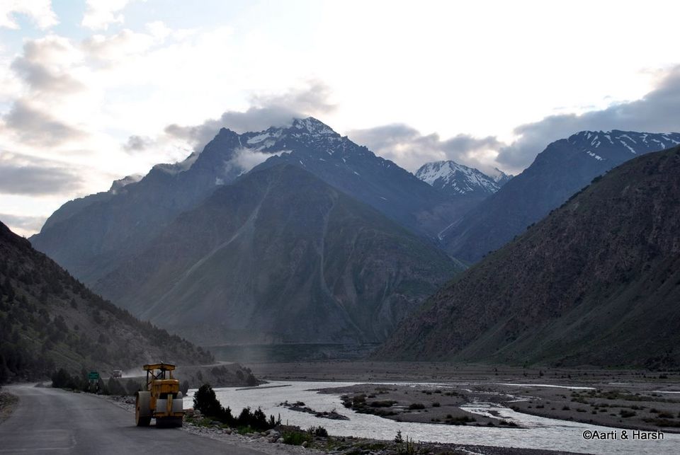
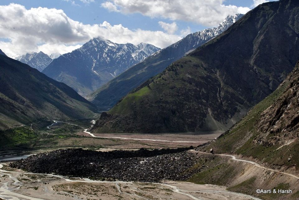
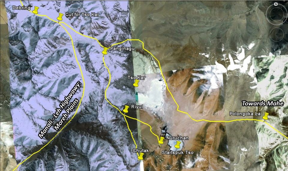
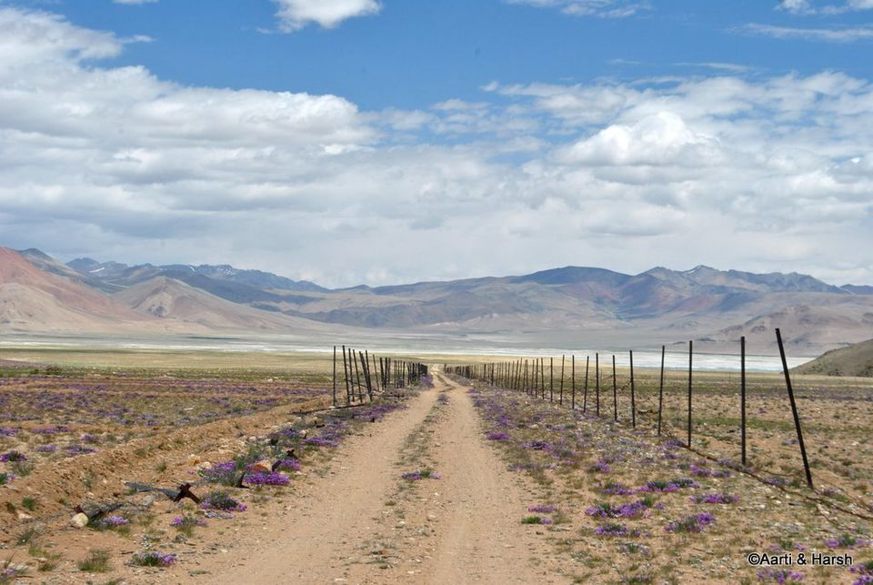
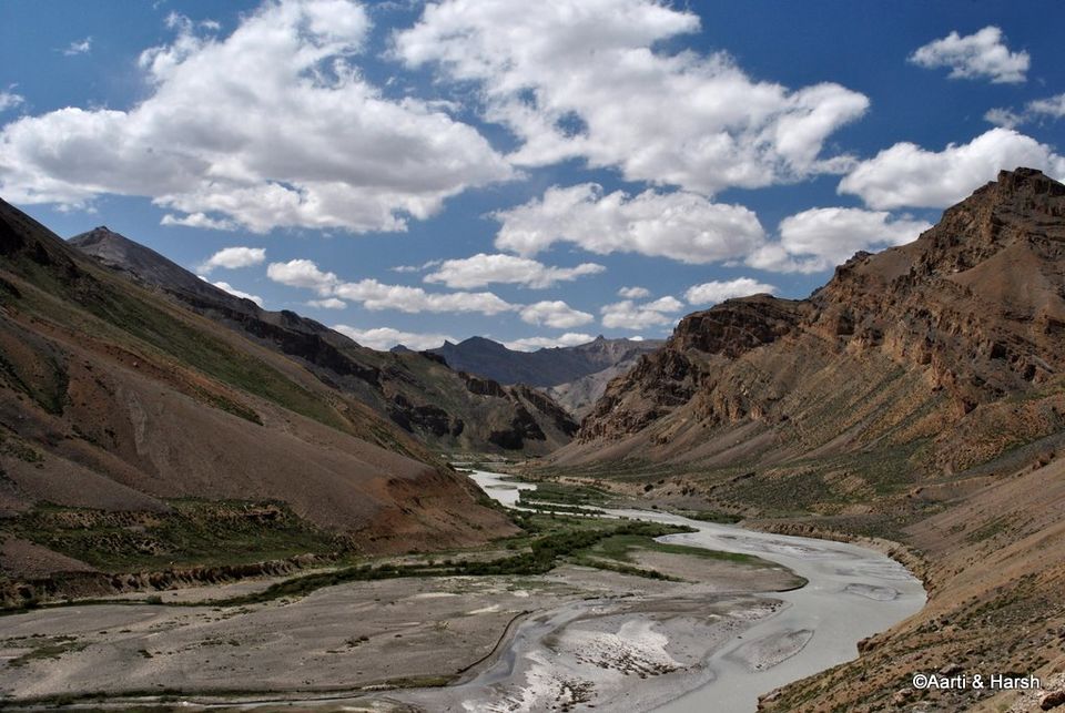
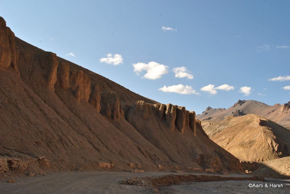
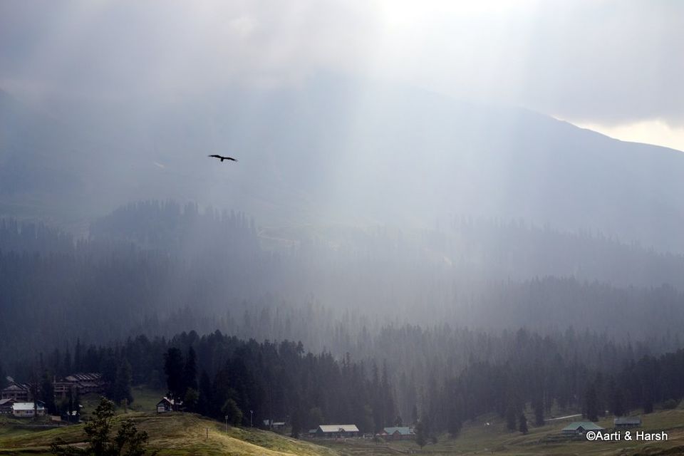
Day 3: Darcha - Sarchu - Moreh Plains - Panginagu (260 kms, 13 hrs)The Sarchu plains extend for quite a while even after the tents. One follows the Tsarap Chu and crosses over a bridge over one of its many tributaries till the ascend of the Gata Loops begin. A little known fact about Tsarap Chu is that it originates somewhere in the Spiti region a little North of Losar, with tributaries also coming in from Baralacha La (Yunam river) & Phirtse La (Lingti Chu, near Kargyak village in Zanskar). The Yunam river and Lingti Chu join somewhere when we descend the Baralacha La, to eventually join Tsarap Chu after the Sarchu tents. From here we leave the river at Gata Loops to continue our journey towards Leh. The river itself twists and turns, including twin U-bends, crosses the Phutgal Gompa and eventually joins the Kargyak Chu to form what we know as Tsarap Lingti Chu. This eventually drains into Doda (Stod) river a little after Padum to form the mighty Zanskar. Phew! So theoretically, if one gets into a raft at Sarchu, they could go all the way into Pakistan and drain out into the Arabian Sea near Karachi!As compared to this long journey of Tsarap Chu, we continued our smaller journey towards Leh by climbing the Gata Loops. I unfortunately could not take any shortcuts on those bends, thanks to Aarti’s wish to COUNT all the 21 loops! So 21 hairpin bends and lot of frustration later, we reached Nakee La. A short descent from the pass, and then one starts the gentle climb to reach the next pass, Lachulung La. Thankfully, this time around I convinced Aarti not to stay on the road, and allow me to take a shortcut, basically do an off-the-road climb. Needless to say, it was good fun. After spending a while at the pass and chit-chatting about the climb to Marsimek La with an NIOC guy who was in a Gurkha with his wife, we moved on. While descending from Lachulung La, we spotted some Bharals at the very same spot where we’d seen them last year. This gang of Bharals also had some kids in it, and they were curious enough about us to pose for some nice shots.The most dramatic stretch of the Manali - Leh highway starts after Lachulung La. The road mostly runs along the river Lachulung Lungpa, at times almost level with it, and the mountains on either side seem as barren and as majestic as ever. One truly feels dwarfed by the magnitude of the landscape around. The notorious Kangla Jal is not much of a nuisance anymore, with the road having been cemented and also made broader at that point. We then climbed a bit, crossed a mountain, and then descended again to cross a pretty looking bridge. The valley opens up a bit after this, and one can spot the famous landmark, the wind-carved archway, which warrants a photography break. Hoodoos, the weird structures formed as a result of continuous wind erosion, come up next, and all one can do is sigh and revel in the beauty of the vista around. And this is when one knows that the stupendous Moreh Plains are up next!As we ascended to Pang, we could hardly control our excitement to see the Moreh Plains. However, when Aarti saw a souvenir shop at Pang, all excitement was postponed, and off she went to shop. Thinking that this would take care of most of her shopping for the trip, I too went in to help. This clever thinking helped me save at least half a day of shopping at Leh. God bless the army for bigger things and even smaller pleasures such as these. The shop had closed for the day, but the army men in charge showed us the stuff. After buying all kinds of souvenirs ranging from beer mugs to table clocks, we finally got back into the car and drove on.There are very few sights that can overwhelm you as much as the vast Moreh Plains unfolding before your eyes after Pang. It is as if you suddenly come upon a flat table top, and can simply not see the end of the table! Just as one enters the Moreh Plains, the view from the edge of the plateau of the Sumakhel Lungpa river winding through the valley beyond is simply beyond words. We decided to not drive on the road on the Moreh Plains, and for quite a while drove parallel to the actual road. However, once the stretch we were driving on turned marshy, we had to quickly join the road, which right now is still under construction, with diversions every 200 meters. It was 7:15 pm by now, and we had just taken the decision to camp at Debring, about 15 kms away, when we came across a sign board about a camp just 3 kms from the road in Panginagu, next to Tso Kar.
We were tired and in no mood to pitch our own tent (it is not the easiest tent to pitch), and quickly decided in favour of going to Panginagu. The thought of spending the night next to the beautiful Tso Kar was also quite tempting. Although the board mentioned it to be 3 kms away, even after 5 kms, we could not see any sign of the camp. A feeling that was quite similar to the one we experienced last year at Tso Moriri dawned upon us. A feeling of going down the wrong path at dusk, with no option left but to pitch our own tent in the middle of nowhere. We were really not up for that today. Thankfully, we found the camp site after about 20 minutes, and were glad to see that they had nice and clean tents. Having our own tents did help us bargain immensely on the rates. It was slashed from 3000 bucks (including dinner & breakfast) to a reasonable 1200. After a nice dinner of noodles and baked beans, we retired for the night. It was cold, and we were also feeling a bit breathless. However, tiredness took over, and instead of popping a Diamox, which would have been the prudent thing to do, we just went off to sleep. At least Aarti did manage to sleep, while I simply tossed and turned. For the first time AMS hit me, and it was a long, restless night resulting in a complete change of plans for the next day...

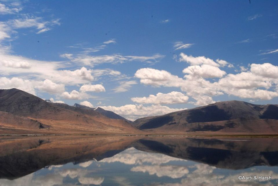
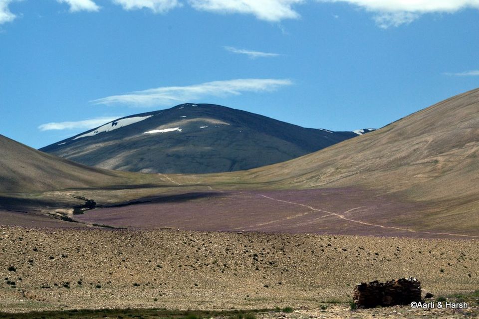
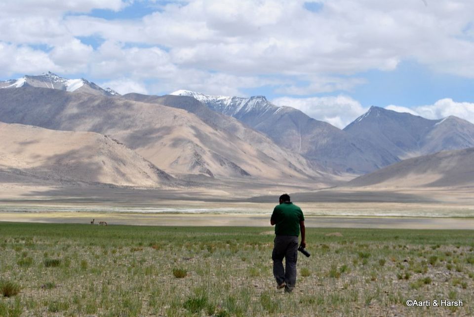
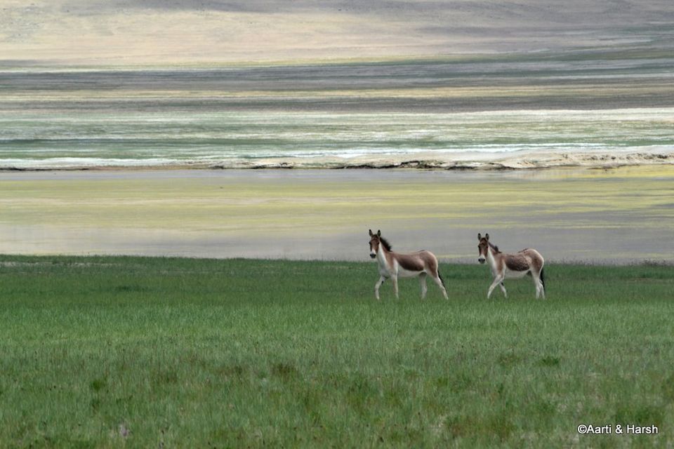
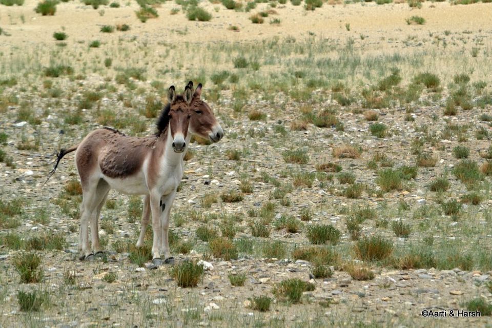
Day 4: Panginagu - Tso Kar Basin - Debring - Leh - Part 1 of 2A note before you proceed reading:Kiang = A wild ass, whose home is the cold desert of Changthang. Kiyang = A wild Tata Safari, whose home is New Delhi, at times found in the cold desert of Changthang. The night before had been terrible. I could not sleep at all, was feeling cold throughout, and to top it all I also had an upset stomach. We’d planned to leave at 5:30 in the morning to explore the Tso Kar basin and come back to the camp for breakfast. Then we had planned to go to Yar La and Datgo (the Rupshu region) before lunch, before finally heading off towards Leh. Although we did wake up at 5:00 am, I was in no position to go, having not slept a wink the previous night. We went back to sleep, and only woke up at 8:30. Sadly, it was now too late to do both the Tso Kar basin and Yar La, so we decided to explore the former. Both our heads were throbbing badly, and we wanted to take it a bit easy. After a lazy breakfast, we finally moved from the camp at 10 am.The people at the camp had told us that the dirt track that led us there would go till the lake, but beyond that they had little idea till where it went. So far our tryst with the lake was from a distance, and naturally we were eager to get a closer look. As we moved ahead on the track, the pretty lake slowly came into view. We realized how big Tso Kar really was, and what a small bit of it we’d seen last year. Thankfully, there was hardly any wind at the time, and the lake was perfectly reflecting the mountains behind it. The lovely blue sky dotted with fluffy white clouds completed the perfect picture. We spent some time soaking in the vistas, before moving on. The Tso Kar basin is beautiful, and a large part of it was covered with purple shrubs this time of the year. These shrubs also grow on mountains, giving the whole landscape a purplish tinge. The fact that the place is a wetland only adds to its beauty. Soon we came to the tiny village of Riyul, from where the track bifurcated, one leading towards the lake and to the village of Nuruchan, and the other towards the end of the basin and to the village of Chutak. We opted for the latter, since we also wanted to glimpse the Startspuk Tso, having missed it last year. My hidden agenda was to check if the dirt-track went all the way till Kiagar Tso, had a hunch that it just might. For a change, the hunch was wrong and we did manage to hit a dead-end at the village Chutak. The outline of a village, which we now know as Chutak, appeared in the distance, and that is where the track was going. We hesitated a bit, since we wanted to circle the lake, but then curiosity tempted us to check out the village. All this while, we were hoping to spot a Kiang, as we had seen them last year in this very wetland, on the opposite side of the lake. Just as we were losing hope, we spotted two of them, and one crossed the track right in front of us. We were elated, and spent some time trying to capture the Kiang on camera, but did not get good shots as it soon ran away.As we neared the village, we saw that its boundaries were fenced. Inside the village, however, all we could see were locked houses, and not a soul around. We went up till the end of the village, which was also the end of the basin. The end was uncharacteristic, the terrain ahead was simple enough to have dirt-tracks and the climb ahead to Startspuk La seemed easy for a 4WD! However, there were no dirt-tracks. Not even signs of tyre tracks which we could follow. My hunch was thus rendered false, and we realized that the route from there to Kiagar Tso was only a trekkable one for now. We could still not see any person or animal around. Some houses had what seemed like pashmina goat wool on top of their roofs, but ALL of them were locked. We could not figure out if the village was abandoned or if the villagers had simply gone out to earn a living, which of course would mean grazing their flock!We then retraced our steps and went all the back till Riyul where the track had bifurcated. We now took the other path which led towards the lake and to Nuruchan. This path was much less used, and we sometimes even lost the tyre tracks for a few meters. It was also much closer to the lake, and hence we had to be careful not to veer off into any marshy areas or worse onto any part of the wetland. In the distance, we saw a watch tower, and concluded that this must be used by bird watchers to monitor the movement of migratory birds. Along the way, we spotted two or three brown spots far away, and on looking through the zoom lens figured that they were actually Kiangs. I even got down from the car to capture two of them on camera. As I was walking back, they too seemed to follow me. Then, they stopped pretty close to us, and stared. And stared. And stared. Took a graceful turn, in perfect coordination, and then stared. And stared. And stared. Took a graceful turn, in perfect coordination, and then stared. And stared... and so on! All this while, Aarti had been shooting furiously with the zoom lens, and even managed to shoot a video of their antics. We were bewildered by these two brave and bold Kiangs, so curious about us humans that they did not let us out of their sight even for a second. It was us who had to finally give up and drive away when we got the feeling that this cycle might actually go on the whole day! But indeed, the grace with which the Kiangs carry themselves is marvelous. Everything about them - their slender, athletic body, their beige and brown colour which completely blends into the barren surroundings, their cute, alert ears, their majestic mane, the way they run with their heads up - is beautiful. What elegant creatures! Needless to mention, we were absolutely thrilled with the attention we got from them. We also spotted the tiny Startspuk Tso in the distance. Both of us somehow love the name of that lake, and were glad to have finally seen it. Realizing that this track too did not cut across the lake, as marked on the map we had, we went back the way we had come. Some Brahmini ducks were frolicking on the edge of Tso Kar, but we couldn’t get good shots of them as they were very shy and flew away at the slightest indication of movement. We had almost reached our camp at Panginagu when we noticed some marmots on either side of the track, and were delighted at having spotted the one animal that we were really missing.

Day 5 (13th July): Leh, friends, dinners & permits. (20 kms)Our day of relaxation. We got up late and rushed to the DC’s office for our permits, only to find out that there was some local holiday because of which the office would only open after lunch. Disappointed, we made our way to the Pumpernickel German Bakery for some brunch. I was still not feeling totally fit, but did not give that much attention. After brunch, we decided to visit our favourite jacket shop to buy some new ones. Alas, while Aarti bought a new jacket, I couldn’t find the type I needed. We then went to the DC’s office again, which was now open. I filed for the permit, which was to be collected in 1.5 hours. We then went back to Old Fort Road for some lunch at The Tibetan Kitchen. Thereafter, I dropped Aarti at the hotel, collected the permit, and came back to join her. By this time, I was feeling quite sick, and on checking found out that I had a mild fever. Visiting a doctor was the next logical move, given our long and hopefully strenuous journey ahead, and so we set out for the Leh hospital. The hospital is run by the Government and is hence free. We had to pay a nominal charge of Rs. 2, and then went to see the doctor. She checked the oxygen in my blood and my blood pressure, all of which was okay. She then checked my fever, which had miraculously disappeared in the brief 20 minute journey from the hotel to the hospital. Since my stomach was also upset, the doctor concluded that I must have some stomach infection which caused the fever. What I definitely did not have was AMS, and both of us sighed in relief. The doctor advised us to stay in Leh for at least 2 more days before we pushed off towards Zanskar. She prescribed some medicines, which we bought from the chemist opposite the hospital. I was feeling much better already knowing that it was not AMS I was suffering from, but just some random stomach infection. The doctor had prescribed antibiotics, and I knew they would take care of the infection. I felt as good as new, and was all set for leaving the next day as per plan, but Aarti would not hear of it. She wanted me to rest and take it easy for one more day. And as you know, there is no way of winning an argument with a woman. So one more day in Leh it would have to be.We went out for dinner again with our friends that evening, though I stuck to some simple soup and bread. After wishing them all the best for their Stok Kangri expedition, we turned in for the night.Day 6 (14th July): Leh, hospital, medicines, rest (50 kms)It was supposed to be a rest day, thus the day began pretty late. A lazy breakfast on the lovely rooftop restaurant at our hotel saw us eventually head out by 11:30 am. Our friends had left for their Stok Kangri expedition early in the morning. I was technically supposed to rest, but felt completely okay and wanted to move about. We knew of a car washing place in Choglamsar where we’d been to last year, and headed straight there to turn Kiyang into black again from the dusty brown it had become. The guy there asked us to come at 2 pm, and so we decided to spend the time in between by going to the Stok village.We drove on on the Choglamsar road, and soon hit the road going to Stok. The view of the statuesque Stok Kangri right in front of us was stunning. What worried us though were the clouds on it. The peak could hardly be seen, and the weather around the summit seemed to be worsening by the minute. We knew that this could not be good for our friends, and hoped that they were okay. We went all the way up as the road would take us, took a U-turn and came back. Stok is a huge and very prosperous village, with abundant green fields and lots of Maruti 800s. After driving around for a while, we returned to Choglamsar to give Kiyang a good scrubbing. Thereafter, we went back to Leh, had a late lunch at the La Terrasse opposite the SBI ATM in the main market, and then eventually sat sipping tea on the rooftop of our hotel till late in the evening. With my health not acting up the whole day, we were pretty much set for an early departure the next morning. The real focus of the trip begins from day 7...

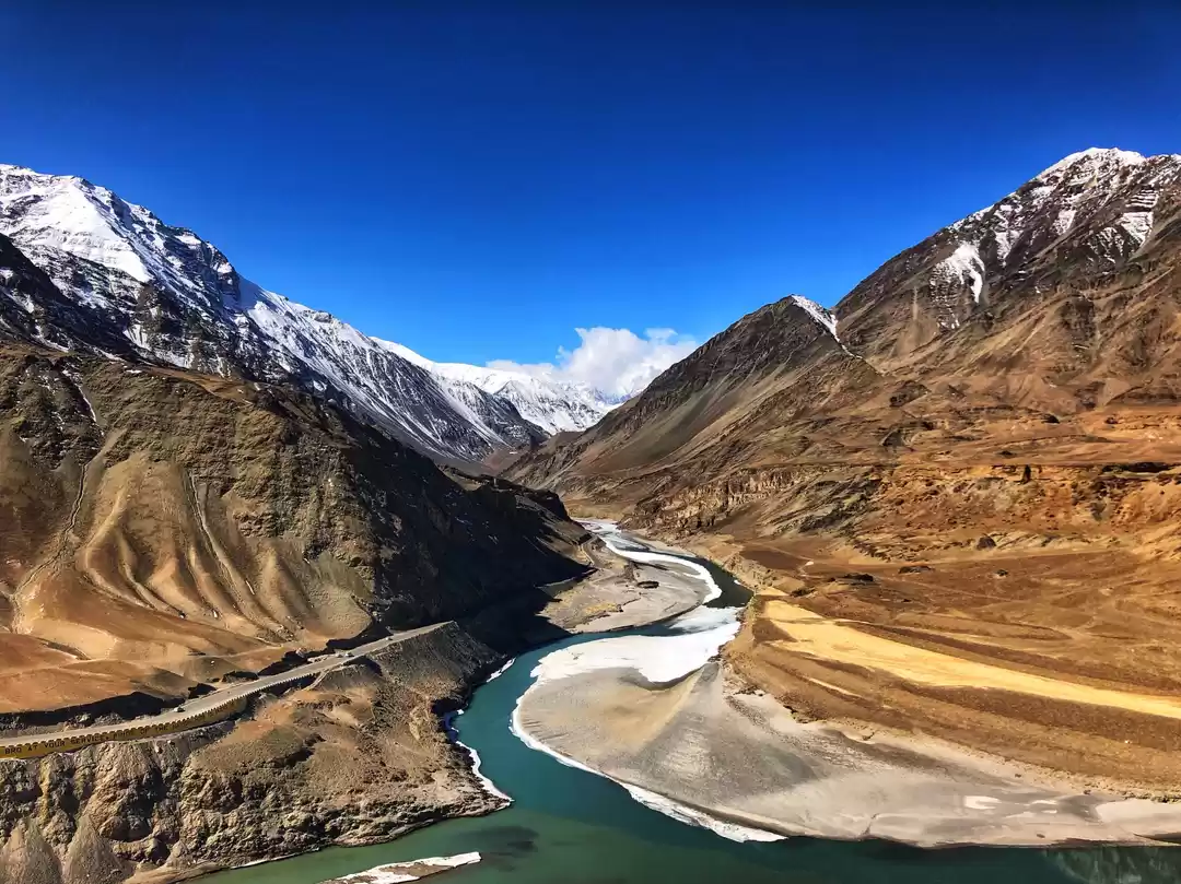
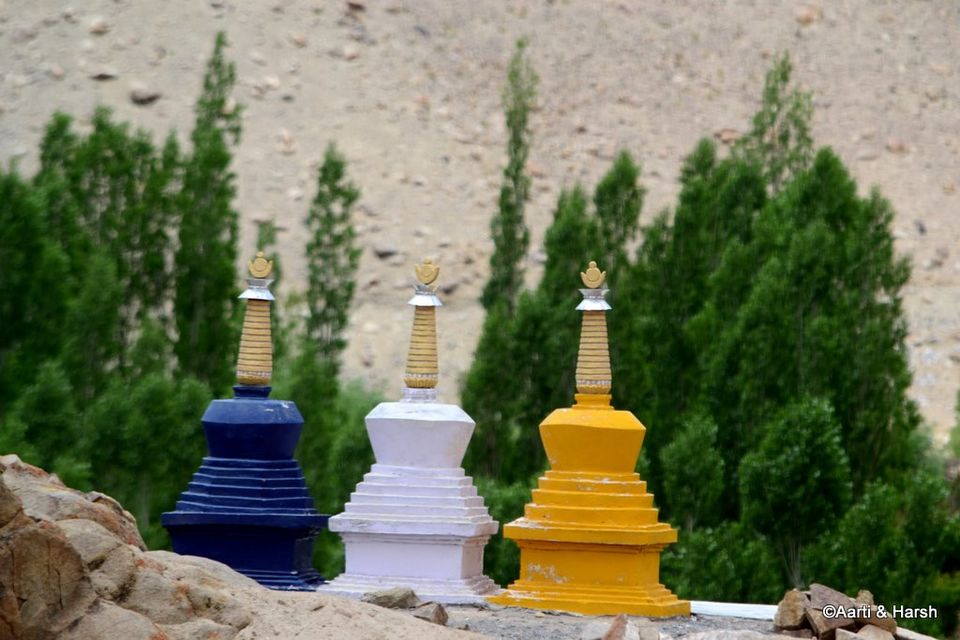
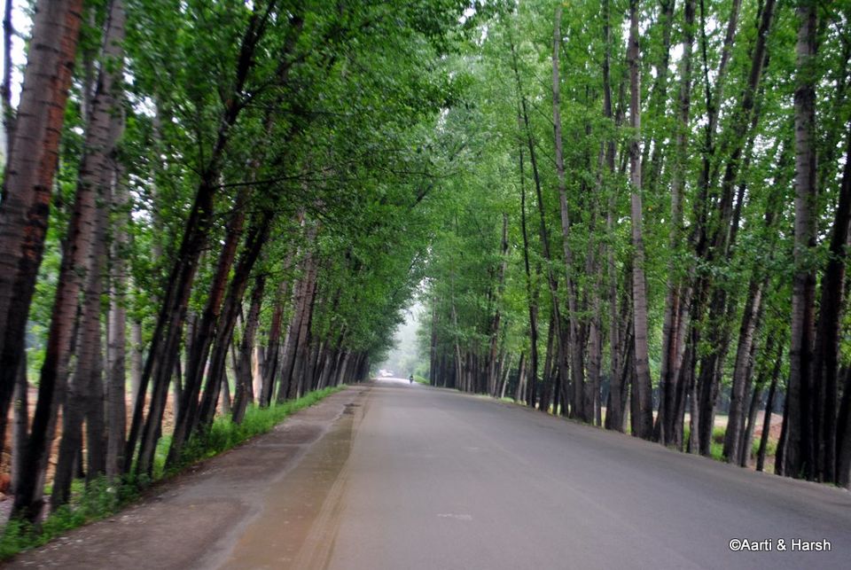
Day 7 (15th July): Leh - Nimmu - Chilling - Nimmu - Sham Valley - Part 1 of 2Day 7 was our day of ‘detours’, the day when we planned to explore all kinds of ‘motorable treks’, if that makes any sense. By detours we mean mostly exploring and going to ‘ends-of-roads’. All the detours were planned off the Leh - Srinagar highway. It was going to be a long day, but after two days of complete rest, we were upbeat and looking forward to some off-roading. We left our hotel at 6:15 am the next morning. In half an hour, after a quick stop at the gas station, we had reached the straight road after the Leh airport . The morning light made the landscape look heavenly, and hence our progress was slow. All flights landing in and flying out of Leh are scheduled for early in the morning because that is when the weather is most stable. We saw several flights landing, and enjoyed the sight of a lonely plane flying against the barren and majestic mountains.We did not stop at the Magnetic Hill to experiment this time, having already decided last year that it was an optical illusion. Soon, we reached Nimmu, and after photographing the confluence of the Zanskar and Indus rivers, we continued towards our first planned detour of the day - to Chilling and the end of road beyond it. The road to Chilling runs along the Zanskar river, in a very narrow and dark valley. It is actually more like a gorge than a valley, with cliffs jutting into the river. The mountains seem to be made of hard rock and give a very rugged appearance. The rock, they say, is also quite difficult to cut through, and no wonder a land-trek route does not exist on this stretch, and people have to walk on the frozen Zanskar river (the famous Chadar trek) in the winters to reach Leh from Padum. The mountains also get a purplish tinge here, and remind somewhat of the valley after Tanglang La. The ferocious Zanskar rives enthralls throughout, and one can just stare at the river for hours admiring its beauty. That is one river with a personality of its own!Chilling is 28 kms from the cut from the highway, the village not really on the road but a bit higher. There are some home-stays available at the village and some dhabas as well. However, when we reached Chilling, it was still too early for the dhabas to have opened. Beyond Chilling, we crossed a few groups of foreign trekkers on the way, probably doing the Markha Valley trek. The poor souls were trekking on what is now a motor-able road, it must sure not be fun anymore!We continued on the now not-so-good road, crossed a BRO camp, and finally after 10 kms or so reached a point where the road was blocked due to construction work. We could not go further, and on talking to the BRO officer overseeing the work, we got to know that the road had only been blasted another 2 kms from that point. On the way back, we saw the trail marking the beginning of the well known Markha valley trek on the other side of the river. The most surprising part was that the track seemed to be used by four wheelers, although there was no bridge over the Zanskar for four wheelers to cross! If someone could solve this mystery for me, I would be highly obliged, Avinash Sidhu probably? The trekkers, whom we had crossed earlier, were using a traditional pulley arrangement to cross the river one at a time. It looked pretty scary! Then we got down to some calculations - the distance from Nimmu to Padum is 150 kms, out of which approximately 45 kms of road was ready from Nimmu. 45 kms in 7 years, that’s about 7 kms a year! It really must be a hard task for the BRO guys. We did not know what was the status of the road from the Padum side, and had to wait for the Zanskar leg of our trip to find out. For the time being, it was 105 kms to go. We then drove back all the way to Chilling, the weather being very cloudy and adding to the darkness of the already dark Zanskar valley. After a tasty breakfast of pancakes at some dhabas on the main highway at Nimmu, we moved on, our next detour being the Sham valley. We drove by the famous Basgo Palace/ Monastery, and contemplated visiting it. But we were a bit short on time, and decided to give it a miss. Immediately after the Palace, the road starts ascending, and some good shots of the Palace can be taken from the switchbacks. At the end of ascent, the lovely Basgo plains welcomed us, and we reveled for a bit at the sight of the long, straight road in front of us. We had to look up the Leomann map to figure out the cut for the Sham valley. The road was tarred but narrow. Three chortens, blue, white and yellow, welcomed us to the valley. We came to a point on the road from where one track went into Sham valley, and the other towards Likir. We took the latter first since we wanted to see the Likir Monastery and the giant Buddha, albeit only from a distance. The road climbs considerably as one goes towards Likir, and soon the Monastery, with the huge golden Buddha next to it, comes into view. A few locals were taking a lift in our car, so we went all the way up till the parking of the Monastery and then came back. Subsequently, we took the cut into Sham valley where the road winds in a broad, very barren and totally brown landscape. Green patches can be seen every 7 or 8 kms, which are usually small villages or hamlets of a couple of households. The mountains have a slight pinkish-purplish tinge, which gives the whole place a surreal effect, and it sometimes feels like you’re driving through a painting. We also spotted trekkers every few kilometers, and were not surprised as we knew that the Sham valley trek is very popular, specially because it is relatively easy, is close to Leh, and does not require permits of any kind. Every village we crossed had umpteen camping spots to cater to the abundant trekkers in the valley. The first pass we crossed in the Sham valley was Pobe La, which, at 3600 m, was a gentle climb. The track was pretty much tarred all the way to the top. The descent to the village of Sumdo begins immediately after the pass. I wonder why so many villages in Ladakh are called Sumdo. They do have creativity issues on that front for sure!After Sumdo, we begin climbing the next pass on the route, Charatse La at 4000 m. The ascent is pretty steep with a few difficult switchbacks, but thankfully the track is tarred all the way. Charatse La was completely barren! No green could be seen anywhere, except in the valley below, where we could spot a lush green village, Yangthang, nicely located in the middle of a bowl-type valley. As a friend says, it would make the perfect setting for the world’s most picturesque golf course. Sadly, the people of Yangthang somehow prioritize farming over golfing, don’t know why?!Our progress was slow after Charatse La, as the track lost it's tar and was replaced with a sandy descending jeepable track. Immediately after descending to Yangthang, the climb to the next pass began. The climb to Settmanchan La at 3850 m was even more difficult than the last one, with the track getting very sandy at places. Still, we did not feel the need to engage 4WD yet. As I was taking one turn, the unthinkable happened. Kiyang lost power and stalled! It sputtered wildly, with thick black smoke billowing out of the exhaust. It shivered as one shivers upon taking a plunge in a swimming pool on a cold October evening, and stopped dead in its tracks! My heart sank. I had been extra careful with the maintenance schedule of the vehicle, and it was equipped with a recent oil change, clean filters, and even a chemical cleaning of the catalytic converter had been done before the trip. This sputtering was something new to me, it had never happened before. Kiyang had easily crossed difficult passes such as Charchagan La and Marsimik La last year, and had never experienced any issues. So there had to be something very wrong with it to have bowed to Settmanchan La which is only at 3850 m! However, before I could fret further, Kiyang immediately regained its composure and everything went back to normal as if nothing had ever happened. The remaining climb to Settmanchan La was uneventful, but that feeling of unease that something was wrong with the car stayed with us.The view of the next village, Hemis Shukpachan, from the pass was absolutely amazing. In contrast to the light sandy brown of the mountains, the huge, lush green patch in the middle of the valley below seemed as if a a drop of green paint had accidentally dropped from God’s brush in his otherwise brown painting. As we approached the village, it became apparent that Hemis Shukpachan was definitely the biggest of all villages we’d seen in the Sham valley yet. Chancing upon a villager, we asked if there was a road linking the village directly to the highway. We were jubilant when he said yes, because we were in no mood to go all the way back to almost Nimmu to join the highway. A few words about Hemis Shukpachan. There was something about this quaint village that was really attractive which I’m unable to express. For those looking for a good homestay near Leh, it provides an ideal setting. Traditional Ladakhi houses, small nallahs everywhere, pretty flowers, and cute kids can be found in all villages in this region, and Hemis Shukpachan was no different. However, it had that extra something that I’m unable to put my finger on. The road that leads to the highway goes through the village, and is an absolute treat to drive on, lined with trees on both sides, and running along a river. We did not have time to explore the village that day, but decided that someday we would like to spend a day here. For now, we had one more ‘detour’ planned for the day - a drive to the lost village of Hinjoo, on the Lamayuru - Padum trek...

Day 8 (16th July): Lamayuru - Fotu La - Chitkan - Dha - Batalik - Kargil (6 hrs)Our initial plan for the day included a night stay at Dha to experience the Aryan culture. However, as the trip progressed and with a day lost at Rohtang, we decided against spending the night there. Given its proximity to Leh, Dha could be done on a later trip when we could actually spend a day or two there getting to know the people. We now had two options, either to go back towards Khaltse and then take the well known road along the Indus towards the Aryan village, or to cross over Fotu La and then take a cut to the north through a village called Chiktan. So far, we’d only seen the Chiktan road on Google Earth. We asked a couple of guys at the hotel we were staying at in Lamayuru, and they confirmed the existence of the road. So we obviously decided to take it, since that is what we usually do - explore the unknown. We started the day on a leisurely note, and it was only by 8:30 am that we managed to get back on the road again. The climb to Fotu La was nice and easy, with excellent roads and lovely weather due to the cloud cover. The road is a pretty sight as it snakes through the stark, brown landscape. The road on the other side of Fotu La is being widened, thus the progress after the pass was a bit slow. About 30 odd kms after Fotu La, we reached the village of Khangral, from where the cut to Chiktan village is marked on the highway. One can also ask for Sanjak to identify this cut going towards Dha. The next 35 kms, till the road re-joins the Indus river, is on a flat river bed. The river flows next to the road in a lush green, densely populated valley. The population in the valley seemed to be more Muslim with plenty of Mosques enroute. Chiktan is about 12 kms away from the highway. Here the route bifurcates, with the straighter one sticking to the river bed, while the other climbs over a pass, and eventually descends to join the Indus. We preferred to stick on the level path, as it would be shorter and also prettier. Of course, keeping in mind Kiyang’s ill health, we were now also refraining from all avoidable climbs. Along the way, we saw several loaded apricot trees on the other side of the river, but sadly could not get a good shot of them. We’d reached the Sanjak bridge where one crosses over the Indus to join the road coming from Khaltse by 12:00 pm. We showed our permit here and rejoined the highway on the right bank of the Indus. The road to Dha runs along the Indus, and the apricot trees now shifted to our side of the river. We plucked a few from a tree when no one was looking, and thoroughly enjoyed eating them! The Indus at this point is very wide and looks quite ferocious. It is indeed sad that such a mighty river only stays in our country for a short while. The village of Dha is off the road, and as decided we did not go to explore it. We did, however, see an Aryan lady on the road, and instantly recognized her features! 4 kms before Batalik, the road crosses the Indus, the one going straight is prohibited since it leads to the border. We said our goodbyes to the lovely Indus, and began climbing. Photography is not permitted here, and even though we’d planned to take a few non-sensitive landscape shots on the sly, we couldn’t because an army official took a lift in our car soon after the bridge. The road now climbs continuously, which Kiyang did not like too much, and kept stalling every now and then. Anyway, we climbed an entire mountain before coming to its other side where we were greeted by a lovely village and its lush green fields. Up ahead we could see Hamboting La, which Aarti loves for its unusual name. It must snow here quite a lot, since this was the only pass where a BRO signboard read: “Engage 4WD mode now”, followed by one which said “Put on snow chains”. The pass itself is nothing spectacular, except that one can see Kargil in the distance on the other side from it. By the time we crossed the pass, it was 2:15 pm, and we were desperately hungry. We were planning to take out our stove and cook some Maggi when we spotted a dhaba. The dhaba guy had only eggs, so we gave him two packets of the Maggi we were carrying which he made with tomato puree and it tasted awesome. We also had some ready-to-eat food which he heated for us. After lunch, we continued our descent to Kargil, taking shortcuts wherever we could. The high point of the descent was the sighting of the Nun Kun peaks. We reached Kargil by 4:15 or so, and checked into the D’Zozila hotel. The next task now was to get Kiyang checked. We could not find a workshop or a mechanic who knew how to repair a Dicor, so I simply took Kiyang to the workshop opposite our hotel which could service diesel vehicles.The only possible solution that the mechanics there could jointly offer was to clean the filters again. Since the oil filter could not be cleaned, the only other option was to replace it. Thankfully, I was carrying a spare filter with me, and the deed was done quickly. I took Kiyang for a spin towards the only fuel station at Kargil and the cleaning of filters seemed to have worked like a charm. The engine seemed to be responding much better, and I was satisfied. Little did I know then that the problem was soon going to resurface and the solution provided was at best temporary... My next stop was the gas station. With a long haul ahead of us (Kargil - Zanskar and around - Umba La - Srinagar), and the next scheduled refuelling point set at Kangan (near Sonamarg), it was time to tank up to the maximum. Kiyang’s fuel tank and the two 40L jerrycans were filled up to the brim. We went for a stroll later that evening, and found the same kababchi in the main market of whom we had taken a photo during our last visit to Kargil. We gave him the prints we had, and the guy was overjoyed. He could not stop telling people around him how rare it was for people to come back one year later and still remember him. We felt elated! He offered us some kababs which we gladly accepted, all of it being on the house. We’d planned to have dinner in our hotel, but given the exorbitant buffet rates, we decided to visit the market again for supper. Dinner happened at the same Tibetan place we’d eaten at last year. Then it was time to call it a day, and we went to sleep with eagerness to finally begin our journey to Zanskar the next day.

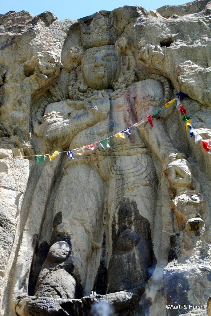
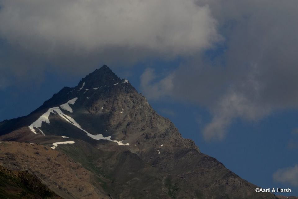
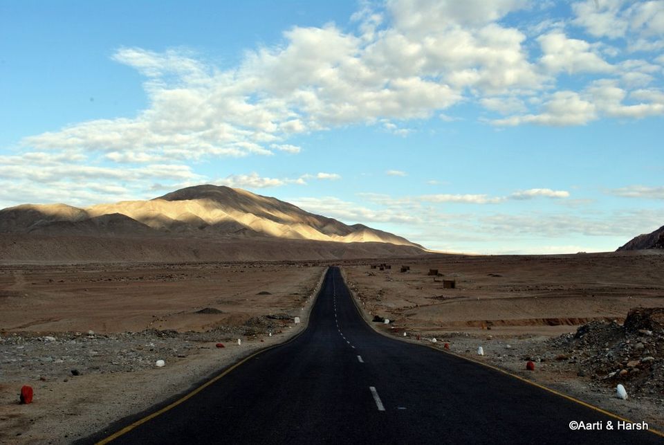
Day 9 (17th July): Kargil - Rangdum Gompa - Juldo (150 kms, 10 hrs)Finally day 9 dawned on us, the day we’d been waiting for since the beginning of the trip. Our plan for the day was to reach Rangdum and stay the night there. Rangdum to Kargil being only about 130 kms, we knew that there was no need to hurry. So we got up late and only left the hotel by 8:45 am or so. It was now time for Zannn-s-kaaaarrrrrr!!!!We left the town of Kargil, Suru flowing beautifully on our left, the valley becoming greener. The road was superb here, and we were gliding. We knew that the road was tarred only till Sankoo, some 40 kms away from Kargil, and so were enjoying the pleasure of driving on tar while it lasts. Our guidebook (which by the way is an excellent guide with intricate details of all places), mentioned of a rock carved statue of Buddha at Kartse Khar, a village near Sankoo. The detour for this village is bang in the middle of Sankoo - one crosses over the Suru river and proceeds east for about 7 odd kms, before coming to a well-marked cut for the statue. The 7m tall rock carved statue of Maitriya Buddha is pretty amazing. What is more amazing though is that it is situated in a primarily Muslim populated area. Even more surprising is the the fact that the statue is worshipped by visiting Buddhists almost on a daily basis. A little research told us that Buddhism came to Ladakh not from Tibet, but from Kashmir, in an era before Muslim prophets turned the local populace into Islam. This probably also explains the location of the statue.We were back on the highway by 11:30 am, the entire detour taking about an hour at the most. We then resumed our journey toward Rangdum, the Suru river faithfully accompanying us. In about an hour, we reached Purtikchey. Here the river expands to fill a relatively wider valley with an oustanding view of the Nun and Kun massiffs. We were able to see one of those peaks, the other sadly was shrouded in clouds. The meadows in Purtikchey would have made for an ideal lunch spot, but for us it was too early for a lunch break. Several locals, including some school children, had come all the way from Kargil for a picnic on the river banks. I would highly recommend people moving towards Zanskar to break a night here instead of doing it at Kargil. Just before Panikhar, we were told by the policeman deployed at the checkpost to cross over to the right bank of Suru. The road is a little better as compared to the one on the left bank. Since our breakfast had been very light, we ventured into the village to search for a dhaba but were unable to find one. We thought it might be better to break for lunch now at Parkachik. The road now starts to climb a bit, taking us quite high, leaving the Suru river below. The initial 10 odd kms of the climb is on an okay road, after which the tyre-ripping road to Padum begins. Jagged stones are strewn all over the road, and if one is not careful enough or unlucky, these stones have the potential to severely damage tyres. The greenery also reduces from here onwards, the landscape turning more barren. The road is devoid of any population after Panikhar, and one only finds a few small settlements scattered here and there till Padum. We reached Parkachik village around 2 pm, and by that time we were hungry enough to eat a horse, figuratively speaking. We had not anticipated the utter lack of dhabas on the route and were not able to find anything at Parkachik as well. The excitement to see the Gumri glacier just after Parkachik was building. And suddenly, after we turned on one of the many bends on the road, we saw it! The Gumri glacier in all its glory. What a sight! Our jaws were hanging open! This was the first time either of us was looking at a glacier so close to the road, and it was an overwhelming feeling! It was a sight to behold and a sight also difficult to describe in words. It was now getting difficult to ignore our growling stomachs, and so we decided to make our own lunch there, while soaking in the vistas around us. Out came our camping equipment - our little stove and cylinder - and Maggi packets with tomato puree which we’d bought from Sankoo, inspired by the tomato Maggi we’d eaten near Hamboting La. Cooking and eating next to the glacier was an awesome experience, and we thoroughly enjoyed those 45 minutes! Then, around 3 pm, we started again towards our destination for the day, Rangdum. Thereafter, one drives in the shadow of two of the highest peaks between Parkachik and Shafat. In fact, the Gumri glacier comes straight down from the ridge between the Nun and Kun peaks. However, the peak themselves are not visible from the road. Another lesser known peak, Pinnacle (6900 m), is clearly visible from the road, and just popped into our line of sight upon turning a bend. Standing at 3900 m and looking at a 6900 m peak right in front of us reminded me of the view of Shivling from Tapovan. While such views are common on treks, what made this memorable was that we were experiencing them from a MOTORABLE ROAD! After spending sometime beneath the peak, we moved ahead towards Shafat.

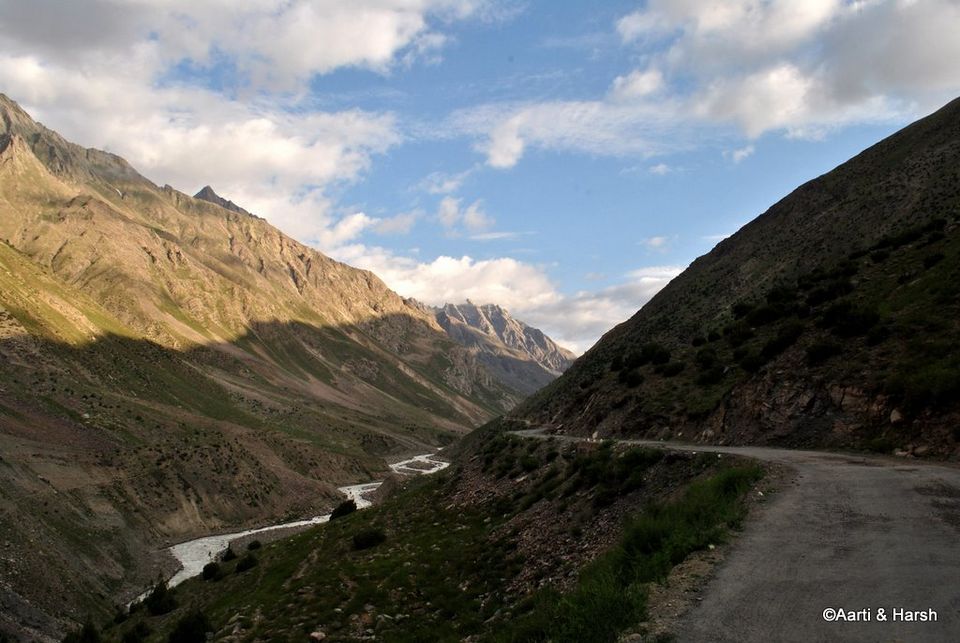
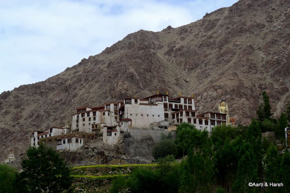
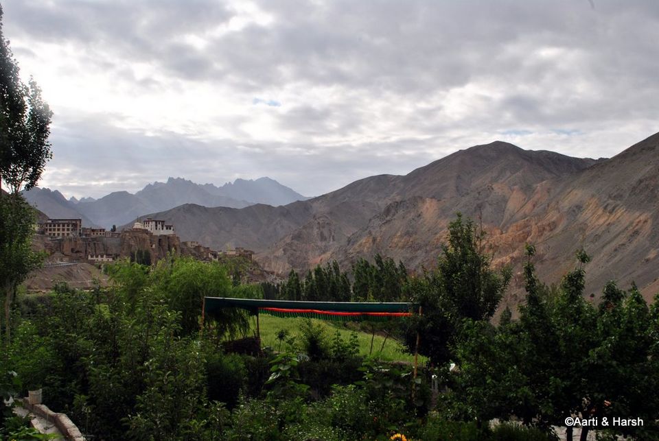
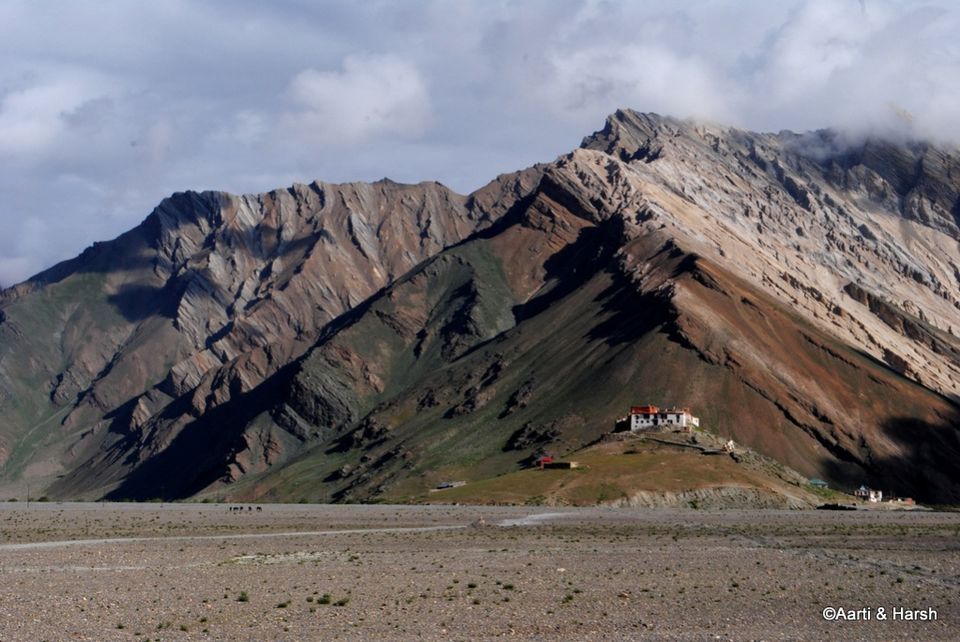
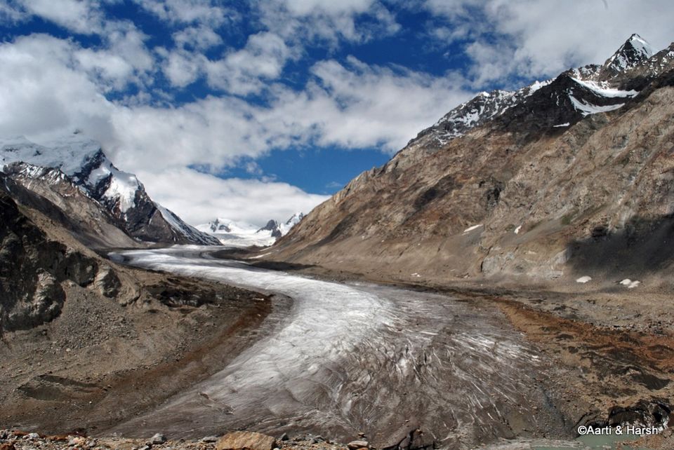
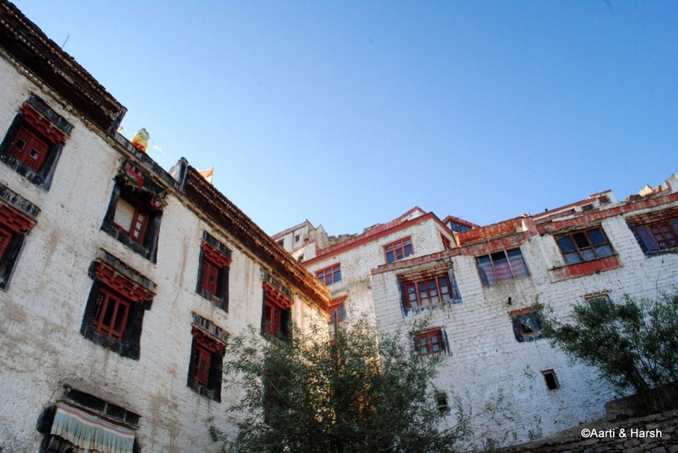
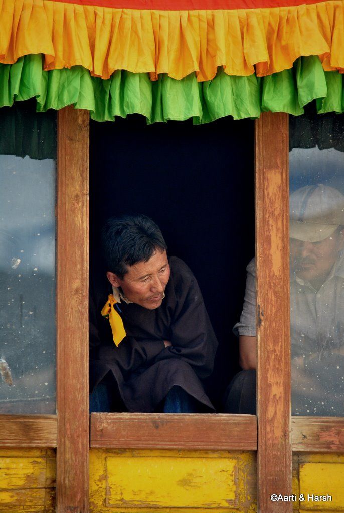
Day 10 (18th July): Juldo - Padum - Karsha Gompa - Padum (140 kms, 8 hrs)Having gone to bed at 10 the previous night, we woke up early, and promptly went to Tashi’s dhaba for breakfast as we’d promised. He was waiting for us, and quickly made some omelettes which we had with bread and cheese that we were carrying. After a photo shoot with him, we said our goodbyes, although only temporarily as we promised that we’d be back for lunch on our return journey. We would’ve been on our way pretty soon but Aarti’s love for sheep made me wait for another 15 min or so, while she spent some time with them. Moving on, we took the shortcut again through Suru’s basin and stopped for a moment to look at the memorial stone of the terrorist attack that happened a decade ago in the region. In the year 2000, terrorists had walked all the way from Kishtwar with the bakarwals (Kashmiri shepherds) and had entered the Zanskar valley at Shafat. They had then hijacked a lorry in which a German tourist was taking a lift, shot three monks of the Rangdum gompa who tried to help the German, and then eventually also killed the tourist before disappearing. Ever since then, the bakarwals are not welcome in the valley and there have been tensions between the two communities. After crossing the Tashi Tongtse village, we entered Marmot Country II, this time the population density being even higher! Pretty soon we began our ascent to Pensi La, which basically is a fraud! This would have to be the most gentle ascent of any pass situated close to 4000 m in India. We were at the top at about 9:30 and it had taken us hardly about 2 hours. In our excitement to see the views of the Drang Drung glacier, we had not taken too many pit-stops on the way. The pass itself is nothing exceptional, but the lakes around it make it quite scenic. Just before one reaches the top, one can see the source of the Suru river to the left. The view of the gigantic Drang Drung glacier appears just around a bend, and if one is not mentally prepared for it, it could come as a pleasant shock. The huge glacier appears all of a sudden out of nowhere, and the best part is that it is right next to the road. We’d been waiting with bated breath for the glacier, and now that it was in front of us, we were truly speechless. We’d known for quite a while that this glacier would be the high point of our trip, but to actually witness it right in front of us was an overwhelming feeling. The glacier starts from the mountains on the left of the road, and as it flows down, does a classic twist, which makes it all the more lovely. We parked our car on the side, and reveled in the scale of the sight before us for sometime. Both of us sat on a rock next to the road, silent, admiring nature at its best. Even the shutter remained silent. Finally, after about 20 minutes, we got up and began walking around, trying to get different views and angles to capture the massive glacier. After spending about half an hour doing this, we moved on, only to realize from another bend a few kms down the road that if we hiked a bit, we could we bang in front of the glacier, and would get even better shots. Our estimate said that the hike would not take more than 10 odd minutes, and so we set off. However, as is usually the case with these hikes, it took us much more than 10 minutes, but the hike was worth the view we got at the end. We could see the glacier in all its glory, from end to end, i.e, from its source to its snout. The classic twist of the glacier looked more pronounced from this view point. Thankfully, there were some clouds which made it possible for us to just sprawl over a rock and relax! With Padum hardly a couple of hours away, we had ample time to kill. Soon, the sun came out, and we decided it would be better for us to hit the road again. All in all, I think the glacier took a good two hours of our time. Satiated, we moved ahead, glad to know that we would see the colossal glacier again in a few days. The drive from Pensi La to Padum took us about 3 hours overall, and we reached there just in time for lunch. The road is in a pretty bad condition, more so because it has never been tarred. The drive is jittery, the road being level but full of pebbles, but it does not have potholes or slush, thus 4x4 is not a necessity. It is also devoid of settlements and it is only when one gets close to Padum that small settlements begin. For the longest time, one drives next to the Stod river, also called Doda by some. As we crossed the bridge at Tungri, the unthinkable happened - we saw tar! Aarti was convinced that the tarred road would not continue all the way till Padum, but it fortunately did! After driving for 1.5 days on stones, the smoothness of tar was very relaxing. n Padum, we immediately began our search for some decent accommodation for the next 3 days that we were going to spend there. Some huge trekking groups had converged on Padum from all directions, and all the decent hotels and guest houses were taken. The JKTDC was available at 200 bucks a day, although the state of affairs inside the room was quite horrible. Having no other option, we decided to stay there for a night, and then move to a better hotel by the name of Geyskit in the main market the next day. Although a tad expensive at 1200 bucks a day, it was much more comfortable. The restaurant was great as well. Lunch happened at the New Geyskit restaurant further up on the main market road, which is a must visit restaurant in Padum. It dishes out fantastic local cuisines, especially the Shabalay.With a bit of sunlight still left, we decided to head to Karsha Monastery, which offers some outstanding views of the Padum and Pishu villages. The road goes all the way up till the monastery now and from there one climbs a flight of steps to reach the top. I would highly recommend to make the monastery an evening trip as it offers a commanding view of the valley, which looks all the more divine in the dying light of the sun. We spent a lot of time there, just sitting in their central courtyard, relaxing. It was one of those rare peaceful evenings of our trip. Thereafter, we returned to Padum, and called it a day after having a delicious dinner at Geyskit restaurant.

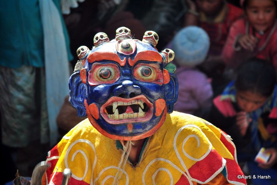
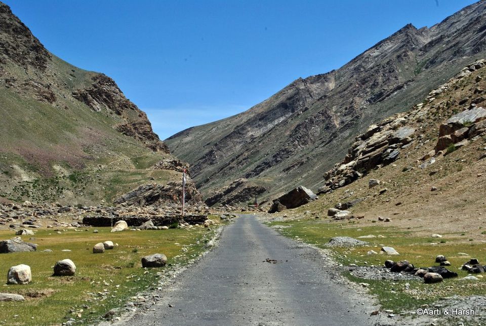
Day 11 (19th July): Around Padum - End of Road-Zangla and Stongde (130 kms, 7 hours)It was a very lazy beginning to the day and I was out to get some tea for the both of us when I met Col. Vohra. He was also staying at the JKTDC hotel in the room next to ours, and was traveling alone with the first leg of his journey being Zanskar. He further planned to cover a lot of areas in Changthang, and being from the Army, his Safari could go to regions where us mere mortals can only dream of going! Over tea, we exchanged stories, and finally parted after taking some shots of all of us together - the three of us and our two steeds, one black, the other white. It was a matter of real coincidence when we got to know that Col. Vohra camped right next to our friends’ tent at Chandratal two weeks later. The world is indeed small for like-minded travelers. The facilities at JKTDC were poor, to put it mildly. There was hardly any water in the bathroom, the rooms were quite dirty and there was also no provision for hot water because the kitchen was not working. After getting ready, we checked out from there and went straight to Geyskit hotel where we first checked in, and then sat down for a longish and tasty breakfast in their cosy restaurant. Finally, at about 11 am, we left the hotel to embark on our plan for the day. We got to know from the locals that Gustor, the annual festival of the Stongde Monastery, was going on. Gustor is typically celebrated in November end, by which time the entire Zanskar valley is disconnected by road. This year, however, they had decided to celebrate it during the ‘tourist’ season, as this would also lead to more money flowing into the local economy. One could call it commercialism, but I would prefer to call it smart thinking. We decided to first check out the end of the road beyond Zangla (yes, the journeys-to-the-ends-of-roads are back with a bang!), which was also on our agenda for the day. The road moves east out of Padum and is tarred almost all the way to Zangla, which is about 30 kms away. As one leaves Padum, the confluence of the Stod and the Tsarap Lingti rivers can be seen and the mighty Zanskar river is born.We crossed the Stongde village, which is about 10 kms from Padum, without stopping there. It took us about an hour to cross Zangla, and we moved on further, all the time driving next to the Zanskar river. The last village on the road is Zangla, after which all the villages lie on the opposite bank of the river, connected to the road with pedestrian bridges. The road beyond Zangla is also tarred, and remains that way till where the road ends. The valley before Zangla is VERY wide and really barren. However, beyond Hanumil, a village 25 kms from Zangla, the valley gradually narrows down, and becomes quite dark and more like a gorge. It probably stays this way all the way up till Chilling, where we’d described the valley in a similar fashion when we’d checked out the end of road beyond Chilling. The road extends a good 10km beyond Hanumil village.A few switchbacks later, we saw a landslide - a heap of stones on the road - and knew that this is where the road ended for Kiyang. We walked a bit up the road, but decided to take a U-turn about a km ahead. A few workers informed us that the road was complete till about 3 kms from there. We were back in the car by 1:30 pm.We headed back towards Zangla, and reached there in an hour flat. The climb towards the Zangla fort is pretty steep and it was the first time 4WD was engaged in Zanskar so far. The fort looked pretty much deserted, and we had forgotten to take the keys from the owners in the village below. We knew about the key part because of our know-it-all guidebook! When we reached the fort, we made a small discovery - the road extended beyond the fort as well! We thought of exploring it further, but hardly 500 m ahead the road came to an abrupt end while descending. It was a difficult spot to take a U-turn and after probably 10-15 odd tries, we managed to finally do it. According to our Leomann map, a trek went from there all the way to Sarchu. It was almost 3 pm by the time we reached the main road again and immediately started moving towards Stongde. The climb to Stongde is a little steep but manageable for a non 4WD. The sputtering of Kiyang’s engine returned with vengeance on the climb and it once again lost power. It was quite baffling for me since we had got the filters cleaned at Kargil, and the car had responded well to that. However, here on this climb things were again going downhill. We decided to try the climb nevertheless. A climb on which I would not even have engaged the 4WD mode, I had to actually turn to the 4L mode for more torque. I made a mental note to make calls to some experts back home (read Tanveer) to resolve this issue when we reached Padum.When we finally reached Stongde, the festival was about to end, and apparently the last ceremony was underway. We’d seen photographs of the Hemis festival, but it was great to actually see the Cham dancers perform live. We positioned ourselves on the roof of the monastery and started clicking away to glory. The sun was very harsh and we were sweating even in our light clothes, but the dancers seemed all happy and cheerful even in their heavy costumes! We witnessed the ceremony for about 20 minutes before it ended, and then made our way back to the car. In the outer veranda of the monastery, we stopped to have some bananas being sold by some local vendors, being hungry as hell. Around 5 pm, we finally left for Padum. As we reached Padum, I dropped Aarti to the hotel, and then referred to the guidebook to see possible causes of problems with Kiyang. On not coming to any conclusion, I made a call to Tanveer next, who thankfully took out a good 30 minutes to attend to my call during a working day. He diagnosed water in the sedimenter as the probable cause of the stalling of the engine. With detailed inputs on how to drain the water from the sedimenter from him, I went under the vehicle to get the job done. Afterwards, I took the car for a spin to test if things had improved, and they had considerably! Thanks buddy for helping me out, wonder what I would have done without your help. Once this was done, I realized how tired I was, and how badly I smelled of diesel. A quick shower was all I needed to get the stink off me, and get rid of some of the tiredness as well. Later, as we were sitting in the restaurant looking at the shots of the day and waiting for our pizza (Yes, pizza. Contrary to what one may think, they serve pretty good ones.), a guy came up to us to ask if we were working at the new dam site nearby. We, of course, responded in the negative, and he was pretty surprised to know that we were actually tourists. He explained that Indian tourists were quite uncommon in Zanskar, and it is primarily the foreigners who deem Zanskar fit to be on their itinerary. Hmmmm. The pizza was fantastic, and sleep came as soon as went hit the bed.

Day 12 (20th July): Around Padum - Dzonkhul, End of road beyond Reru (135 kms)We got up early with the plan to first go to Dzonkhul and then come back for breakfast. Although Dzonkhul is on the way to Rangdum, stopping there on our way back would not have been possible due to lack of time, also a trip to Dzonkhul and further on to Padum would have been too much to do for a day. We were on our way by 6:30 in the morning. At the Tungri bridge, instead of taking the road which crosses the Stod river and goes on to Rangdum, we went straight. The ‘road’ now was quite bumpy and was being leveled by the villagers. At Ating village, we gave a lift to an old man who was going to the Monastery with supplies of a puja scheduled for that day. We then took a left towards the Monastery, and started climbing. Now this climb was awful, the road scattered with rocks of all sizes, and we moved at not more than 15 kmph. I would imagine 2WD jeeps facing extreme difficulties maneuvering through this stretch after the village and would suggest stretch essentially for 4WD as it is loose gravel with terrible ascent and U-bends. Finally, after a very treacherous ascent, we reached the cave monastery of Dzonkhul. And what a sight it was! Built on a slope just below some jagged rocks, the Monastery peeks out of a cave, and the prayer flags adorning the monastery complex provide the much needed colour in the stark landscape. Village Dzonkhul must consist of less than five households, and most of them cater to the needs of the monastery. As we entered the monastery, a monk came to greet us, and then started showing us around. He first took us upstairs to a room the roof of which was the cave’s roof itself! It was very dark there with the little light coming from the burning lamps. The roof of the cave here was full of coins stuck to it, and looked like a dark sky with stars! We somehow managed to get one photograph since using flash was not allowed, and their was no way in heaven a tripod would’ve fit in that cramped room. After that we went to the terrace and then to a couple of other rooms which housed their ancient scriptures and books and other precious valuables such as cups studded with semi precious stones. They also had printing blocks of the scriptures and print new ones every now and then. Finally, the lama took us to a room where all the resident lamas of Dzonkhul were having their breakfast. They asked us to sit with them, gave us two bowls and filled them with the soup all of them were having. Now I know this will sound really mean, but that soup was AWFUL! I somehow finished mine, gulping down most of it so that it did not linger on my tongue, only to see Aarti looking expectantly at me to finish her portion too! I knew she wouldn’t have it, and that it did not look good not to accept their generous offering, so I had a second bowl too After thanking the lamas for the meal, we went downstairs and had chai with the people who were cooking lunch for the monks. They also gave us some bread, which was delicious! Over tea, we chatted a bit with them, and then bid adieu to Dzonkhul. The journey was quite tiring, and it was nearly 11 am by the time we reached Padum. After freshening up, we had an early lunch. The next thing to do was to check out Reru, which lies further south from Padum and the end-of-the-road beyond it. We left around 1 pm for Reru. We got lost at first. One has to go towards the older part of Padum, a Muslim dominated area, and take a left near the bus stand. The road runs parallel to the Tsarap Lingti, and the valley is pretty narrow. First up is the Bardan gonpa, perched precariously on top of huge stone which protrudes into the river. The road till Reru is tarred, although not very smooth, but after this the tar disappears completely. Here we saw a bunch of lamas playing cricket in a wide, open ground. About 6 kms from Reru, we came to a bridge to cross over to the right bank of the river. I believe this was the place where Salil went upto during his excursion to the region way back in September 2009. With the bridge now complete, we crossed over. The road from here on is very narrow and is a complete dirt track with a steep ascent to the village of Itchar. I wonder how would normal traffic cross this stretch given its sharp ascents, tight U-bends and narrow road. It was here when our car started acting up again, losing power on the incline! It was very frustrating, stretches which were supposed to be done in 4H mode were now being done in 4L mode and at extremely high RPM. There was an option to turn back towards Padum as the scenery was hardly beautiful or enticing, but being spoilt, we had to see the end of the road before we could turn back. We crawled ahead, occasionally having to deal with loss of power as well. The road was too dusty for me to crawl down and drain the sedimenter and decided that it would best be done on the way back. The road continued like this for about 8 odd kms from the bridge, before it came to an abrupt end where work was still being done. It was time for us to turn back. The drive back till Reru was again painful where I finally disembarked from the car and went down to drain the sedimenter. Once I was back on the wheel, the vehicle refused to start even after multiple cranks. Finally, I opened up the bonnet and primed the fuel pump a bit, and finally Kiyang started with a sputter. It was a smooth ride from that point till Padum which we finally reached by about dusk. This was the first detour that we regretted taking, the drive was neither beautiful nor worth taking, in our opinion. I would suggest further travelers to the region to avoid this drive until it’s complete all the way to Purne, which is about 15 km away from where the road ends currently. One could then trek to Phutgal gompa which I’ve heard is quite beautifully located, and the valley beyond Purne towards Kargyak and Darcha is very wide and spectacularly beautiful. Until then, it’s best to avoid the stretch. We had to start early the next day as we were targeting to reach Kargil in a single day from Padum, so hit the sack early.

Day 13 (21st July): Padum - Kargil (230 kms, 11 hrs)The day began very early at 5 am. It was the day we were supposed to bid adieu to Zanskar for sometime to come. We were on our way back with Kargil being the destination for the night. We left our hotel by 6 am, admiring the beauty of the barren landscape in the morning light. We were a bit stressed about the car’s condition, and thus wanted to reach Kargil as early as possible to see if something could be done to repair it. Although it was unlikely that any repair work would’ve been possible there, but still, as a wise man once said, “hope is a good thing, maybe the best of things”.Around 7:45, when we’d started feeling really hungry, we took Kiyang to the banks of the Suru, took out our little stove and heated the only ready-to-eat packet we had left - gajar ka halwa! It was pretty windy, and the stove had to be kept inside the car to keep it from getting extinguished. So, at 8 in the morning, on the banks of the Suru river, in the remote Zanskar region, the two of us, all packed up in sweaters and jackets, had a breakfast of piping hot gajar ka halwa! And as someone rightly said: “Gar firdaus, ruhe zamin ast, hamin asto, hamin asto, hamin asto”. (Loosely translated: If there’s paradise on earth, it’s here, it’s here, it’s here). Tasty breakfast at such a picture perfect spot... it felt as if things really could not get any better. Well they did - Aarti allowed me to smoke a cigarette without shouting too much . The descent to Rangdum was easy, and we were there by 11:30. We stopped at our friend Tashi’s dhaba for an early lunch, as we’d promised him we would three days ago. Then, after making another promise of sending Tashi his photograph, which, by the way, Rajiv Bharat (rkbharat) was very kind to have hand-delivered on his trip there in September, we hit the road again.On we went, our bodies now used to the constant rattling of the car on the un-tarred road, happy that we would make it to Kargil by 4 if we maintained our current speed. And then, jwhen were were about an hpur away from Parkachik, it happened again. Kiyang sputtered, and we looked at each other, not knowing what to do now. The only thing that could be done was to drain the sedimenter, and so I got out out the car and readied myself to perform the now familiar drill of lying down on a mat near Kiyang’s exhaust and unscrewing the sedimenter to drain the water that had accumulated in it. Only this time, in my frustration maybe, I screwed back the sensor with a little more strength than required, and it came off! The bloody design is so flawed, I mean who in their right mind would make a plastic screw of a metallic component? That’s cost cutting my dear friends, and that’s how Tata Safari is cheaper than let’s say a Toyota Fortuner (of course, there are many other factors as well and not just a plastic screw ). So there we were, stranded at 3500 m above sea level, beneath a glacier with diesel leaking through the sedimenter, and the only thing stopping the leak was my finger which was shoved up the sedimenter. And I, of course, was lying on my back on the ground. I stayed there for about 10 minutes, panicking and kicking myself for not carrying M-Seal or some adhesive that would’ve got me out of such a sticky situation. In this remote part of the world, help could be another hour or two hours away. I was resigning myself to be in the uncomfortable position when I heard the roar of a taxi. Aarti tried to flag it down, but the guy did not stop! Now let me take a break here to explain, as I perceive, the difference between people on the Manali - Leh highway and those on the Leh - Srinagar highway (or in this case Padum - Kargil highway). Had this been the Manali - Leh highway, the taxi would’ve stopped without Aarti even having to flag it down and would’ve asked if he could help. However, on any other highway, people just pass through and don't even stop! Such is the difference between camaraderie on different highways in India. The first objective was, of course, to stop the leaking fuel. After a few minutes of panic, my brain started working again, and I remembered that the oil filter had a pretty similar screw to the one that had come off, minus the sensor for the sedimenter. Fortunately, I had kept an extra oil filter, and was thrilled to see that the part did actually fit. With the fuel leak stopped, I cranked up the car again to see to my horror that the sedimenter light went on! The sensor connecting the sedimenter to the engine ECU was dangling in mid-air. This led to a high RPM and the manual suggested the driver not to drive the car for a long period in such situations. I knew that there was no water there now, but it was only the sensor acting up. Upon closer inspection of the sensor it became clear that the two strobes were connected by a drop of liquid which was conducting the required electric signal to fire the ECU sedimenter warning up. I wiped the strobes dry with a piece of cloth and then bandaged it well with non-conducting tape (electric one). By doing that the signal for the sedimenter immediately went off and the RPM was returned to a normal engine beat. So after about an hour of struggle we were good to resume our journey.Another hour later as we were crossing the Gumri glacier close to Parkachik, it happened again. The sedimenter warning went up and the RPM went wild again. I went down, again, to check on the strobes, due to a water splash the strobe was wet again and was conducting. The tape was unwound, the strobes wiped dry, a plastic was tied to the strobe so that further water splashing does not effect the strobes and we marched on. And of course, since I was down there, I drained the sedimenter again!At Sankoo, 40 kms before Kargil, we managed to locate the road that goes directly to Dras through Umba La. This road branches off from the main market in Sankoo. Had Kiyang not been unwell, we would definitely have taken this road and then stayed the night in Dras. Well, some other time I say. We managed to reach Kargil, despite all these delays, by 6 pm. The casualty of all this was of course, the peace of mind and photography. It’s difficult to shoot under such trying circumstances. Aarti checked into D’Zojila, and I again went around to what seemed all the mechanics in Kargil to see if they could fix the sedimenter. But Safari spare parts are hard to come by in a small town like Kargil, and after several futile attempts, I returned to the hotel around 7.30. After a quick bath, we went into the market for a dinner of Kashmiri food.

Day 14 (22nd July): Kargil - Srinagar (230 kms, 10 hrs)Day 14 was a race against time. We had to reach the Tata service station in Srinagar by 4 pm at the latest to give them enough time to repair Kiyang. Being a Friday, we knew we were in a tight spot. If the car could not be repaired today, we would be stuck in Srinagar till Tuesday, for the next 3 days. So yet again we got up early and were on our way by 6:15 in the morning. The first photo op was the Harka Bahadur Memorial, at the point which is probably the closest that the Srinagar-Leh highway gets to the LoC. Here, the mountain across the river IS the LoC. The Suru river meets the Dras river here to form the Shingo river which then flows into Pakistan.We moved on, and were, for a while, accompanied by laden apricot tress on both sides of the road. As we approached Dras, we came across the relic of the five Buddhas, which we’d missed the last time. About 5 kms before Dras, a signboard told us that to the left was some mythical stone which sounded pretty interesting. We decided to take the detour, but were unlucky. We did not find the relic, and to be frank did not try very hard to find it either. The detour re-joined the main road, but by then we’d surpassed the War Memorial.We thought of going back, because we wanted to stop and pay our respect, but given that we were pressed for time, we decided to move on. At Dras, we stopped for a quick breakfast in a dhaba which had a direct view of the Tiger Hill. Dras definitely gives rise to intense feelings of patriotism. Immediately after Dras, we found the Dras - Umba La - Sankoo road, and were again tempted to try it, but sadly we could not. As we moved on, we kept coming across memorials and stones dedicated to the soldiers who’d lost their lives in Operation Vijay and other operations over the years. Thereafter, the climb to Zojila began. Just before the actual climb begins, there is a Sonamarg like meadow on the left known as Minimarg where one can always find a few horses grazing. The ascent to the pass wasn’t all that bad, and it took us about 40 minutes. Kiyang acted up again for a while during the climb, the first since morning but I was too tired of draining the sedimenter and now with no immediate climbs foreseen decide to give the activity of draining the sedimenter a miss. The Zojila War Memorial again reminded us of the amazing feat of the Indian Army who’s driven a TANK to the pass way back in 1948. Deep respect. The road on the descent was good, and we soon caught a glimpse of the Amarnath madness below. The valley seemed to be made of tents of all colours, and instead of birds, we could see helicopters flying everywhere. If this was the situation in Baltal, we feared for Pahalgam, which is the main starting point of the yatra. Halfway through the descent, we were stopped due to some work on the road being done. We spent a good 1-2 hours there, constantly worried that we would get late to reach the service station. At 1 pm, we were finally allowed to move on, and we rushed. The Sonamarg valley is very beautiful but the smell of horse shit there is so overwhelming that we dared not open the windows of our car. We were hungry, but Sonamarg was swarming with people, and we just could not bring ourselves to stop there for lunch. On the way, we also came across the proposed staring point of the Zojila tunnel, and were quite excited at the prospect of another tunnel! Now that Rahul Gandhi says that its construction should be given top priority, it should be complete in another 6 - 7 years. The entire road from Sonamarg to Srinagar was full of signboards welcoming the Amarnath pilgrims, and there was a crowd everywhere. So we did not stop for lunch, and just had some chips to wave over our hunger pangs. The road was good, and we cruised all the way.At 4, we reached the Tata service station. The service manager immediately refused that he would not be able to help us at all citing his resource constraints. The next day the workshop was closed due to a planned Bandh call in Srinagar. Sunday the workshops were officially closed and he mentioned that he would be able to help us only by Monday. It was only after explaining our situation to him and that waiting till Monday was not an option for us, he relented to have a look. Immediately after listening to all the problems going on for the past week, he came to the conclusion that the fuel quality can be the only issue. He did mention that in the past month a lot of cars were facing this issue in the region, specially on the Srinagar - Leh circuit. He mentioned that as soon as we switch to good quality fuel the problem should go away. However, we did have a problem of a broken sedimenter sensor. The only solution to that was to change the sedimenter, since he did not have a spare sensor with him. The bloody thing costs about 4500 bucks, but we did not have an option. The change was not due for another 20,000km but we went for it nevertheless, buying a new sedimenter, taking out the sensor, installing it and keeping the new sedimenter intact with the spares, so that the “new’ sedimenter could be used at it’s scheduled change. So all in all the cash-flow was affected, but at least it was not an “expenditure”. With the new sedimenter and a trial run in which the manager himself took the car out for a spin and touched 140kmph, I was satisified that the issue has been dealt with once and for all. At about 6:30 pm we headed towards main Srinagar to retire for the evening. Once in Srinagar, we spent some time looking for a hotel, and finally checked into Hotel Zamrud on the Boulevard. For dinner, we chose to go to Ahdoo’s, one of Srinagar’s oldest restaurants, and also our favourite there. The plan for the next day was to rest at Srinagar before giving a final push towards Delhi. We decided that Wular & Gulmarg should be worth our while to visit.

Day 15: Around Srinagar - Wular lake & GulmargThe day began in anticipation. The plan was to circumnavigate the much heard of Wular lake. For the uninitiated,Wular lake is India's largest fresh water lake is located in Bandipore district. It is also one of the largest freshwater lakes in Asia. The only concern was the strike that was happening int the districts around Srinagar due to some clash with the government and the army with the locals. Still we marched ahead. The drive would be marked as one of the most disappointing drives of my life. With a high level of expectation set for Wular, what we saw was pathetic to be blatant. The entire lake was dry, despite being the month of July and was hardly visible from points along the road. The route was dotted by villages after villages which wore a deserted look due to the Bandh. There were certain points on the drive on which the lake was visible, but the view was highly disappointing. The entire lake was covered in weed, and was hardly visible. I had to convince Aarti that we were actually seeing the lake. A long 3-4 hours ride later we were finally back on the highway, heading back towards Srinagar. The day had been disappointing so far, and to make it worse further we saw the board towards Gulmarg and decided to head towards it. The drive towards Gulmarg is now a great highway which is 2 lanes on either side. The average speed was nice and the climb towards Gulmarg was also quite beautiful. However the destination itself was quite pathetic. The entire parking was swarming with tourists who were treating the whole place as their personal garbage bin. Throwing items left and right. We were also bugged by ghodi-waalahs who wanted us desperately to go around the meadow in their horses. Not to metion that the entire place smelled of horse-shit. Disappointed again we decided to just have lunch at Gulmarg as quickly as possible and head straight towards Srinagar. Back in Srinagar by evening and had a decent evening alongside Dal lake. A shikara ride was call of the hour along with some kebabs being sold next to the lake (which were very pricey by the way). With the trip now almost over, the next two days would be spent on the highway back towards Delhi and a “normal” life. The magical two weeks had gone by, only to be revisited hopefully in 2012.

Day 16 & 17: The long drive back to DelhiThe flipside of coming back from Leh via the Sringar route is the LONG drive back home. The drive becomes more or less uninteresting the moment one leaves Srinagar valley. To keep it interesting we took out the "Highway on my plate" - guide book and made it a point to visit the Dhabas enroute. An early start from Srinagar saw us having breakfast on the other side of Jawahar tunnel amidst torrential rain. The breakfast was heavenly of Warqi Parantha with freshly made Atta ka halwa in a tiny shackle of a dhaba on the roadside. We had to keep the breakfast light keeping in mind the next eating stop of Rajmash Chawal at Peera Morh. The next stop was to pick up Son halwa at a village just after Patnitop. However we just had enough space to taste eat. The rest was left to be eaten later on. The gastronomical ride took a rest, and it was some dreary driving all the way to Pathankot. We thought of picking up "Palangtod" there but at the last moment decided against it. The night was spent at a lavish 4 star hotel, i forget the name now, in the middle of Jalandhar. They were desperate to have us there, and the tariff was reduced from 6k to about 1.5k if i remember correctly now. Being a nice hotel, and delhi not being far away. We started off lazily on the final day of the drive. A dhaba between Jalandhar & Ludhiana was to become our breakfast point, although not that great. And again i forget the name of the dhaba. We had to give Puran singh ka dhaba (at Ambala) a miss, as we were pretty much stuffed with food by now. The drive toward Delhi was uneventful, but as always such drives leads to very interesting conversation. This time the conversation led to another trip planning towards Ladakh, but this time on a bike. Action has already begun on the planning and purchasing part of the next trip, which led us to buy a new tourer in the family, WanderB. A Classic 500cc...


' fill='%23359391'%3e %3cpath d='M46.1538462%2c43.5714286 L41.5%2c50 L36.8461538%2c43.5714286 L36.8670256%2c43.5714286 C36.3173077%2c42.7142857 36%2c41.6851429 36%2c40.5714286 C36%2c37.4854286 38.4535641%2c35 41.5%2c35 C44.5464359%2c35 47%2c37.4854286 47%2c40.5714286 C47%2c41.6851429 46.6826923%2c42.7142857 46.1329744%2c43.5714286 L46.1538462%2c43.5714286 Z M41.4294872%2c39 C40.6150641%2c39 39.9487179%2c39.675 39.9487179%2c40.5 C39.9487179%2c41.325 40.6150641%2c42 41.4294872%2c42 C42.2439103%2c42 42.9102564%2c41.325 42.9102564%2c40.5 C42.9102564%2c39.675 42.2439103%2c39 41.4294872%2c39 L41.4294872%2c39 Z' id='Location-white'%3e%3c/path%3e %3c/g%3e %3c/svg%3e)