
I was a lot excited towards my travel to the most wettest place on Earth - Cherrapunjee (of course Mawsynram holds this spot right now). Since I was on a very tight budget I had to plan everything beforehand since North East was a tricky customer to handle. With Google helping with everything, you don't need to worry much if you are a solo traveler.
My solo trip began from Guwahati. I got a bus to Shillong at around 8 am and it took 3 hours to reach there. On the way you could see the beautiful green mountains and the stunning Umiam Lake.

From Shillong I took a share taxi to Cherrapunjee popularly known as Sohra among the locals. The journey was a really picturesque one. The green landscapes, the pine trees and the water bodies were a treat to watch. One will also pass though the mighty Mawkdok Dympep Valley from where you will get a clear view of the Bangladesh Plains. I reached Cherrapunjee by around 12:30 pm.


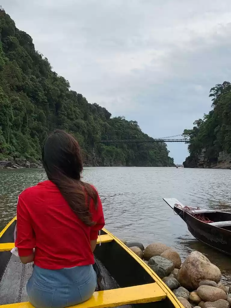
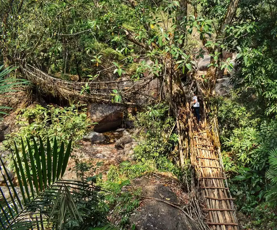
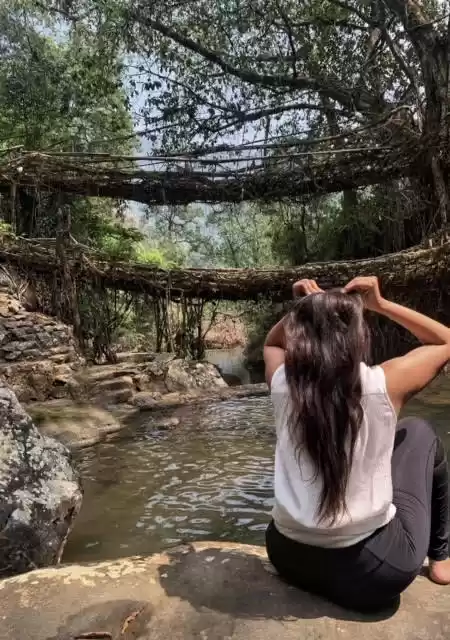
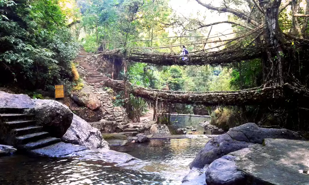
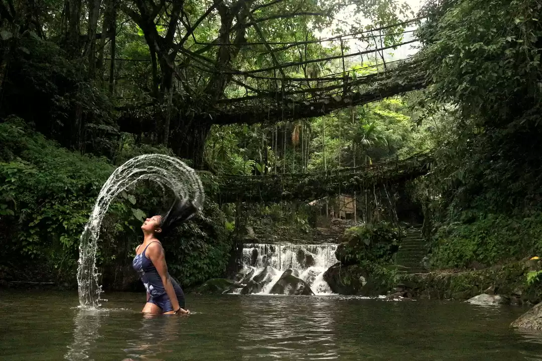
My first destination was the famous Double Decker Living Root Bridge in Nongriat village. These bridges are made by the Khasi tribes of Meghalaya by redirecting the aerial roots of trees using sticks and various materials. Living Root Bridges
I had to reach a village called Tyrna from where I need to trek down to reach Nongriat. Being a Sunday, share taxis where scarce on the road. I was lucky enough to get one but I had to sit on top of the taxi as it was completely filled. I always wanted to take a journey sitting on top of a bus through the Himalayan roads so this was a dream come true for me. The 12 km journey was amazing. It feels like you are traveling just beneath the clouds. The cold winds blowing to your face and the waterfalls on the way made the journey very special for me. The Bangladesh Plains were clearly visible. It feels like the dark green mountains suddenly stops and the plains starts.

I got down near Tyrna and now the trek starts. It is an easy trek with cemented steps guiding you to Nongriat. When I started the trek by around 3 pm, most of the fellow travelers were trekking back to Tyrna as it gets dark very early in these parts of the world.


It took me an hour to reach the Double Decker Bridge. There is a small pool nearby where a few people where having fun.

I checked in to Nongriat Guest House (its just the name; it has 4 double rooms and a kitchen) just nearby (₹200 per night). After resting a bit and having a cup of coffee, I started waking towards Rainbow Falls which is an hour from Nongriat. I walked past more bridges and reached a natural pool created by a small waterfall. Since it was going to get dark soon, I decided to have a dip there. I was the only guy over there. A dip far away from all the hustles of the world in the wilderness...I had never even dreamt of this. The waters sprinkling to your face from the top...reminded me of the Shawshank Redemption scene where Andy Dufresne escapes to the rain.
I went back to the Double Decker. The water was too cold now and it was getting very dark.I went back to room and spent my night there.
The next day I woke up early as I had planned a trek uphill to Nohkalikai Falls. I started from Nongriat at 6:30 am. This is a trek that only a few people takes and hence the path was not properly maintained.

There was a slight drizzle throughout the trek. For the first one hour the trek is not that difficult and I crossed 2 tiny waterfalls. Then the path gets more steeper and narrower. One has to do Monkey walking at various points as rocks are very steep. I saw around a dozen waterfalls on my way ( on the other side of the slope; some small and many big). Finally after 3 long hours I reached the top of the hill. I didn't saw a single person during this period.

As I reached the top the rain intensified a bit. The winds were too strong that even my shoulder bag which I had placed upon a rock was shaking. The long grasses were dancing with the wind. I could see about 3 waterfalls from this point.I started walking towards the Nohkalikai Viewpoint along the big grasses amidst the rains with "Castle on the Hill" playing on my phone (believe me the feel was great).
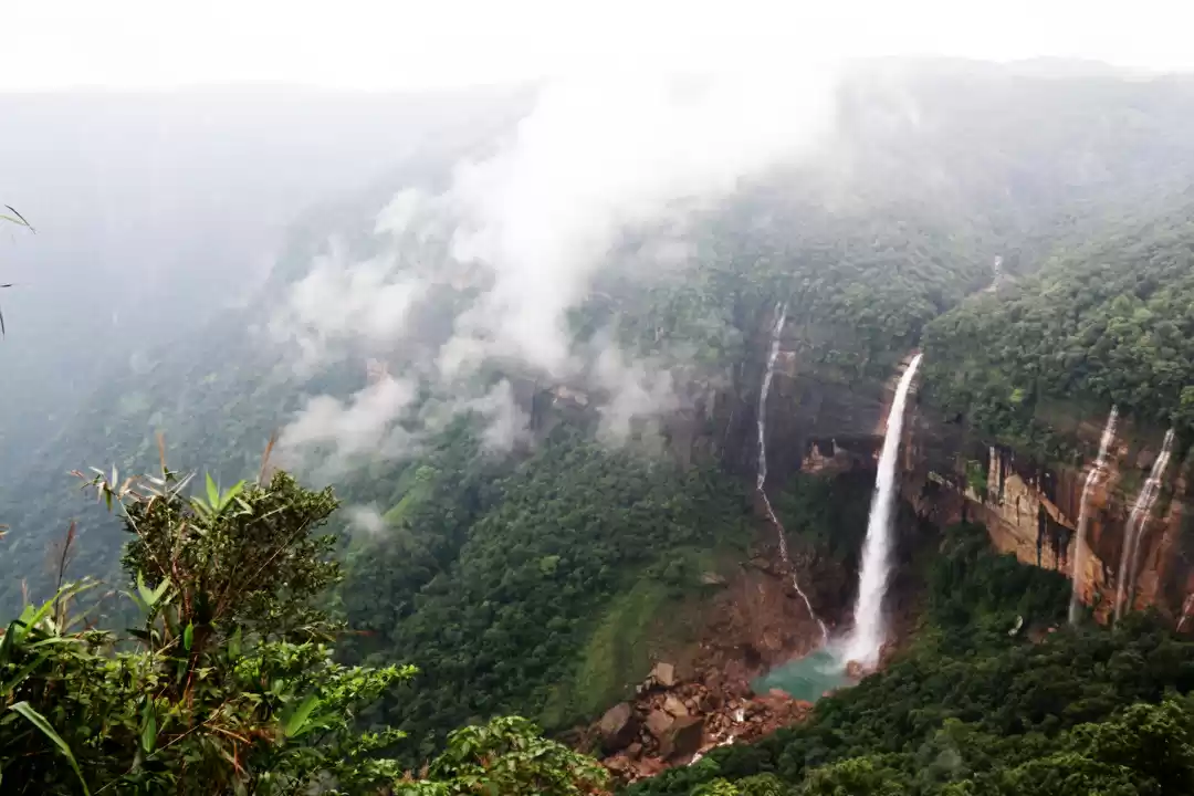
Nohkalikai Falls is the largest plunge waterfall in India with a height of 340 m. Since it was monsoon time, the waterfall was in its full fury. One is allowed to go to the bottom of the waterfall only during summers.

Now the rains were very intense and the main road is 5 km from here. Since I didn't had a taxi or cab I decided to walk the distance through the rain. I had an umbrella but it was of no use as the winds were very strong. One could hear the howling sounds of wind on the way. I wanted to take pictures of the route but I was not even able to unlock my phone pattern as both my hands and mobile screen were completely wet.
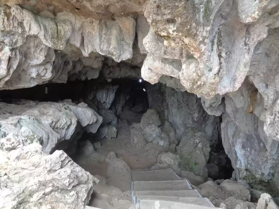
I reached Sohra Market and from there I took a taxi till Mawsmai Cave (approx 8 kms). It is a 150 m long natural limestone cave where natural formations like Stalactites and Stalagmites can be found. The cave is very narrow and is properly lit up for the convenience of tourists.

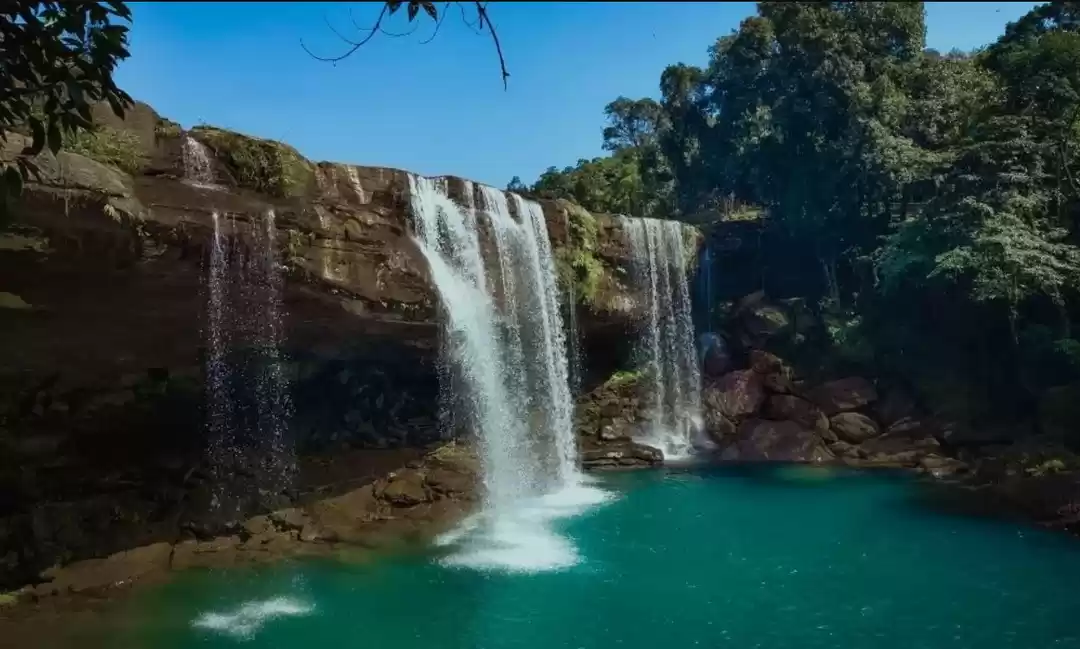
The Seven Sister Falls (or Nohsngithiang Falls) is just nearby the cave and is a beauty to watch. The falls got its name as it falls down as 7 segments from a height of 315 m. The rain was very intense and strong winds blowing from the deep gorges made matter more worse. When you are standing near the railing, the winds that blow up from the gorge made the raindrops falling on the grasses near the railing to recoil and to blow on to your face. Its like you are driving a motorbike at 80 km/hr though persistent rains. It was definitely a special experience. There were clouds all around so I didn't got a clear picture. The Bangladesh Plains were also visible.

I was 100% socked up and was shivering with cold. I had a hot cup of tea and it helped me to ease a bit. It was time to leave as I needed to return Guwahati by today night. I got a shared taxi to Shillong and this time the journey was different. There were clouds and mist on either sides of the roads and it felt like I was travelling through the clouds. The valleys were not at all visible this time. I was lucky enough that I got to experience the two contrasting weathers of Cherrapunjee.
PS: I only had my 5 MP mobile camera to click the pictures. Imagine how it would be like to see through your naked eyes!!!


' fill='%23359391'%3e %3cpath d='M46.1538462%2c43.5714286 L41.5%2c50 L36.8461538%2c43.5714286 L36.8670256%2c43.5714286 C36.3173077%2c42.7142857 36%2c41.6851429 36%2c40.5714286 C36%2c37.4854286 38.4535641%2c35 41.5%2c35 C44.5464359%2c35 47%2c37.4854286 47%2c40.5714286 C47%2c41.6851429 46.6826923%2c42.7142857 46.1329744%2c43.5714286 L46.1538462%2c43.5714286 Z M41.4294872%2c39 C40.6150641%2c39 39.9487179%2c39.675 39.9487179%2c40.5 C39.9487179%2c41.325 40.6150641%2c42 41.4294872%2c42 C42.2439103%2c42 42.9102564%2c41.325 42.9102564%2c40.5 C42.9102564%2c39.675 42.2439103%2c39 41.4294872%2c39 L41.4294872%2c39 Z' id='Location-white'%3e%3c/path%3e %3c/g%3e %3c/svg%3e)