


National Parks were designated in order to protect beautiful areas for the nation.
This blog was first published here.
National Parks were designated in order to protect beautiful areas for the nation. Northumberland National Park is situated to the west of the county of Northumberland, sandwiched between Scotland to the North, the North Sea to the east, Hadrian’s Wall to the South and Cumbria to the West, there are around 405 square miles of superb wilderness within the National Park to explore.The most northerly of the National Parks in England, Northumberland National Park is also the least visited and the least populated, although that is due more to its location than to any lack of interesting reasons for visiting. The southern border of the park is marked by Hadrian’s Wall, and some of the finest Roman sites in Britain lie within the park’s borders.This “land of the far horizons” is a scenic gem at the top of England, anchored by the Cheviot Hills and undulating southward in swaths of open moorland and grasslands, dotted with traditional villages and cut by picturesque valleys.Northumberland is justly famed for the ancient engineering marvel of Hadrian’s Wall. The wall was constructed in the A.D. 120s to mark the frontier of the Roman Empire and separate its lands from those of the barbarians beyond. Many centuries later, most of the turf-and-stone structure still stands, stretching across the landscape of Northumberland for 73 miles (117 kilometers). It can be walked end-to-end along the Hadrian’s Wall Trail. Continuing archaeological work periodically reveals new glimpses of life in Roman Britain; some of these are on display at the Roman Army Museum in Greenhead. The Romans weren’t Northumberland’s original inhabitants. People have lived here for at least 10,000 years, since hunters roamed the landscape in the days after the end of the last ice age. Permanent villages sprang up after about 2000 B.C., and during the Iron Age, after about 300 B.C., dozens of spectacular stone and earth hill forts appeared. Today they are among the finest in all of Britain.

Pembrokeshire Coast is one of three National Parks in Wales, the other two being Brecon Beacons and Snowdonia. It is the UK’s only truly coastal National Park. For centuries the Park has been a living, working landscape where people and nature co-exist. Its spectacular patchwork of rugged cliffs, sandy beaches, wooded estuaries and wild inland hills makes it a place of sanctuary for wildlife. In 1952, this wonderful place became a national park – the first park in the UK to consist entirely of wild, maritime landscapes. Plans for a Pembrokeshire Coast Path were underway within a year and the path, a National Trail, formally opened in 1970. It’s been a tremendous success, proving that conservationists, walkers and landowners can get along peacefully and paving the way for even bigger and better things. The coast path has always been special, but now that it’s part of the 870-mile Wales Coast Path, it’s better than ever. Walks can be long or short, linear or circular, steep or flat, and may lead you across gleaming sands or over clifftops with views to make the heart skip. Pembrokeshire Coast also includes a scattering of offshore islands many of which, like Skomer and Skokholm Islands, were named by the Vikings who cruised this coast between the eighth and tenth centuries. Though people lived on most of these islands since prehistoric times and farmed them into the 20th century only Caldey Island is inhabited today. While water dominates the park landscape Pembrokeshire Coast is also a spectacular place for walkers to stretch their legs along dozens of Wales’ best beaches, headlands, bays, cliffs, and scenic seaside towns. The park has 621 miles (1,000 kilometers) of trails, including one-hour strolls and 186 miles (299 kilometers) of the Pembrokeshire Coast National Trail. Year-round Coastal Bus Services, designed for walkers, cover the entire route so that strollers can set their own itineraries. Summer is the busiest season on the coast, when fair weather is best for beaches and boating and the frequency of everything from festivities to transport options is a bit greater. But each season offers its own rewards and something is on in the area year-round.

The history of Gran Paradiso National Park is linked to the protection of the ibex. In 1856 King Vittorio Emanuele II declared these mountains a royal hunting reserve, thus saving the ibex from extinction. Its population in those days had been reduced to an alarmingly low level. The king set up a corps of specialized guards and ordered the paths and mule-tracks to be laid down, which today are still the best network path system for the protection of the fauna by the modern rangers and form the nucleus of the nature trails for tourist excursions. Gran Paradiso National Park was the first of its kind in Italy and remains one of the best known. Filled with majestic mountains and valleys, as well as a variety of vegetation and animal life, the park in the Graian Alps is certainly something to experience. The park’s lowest valley is at 800 meters above sea level while its highest peak, which belongs to Gran Paradiso Mountain, is over 4,000 meters high. If you take a trip to Gran Paradiso you will experience gorgeous alpine grasslands, glaciers and unique rock formations that won’t soon be forgotten. Gran Paradiso National Park was the first of its kind in Italy and remains one of the best known. Filled with majestic mountains and valleys, as well as a variety of vegetation and animal life, the park in the Graian Alps is certainly something to experience. The park’s lowest valley is at 800 meters above sea level while its highest peak, which belongs to Gran Paradiso Mountain, is over 4,000 meters high. If you take a trip to Gran Paradiso you will experience gorgeous alpine grasslands, glaciers and unique rock formations that won’t soon be forgotten.

In 1938, Olympus, the highest Greek mountain, the residence of the twelve ancient gods, was the first area which was declared as a National Park. About 50 years ago a special regime was enforced to protect this unique part of our country. The aim was the preservation of the natural environment; of the flora, fauna and natural landscapes, as well as of its cultural and other values. Scientific research had to be supported and people had to become aware of the environmental conditions. Furthermore tourism had to be developed in the wider area. Specific laws prohibit any kind of exploitation in the east side of the mountain, about 10,000 acres, which constitutes the core of the National Park. The wider area around it was designated as “peripheral zone of the National Park” so that its management and exploitation won’t affect negatively the protection of the core. The mountain’s highest peak, Mytikas, tops out at 9,573 feet (2,918 meters). The ancients called Mytikas “Pantheon” and believed it was the meeting place of the deities. The 12 gods were believed to have lived in the alpine ravines, which Homer described as the mountain’s “mysterious folds.”The village of Dion, on the mountain’s flanks, was a Macedonian holy city where King Archelaus (414-399 B.C.) held nine days of games to honor Zeus. Today Dion houses a remarkable archaeological site, where work is ongoing, and an archaeological museum in which much of the region’s rich Classical history is on display. In the summer the Olympus Festival includes performances at the ancient theater. Olympus is a Mediterranean mountain; summers are typically warm and dry and winters are wet. High elevations are typically covered in snow for a full seven months (November to May). During any season the climate is apt to change as one climbs—for each 100 meters of ascent the average temperature typically drops by half a degree Celsius.
Norway has 44 national parks, 37 on the mainland and seven on Svalbard. From underwater wonders to high mountainous areas, these parks offer a variety of landscapes and a wide range of exciting outdoors experiences.Svalbard is Arctic wilderness and polar bear country. The opportunity to see one of these giants draws many visitors. But polar bears can be dangerous, and close encounters may prove fatal for the bears and, occasionally, for humans. People traveling in bear country are advised to carry flares or other deterrents to scare off aggressive bears—and high-powered rifles in case such measures fail.Nordvest-Spitsbergen National Park is a glorious land of mountain peaks, glaciers, and offshore islands. It is also home to Svalbard’s main historical monuments. Whaling stations and burial grounds were established here as early as the 1600s. The ill-fated balloonist Salomon Andrée took off from Virgohamn for the North Pole in July 1897. His remains, and those of his companions, weren’t found until 1930. Visiting the remnants of his camp, and other sites on Virgohamn, requires a permit from the governor.As its Arctic Ocean location would suggest, Svalbard is a land of long, cold winters with extended periods of temperatures from -4 to -22ºF (-20 to -30ºC)—not including wind chill. Between December and May visitors can explore the islands by skis, snowmobiles, or dog sleds. Boating is possible from early June until mid-September.

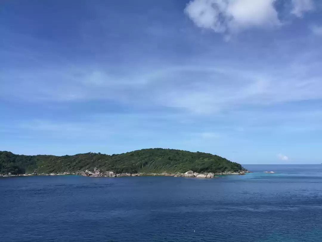
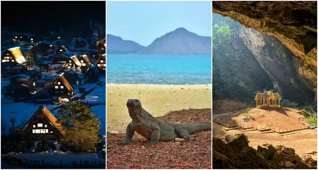
Established as a national park in 1982, Similan Islands are an archipelago of 11 islands in Phang Nga Province 70km off the coast at Andaman Sea, covering an area of 70sqkm. With a rich marine life consisting of magical hard/soft coral reefs, crystal clear waters and white beaches it is concidered to be one of the best diving sites in the world.”Similan Islands” is an underwater paradise teeming with life at large. The coral And among fishes. The water was crystal clear glass and has a beautiful white sand beaches. Similan is famous for its beautiful deep water, 1 in 10 of the world’s top sailing and rock as a symbol of the Similan Islands National Park. Leasing is located at the island, 8 (Similan Islands) that is very beautiful. And is a highlight of the Similan Islands. Consists of numerous islands with high and steep granite mountain, beaches and rocks formation of many shapes. The shoreline of each islands are of inconsistent curves since they are situated in the outer part of the sea and are worn away directly by waves. Part of the water lies in the Andaman Sea and eastern side of the Indian Ocean while the shoulder of the continent borders the western shoreline of Phang Nga province and Union of Myanmar, paralleling the Nikobar Islands of India. There is no mud at all along the beaches, so the sands are very clean, white and very fine. Some islands do have hills in the area, which are usually quite tall with the highest top of 244 meters above mean sea level, while some islands are of flat area surrounded by sand dunes and coral reefs.Summer begins in mid February and ends in May. Rainy season starts from mid May till October with North – Western wind. Average annual temperature is 27๐c with average of approximately 83% humidity all year round. Average annual rainfall is measured at 3,560 millimeters with evaporation rate of 1,708 millimeters per year. In rainy season, the national park will be closed during 16 May – 31 October every year for visitors safety.

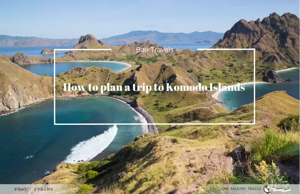
Komodo National Park is located in the center of the Indonesian archipelago, between the islands of Sumbawa and Flores. Established in 1980, initially the main purpose of the Park was to conserve the unique Komodo dragon (Varanus komodoensis) and its habitat. However, over the years, the goals for the Park have expanded to protecting its entire biodiversity, both terrestrial and marine. In 1986, the Park was declared a World Heritage Site and a Man and Biosphere Reserve by UNESCO, both indications of the Park’s biological importance.Komodo National Park includes three major islands: Komodo, Rinca and Padar, as well as numerous smaller islands creating a total surface area (marine and land) of 1817km (proposed extensions would bring the total surface area up to 2,321km2). As well as being home to the Komodo dragon, the Park provides refuge for many other notable terrestrial species such as the orange-footed scrub fowl, an endemic rat, and the Timor deer. Moreover, the Park includes one of the richest marine environments including coral reefs, mangroves, seagrass beds, seamounts, and semi-enclosed bays. These habitats harbor more than 1,000 species of fish, some 260 species of reef-building coral, and 70 species of sponges. Dugong, sharks, manta rays, at least 14 species of whales, dolphins, and sea turtles also make Komodo National Park their home.Komodo National Park is home to about 3,500 people who live in four villages. The largest settlement is Komodo Village on Komodo Island; the other settlements are Rinca Village and Kerora Village on Rinca Island; and Paparagan Village on Paparagan Island. Most of the people in Komodo National Park make their living out of fishing. Some people earn extra income by carving wooden Komodo dragons to sell to visitors on Komodo Island, or at the airport and in hotels of Labuan Bajo.The mystery of how the huge dragons found their way to Komodo and why they can only be found there is still not clear, herewith creating a fertile ground for unproven theories and assumptions. A popular theory suggests that periods of low sea levels enabled the dragons to reach Flores by land. As an assumed relic of extinct giant lizards, they only survived because of a lack of natural enemies in these islands’ isolated environment. With less than 2,500 lizards left, the Komodo dragon has now entered the International Union of Conservation of Nature’s (IUCN) red list of endangered species. The most threatening factor to survival is poachers who constantly minimize the population of the Timor deer, the Komodo dragon’s staple food.

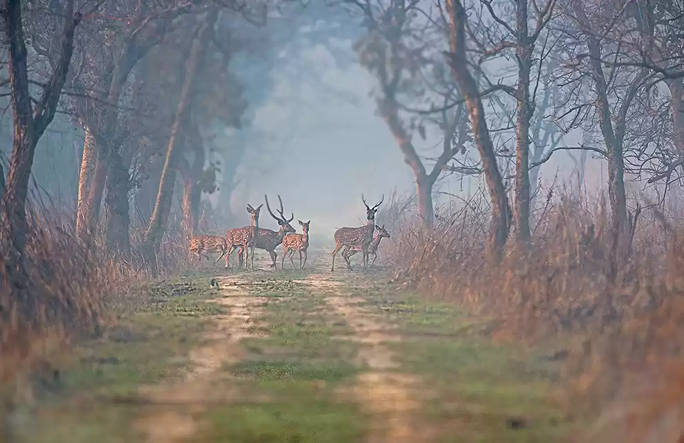
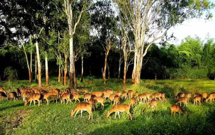
Nepal is a land of extreme contrasts in climate and geography, It has a unique topography ranging from lowlands with sub-tropical jungles to arctic conditions in the Himalayan highlands. Within a mere 150 kilometers the land rises from near sea level in the south to over 8000 meters in the North. This, together with the monsoon rainfall along the south facing slopes, has resulted in compacting virtually all climate zones found on planet Earth. As a result, Nepal has been endowed with a great diversity of life-zones providing a home for a large variety of plants, birds and animals. The Chitwan National Park (CNP) is a world heritage property, and it also contains a Ramsar Site – Beeshazari Tal in its buffer zone. The CNP has a history of over 3 decades in park management and a rich experience in resolving conflicts between the park and the people.It is a rich natural area in the Terai, the subtropical southern part of Nepal. A total of 68 species of mammals, 544 species of birds, 56 species of herpetofauna and 126 species of fish have been recorded in the park. The park is especially renowned for its protection of One Horned Rhinoceros, Royal Bengal Tiger and Gharial Crocodile.

Masada is not only important because it is a UNESCO World Heritage Site or an ancient fortress occupying a breathtaking strategic location high on a flat plateau above the Dead Sea, but because of its symbolic importance as a symbol of determination and heroism which continues to this day with many Israeli soldiers sworn in here. Masada is one of the greatest archaeological sites in Israel and, perha The fortress of Masada was built in the year 30 BCE by King Herod, whose architectural feats have left their mark throughout the country. Massada is situated on the top of a mountain with steep sides and a flat top like a parapet overlooking the desert panorama to the west and the Dead Sea to the east. The thrilling story of the site reveals the courage of the defenders of Massada and their battle against the conquering Romans. The story, related against the background of the ancient panorama, is as thrilling as a Hollywood movie, and is filled with tension, struggle, and love.The fortress of Massada was built in the year 30 BCE by King Herod, whose architectural feats have left their mark throughout the country. At the beginning of the great revolt against Rome in the year 68 BCE, the site was conquered by a group of Jewish zealots, and Massada became their last stronghold. In the year 72 the Romans besieged Massada and succeeded in reaching the steep fortress after constructing a huge earthen ramp on its western side. In the year 73, the 960 Jewish zealots living at the top of Massada chose to commit suicide rather than to fall into the hands of the Romans alive. Their deeds left behind a saga of courage, heroism, and martyrdom. Thailand: khao yai national park.

Ranthambore National Park is one of the biggest and most renowned national park in Northern India. The park is located in the Sawai Madhopur district of southeastern Rajasthan, which is about 130 km from Jaipur. Being considered as one of the famous and former hunting grounds of the Maharajas of Jaipur, today the Ranthambore National Park terrain is major wildlife tourist attraction spot that has pulled the attention of many wildlife photographers and lovers in this destination.Spread across an area of 392 sq kms, Ranthambore National Park is situated in the Sawai Madhopur district of Rajasthan. It is one of the largest and famous National Parks in India. Once known as the hunting base for Maharajas of Jaipur, Ranthambore National Park today is a major tourist destination. Ranthambore National Park is very famous for its tiger population. Tigers are often seen during the day, going about their regular chores. This national park is flanked by two sanctuaries namely Kaila Devi Sanctuary and the Mansingh Sanctuary. The park is also considered as a heritage site and has been home to many species of plants, reptiles and birds. It is also a place where some of the largest banyan trees in India are found. This national park has several lakes within its premises. The park draws lot of wildlife enthusiasts and photographers from all over the world.

Established by the French as a hill station in 1925, Bokor has since been abandoned twice, during World War II and the Khmer Rouge period. The area including Bokor ‘mountain’ was established as a national park in 1993 with its 1,500 square kilometres spanning four Cambodian provinces. Despite substantial illegal logging, it’s still home to gibbons, hornbills, civets and sunbears. Recent development of a new casino, hotel and hangar-like convention centre may have affected the ghostly ambiance of the hill station, but included building a wonderful curving road to the top of the hill, making Bokor much easier to access.The most beautiful and most mystical natural park of Southeast Asia, it is, of cource, Phnom Bokor. 140 thousand hectare of untouched mountain jungle, the biggest herd of wild elephants in Southeast Asia. Park Phnom Bokor is located in Elephant mountains being continuation Cardamon mountains (Kravan). Most park Phnom Bokor point – mountain Kamtjaj is high (Bokor, Phnom on khmer dictionary means – the mountain) has height of 1077 metres above sea level and is the point second for height point in Cambodia. At once at entrance to park virgin forests begin.

One of the national parks of Mongolia. It is about 80km north-east of Ulaanbaatar, is a deservedly popular destination. At 1600m, the area is cool and the alpine scenery is magnificent, and there are great opportunities for hiking, rock climbing, swimming (in icy water), rafting, horse riding and, for hard-core extreme sports fanatics, skiing in the depths of winter. The park has many rock formations for rock climbers, and includes two famous formations named for things they resemble: Turtle Rock (Mongolian: Melkhii Khad) and the Old Man Reading a Book (Praying Lama Rock). Terelj was first developed for tourism in 1964 and 30 years later it became part of the Gorkhi-Terelj National Park. To the north-east, the park joins into the Khan Khentii Strictly Protected Area, comprising over 1.2 million hectares of the Tov, Selenge and Khentii aimags. The Khan Khentii park is almost completely uninhabited by humans, but it is home to endangered species of moose, brown bear and weasel, to name but a few, and to over 250 species of birds.

With an area of 4,349 sq. km, the Jigme Dorji National Park is the largest protected area in Bhutan. It is one of the most biologically rich areas in the Eastern Himalayan region, and stretches from warm broad-leaved forests to permanent ice fields and glaciers on Bhutan’s north-western border.The monsoon rains and a varied topographical gradient, from just over 1,000 meters to more than 7,000 meters above sea level, account for this rich plant and animal diversity. Jigme Dorji National Park (JDNP) is the second largest national park in Bhutan with an area of 4316 sq. km. Located in the north western park of the country, the park also shares international border with the Tibetan Autonomous Region of China. The habitats ranging from subtropical (1,400 m; 4,600 ft.) to Alpine (7,000 m; 22,970 ft.). is rich in biodiversity with a present record of 36 mammals, 328 birds, 5 reptiles, 300 medicinal plants, and 39 butterflies. It was in JDNP where tigers were first sighted above 4000 meters sharing habitat with snow leopards. Besides the rich floral and faunal diversity, the sources of four major rivers, Pachhu, Wangchhu, Phochhu and Mochhu lie in the park as well.The park spans across 5 districts, namely Paro, Thimphu, Punakha, Wangduephodrang and Gasa. Park headquarters based in Damji, Gasa and its 4 range offices addresses common challenges faced by protected areas elsewhere, like human-wildlife conflicts, unsustainable collection/or use of forest resources, and illegal wildlife trade Satyr Tragopan (Tragopan satyra) and other high-altitude species are characteristic of this park, along with other rare birds associated with rivers in warm broadleaved forests, such as the White-bellied Heron, Palllas’s Fish Eagle, and Tawny Fish Owl (Bubo flavipes).

Jim Corbett National Park, which is a part of the larger Corbett Tiger Reserve, a Project Tiger Reserve lies in the Nainital district of Uttarakhand. The magical landscape of Corbett is well known and fabled for its tiger richness. Established in the year 1936 as Hailey National Park, Corbett has the glory of being India’s oldest and most prestigious National Park. It is also being honored as the place where Project Tiger was first launched in 1973. This unique tiger territory is best known as the father who gave birth of the Project Tiger in India to protect the most endangered species and the Royal of India called Tigers. Spans over an extent of 520 square kilometers, its whole area comprises of hills, marshy depressions, riverine belts, grasslands and large lake. It is among the few tiger reserves in India that allows overnight stays in the lap of the National Park. Nature watch and wildlife viewing in the park is done in an open four wheeler Jeep and on elephant back. Sheltering a healthy population of tigers and rare species like Otters and the endemic fish eating crocodile, the national park is one of the most sought after destinations for the wildlife buffs. Dhikala, situated at the border of the extensive Patil Dun valley, is the most popular destination in Corbett because of its superb location and sheer abundance of wildlife present.

Kaziranga National Park lies partly in Golaghat District and partly in Nagaon District of Assam. It is the oldest park in assam covers an area of 430 Sq kms along the river Brahmaputra on the North and the Karbi Anglong hills on the South. The National Highway 37 passes through the park area and tea estates, hemmed by table-top tea bushes. One can even see the rhinos and wild elephants straying near the highway.KAZIRANGA NATIONAL PARK, a name known worldwide for its success in the conservation history of one horned Indian Rhinoceros, provides habitat for a number of threatened species and migratory birds. A symbol of dedication for the conservation of animals and their habitat, Kaziranga, with a National Park status represents single large established protected area within the Burma Monsoon Forest Biogeographically Province to provide long term viable conservation. Spread over civil jurisdictions of Nagaon and Golaghat districts in Assam with mighty Brahmaputra river on the north and verdant Karbi Anglong hills on the south between Longitude 92° 50′ E & 93° 41′ E and Latitude 26° 30′ N and 26° 50′ N, Kaziranga National Park is an out standing example representing significant on going ecological and biological processes in the evolution and development of wet land ecosystem and communities of plants and animals. Kaziranga contains the most important and significant natural habitat for in-situ conservation of biological diversity, including those containing threatened species of outstanding universal value from the point of view of science or conservation. The above mentioned values and criteria made Kaziranga National Park to get inscribed on the world heritage list of “Convention concerning the protection of the world cultural and natural heritage” in the year 1985.

The Gir National Park and wildlife sanctuary is located about 65 km south east in the Junagadh district of Gujarat. Gir National Park is one of the India’s finest wildlife sanctuaries located in Gujarat. This national park is set up in an area of 1412 square km. of lush deciduous forests. This national park was established on 18th September 1965 as a Forest Reserve to conserve the Asiatic lion. This sanctuary is the final refuge of the rare Asian lions which roamed freely two centuries ago throughout Middle East and some parts of India. Sasan, with a forest rest house, is the headquarters of the sanctuary. Since 1884, Gir National Park has been the only habitat of the Asiatic lion. During the British Raj, lions were hunted mercilessly by the British officers assisted by the obliging Maharajas and Nawabs. Every Maharaja was proud of the number of lions or tigers he killed during his lifetime. In the year 1899 the famine decreased the lion population so badly that Lord Curzon cancelled his shoot in Gir where he had been invited by the Nawab for a ‘Shikaar’. The Lord Curzon also advised the ruler to protect the remaining lions. By the time India achieved independence, the number of lions get increased, but they were once again hunted by the Maharajas. The Government of India banned the hunting of lion in the mid 1960 and now this park is open only for the photo safaris. The Gir National Park later became a major tourist attraction in India. About 300 lions are found in this park.

Kanha Tiger Reserve is spread over an area of 1,949 sq km (940 sq km of core area and 1,009 sq km of buffer zone), making it one of the best habitats for tigers in India (the current dominant male, Munna, is easily recognized by a symbol on his forehead that reads – “CAT”). The park is situated in the Central Indian Highlands, which are part of the extensive tableland that forms India’s main peninsula. The highlands once were continuous forests and accounted for a significant part of the country’s wilderness areas and wildlife habitats. Today, these forests have become fragmented and survive in parks such as Panna, Bandhavgarh, Kanha, Pench and Sanjay.The sal forests and vast meadows contain tigers (89 at last count) and leopards and support huge populations of deer and antelope, including the rare barasingha (deer). You’ll see plenty of langur monkeys, the odd gaur (Indian bison), maybe even a family or two of wild boar and the odd lonesome jackal or two. The park is also home to more than 300 bird species.Khatiya Gate in Khatiya village is easily the most popular; other gates into the park include Mukki, 45km southeast of Khatiya, and Sarahi, 60km northeast.

Valley of Flowers National Park is an Indian national park, located at a height in West Himalaya. It is renowned for its meadows of endemic alpine flowers and the variety of flora found there. It is located in Uttarakhand state. This richly diverse area is also home to rare and endangered animals, including the Asiatic black bear, snow leopard, brown bear and blue sheep. The gentle landscape of the Valley of Flowers National Park complements the rugged mountain wilderness of Nanda Devi National Park to the east. Together they encompass a unique transition zone between the mountain ranges of the Zanskar and Great Himalaya. The park stretches over an expanse of 87.50 km². Both parks are encompassed in the Nanda Devi Biosphere Reserve (223,674 ha) which is further surrounded by a buffer zone (5,148.57 km²). The valley had always been known to the local people who avoided getting to this area for fear of fairies, who they believed, would take them away. It was in 1931 that Frank Smythe and Holdsworth stumbled into the valley while returning from their successful Kamet expedition and were “at once transported from a region of solemn austerity to a fairy land of dainty flowers, most of them dwarf but brilliant in colour”. Smythe wrote about the valley and its flowers – “their carpet is a celestial one, breathing innocence and joy to the world overburdened with sophistication and sorrow”. His writing invoked a great interest of the people in this valley, both at home and abroad. Legends associate this valley area with “Gandhamadan” from where Hanuman of Ramayana collected “Sanjeevani” herb to revive Laksmana. Hanuman had to visit far-flung areas in his search for the life-saving herb, some named after him. He visited Hanuman Chatti near Yamunotri, Hanuman Tibba near Gangotri, Hanuman peak near Nandadevi, Hanuman Chatti near Badrinath and ultimately the valley of flowers or Nanankanan as it is also known as.

Sunderbans National Park, the land where entire wildlife embroidered to the perfection, is situated in South 24 Parganas at the most charismatic location of Sundarban delta which is largest delta of the world. In 1973 entire land of sundarbans national park was declared tiger reserve, in 1977 wildlife sanctuary and on fourth day of May 1984 as a national park and in 1987 a new lesson was added by UNESCO when they titled it as world heritage site. The national park is a mazy network of tiny islands, mudflats and tidal waterways which present a very good example of a natural awe-inspiring scenery. Sunderban consists an area of about 4100 sq kilometers out of which around 1700 sq kilometers are river, canals or creeks. The area is not only known for natural scenery and tiger it’s also abode of wide range of fauna and flora including 58 species of mammals, 55 species of reptiles and around 250 species of birds.

Frequent Searches Leading To This Page:-
bokor national park cambodia, phnom bokor national park cambodia, bokor hill national park cambodia, preah monivong bokor national park cambodia, list of best national parks in the world


' fill='%23359391'%3e %3cpath d='M46.1538462%2c43.5714286 L41.5%2c50 L36.8461538%2c43.5714286 L36.8670256%2c43.5714286 C36.3173077%2c42.7142857 36%2c41.6851429 36%2c40.5714286 C36%2c37.4854286 38.4535641%2c35 41.5%2c35 C44.5464359%2c35 47%2c37.4854286 47%2c40.5714286 C47%2c41.6851429 46.6826923%2c42.7142857 46.1329744%2c43.5714286 L46.1538462%2c43.5714286 Z M41.4294872%2c39 C40.6150641%2c39 39.9487179%2c39.675 39.9487179%2c40.5 C39.9487179%2c41.325 40.6150641%2c42 41.4294872%2c42 C42.2439103%2c42 42.9102564%2c41.325 42.9102564%2c40.5 C42.9102564%2c39.675 42.2439103%2c39 41.4294872%2c39 L41.4294872%2c39 Z' id='Location-white'%3e%3c/path%3e %3c/g%3e %3c/svg%3e)